more stats
1,916 ft
Distance
-300 ft
Descent
00:03:24
Avg time
-300 ft
Altitude change
2,216 ft
Altitude min
2,516 ft
Altitude max
2,516 ft
Altitude start
2,218 ft
Altitude end
-15.7%
Grade
-43.1%
Grade max
-0.6%
Grade min
1,837 ft
Distance down
79 ft
Distance flat
00:03:24
Avg time

Short & Sharp Details

  • Activities
    • Mountain Bike
  • Riding Area
  • Difficulty Rating
  • Voted Difficulty
    Black Diamond (2 votes)
  • Local Popularity
    30 in Mountain Biking
  • Global Ranking
    #105512 in Mountain Biking
  • Trail Type
    Singletrack
  • Bike Type
    AM, XC
  • Direction
    Downhill Only
    Popular Direction Shown
  • Physical Rating
    Extreme
  • eBike Allowed
    Yes up to Class 1
  • TTFs on Trail
    Berm, Drop, Rock Face, Rock Garden
  • Land Owner
    CMTEDD - National Arboretum Canberra/Stromlo Forest Park

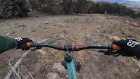
Short & Sharp starts directly from [L=https://www.trailforks.com/trails/western-wedgetail/]Western Wedgetail[/L] taking you down some of the most technical trail Stromlo has to offer. Including technical rock gardens, drops & a steep rock roll there's plenty to keep you on your toes.

Trail Supporters

Bike Park

Local Trail Association
Traditionally Indigenous Territory

Recent Activity on Trail

Past Week
  • 0 rides
  •  
6 Months
  • 15 rides
  • 11 miles avg distance
All
  • 98 rides
  • Last: Jun 1, 2026
c1c2c3c4
January
February
March
April
May
June
July
August
September
October
November
December
Status:
on Aug 12, 2023
Dry
Avg: 3.76 (5 votes)
Your vote: 0

view (1,565)
close
3D
Trail Conditions
  • Unknown
  • Snow Groomed
  • Snow Packed
  • Snow Covered
  • Snow Cover Partial
  • Freeze/thaw Cycle
  • Icy
  • Prevalent Mud
  • Wet
  • Variable
  • Ideal
  • Dry
  • Very Dry
Trail Flow (Ridden Direction)
Trailforks scans users ridelogs to determine the most popular direction each trail is ridden. A good flowing trail network will have most trails flowing in a single direction according to their intension.
The colour categories are based on what percentage of riders are riding a trail in its intended direction.
  • > 96%
  • > 90%
  • > 80%
  • > 70%
  • > 50%
  • < 50%
  • bi-directional trail
  • no data
Trail Last Ridden
Trailforks scans ridelogs to determine the last time a trail was ridden.
  • < 2 days
  • < 1 week
  • < 2 weeks
  • < 1 month
  • < 6 months
  • > 6 months
Trail Ridden Direction
The intended direction a trail should be ridden.
  • Downhill Only
  • Downhill Primary
  • Both Directions
  • Uphill Primary
  • Uphill Only
  • One Direction
Contribute Details
Colors indicate trail is missing specified detail.
  • Description
  • Photos
  • Description & Photos
  • Videos
Trail Popularity ?
Trailforks scans ridelogs to determine which trails are ridden the most in the last 9 months. Trails are compared with nearby trails in the same city region with a possible 25 colour shades. Think of this as a heatmap, more rides = more kinetic energy = warmer colors.
  • most popular
  • popular
  • less popular
  • not popular
ATV/ORV/OHV Filter
Max Vehicle Width
inches
US Cell Coverage
Legend
cell carrier legend

Radar Time
Activity Recordings
Trailforks uses anonymized public activity data. ?
Activity Recordings
Trailforks uses anonymized public activity data. ?
Personal Heatmap
Activity Types
all / none
Options
2
Date range month
Winter Trails
Warning A routing network for winter maps does not exist. Selecting trails using the winter trails layer has been disabled.
Missing Trails
Most Popular
Least Popular
Trails are colored based on popularity. The more popular a trail is, the more red. Less popular trails trend towards green.
Jump Magnitude Heatmap
Heatmap of where riders jump on trails. Zoom in to see individual jumps, click circles to view jump details.
BC Backroad Status

Service Road Atlas is a free to use, community-driven service for viewing and creating reports on the numerous back-country service roads around B.C. and Alberta.

map legend
Slope Aspect
Direction the slope faces
Flat N NE E SE S SW W NW
Trails Deemphasized
Trails are shown in grey.
disable
Only show trails with no bike usage.
Enable
Suggested Layers
Based on selected activity type

    Save the current map location and zoom level as your default home location whenever this page is loaded.

    Save
        Directions to short--sharp trailhead (-35.313240, 149.008480)

        Photos

        3 more »
        56 |
        Aug 2, 2025 @ 1:35am
        Aug 2, 2025
        69 |
        Aug 2, 2025 @ 1:01am
        Aug 2, 2025
        52 |
        Nov 29, 2024 @ 1:20pm
        Nov 29, 2024

        Videos

        2 more »
        Stromlo Bike Park Short N Sharp
        3:49 | 1291 | May 5, 2021 , Canberra
        Stromlo’s hidden gems| Short and Sharp
        2:34 | 123 | Aug 2, 2025 , Canberra

        Routes with this trail

        41 miles 7,928 ft 115 Loop
        Planning for a Stromlo big loop
        40 miles 6,253 ft 118
        Full set of Stromlo trails, missing only a B line and short links.
        3.5 9 miles 1,831 ft 54
        Round 2 of the CORC Gravity Enduro Series held a Stromlo - 23 June 2019 A four stage race on some of...

        5 Reviews & Comments


        We hope you've been enjoying Trailforks!

        Create a FREE account to view trail comments and much more.

        • By ZippyBlingTF Pro & contributors
        • #70015 - 3,215 views

        Frequently Asked Questions About Short & Sharp

        Where is Short & Sharp located?
        Short & Sharp is located in UC Stromlo Forest Park, Canberra, Australia. It is part of the UC Stromlo Forest Park trail network. The trailhead is located at coordinates -35.31324, 149.00848.
        How hard is Short & Sharp?
        Short & Sharp is rated as Double Black Diamond difficulty. The physical rating is Extreme. The average grade is 15.7%.
        What is the elevation gain for Short & Sharp?
        The trail has 300 ft of elevation descent. The elevation ranges from 2,216 ft to 2,516 ft.
        Is Short & Sharp a point to point trail?
        Yes, Short & Sharp is a point to point trail. The direction is Downhill Only. The trail type is singletrack.

        Hit the Trail

        Open in App

        Get this trail on your phone instantly.
        open trail in app

        Download Trail

        Save to wishlist, Garmin & download.
        save the trail

        Find Related Routes

        Find routes and users activities that include this trail.
        find routes for this trail

        You must enter a description before submitting.