4,347 ft
Distance
71 ft
Climb
-139 ft
Descent
00:07:28
Avg time

Sideshow Bob Details

  • Activities
    • Mountain Bike
    • E-Bike
    • Hike
    • Trail Running
  • Riding Area
    Bowmont Park
    Calgary, Alberta
  • Difficulty Rating
  • Voted Difficulty
    Blue (1 vote)
  • Hiking SAC Scale
    T1 Hiking
  • Trail Type
    Singletrack
  • Bike Type
    AM, XC, Fat, CX
  • Direction
    Downhill Only
    Popular direction shown
  • Climb Difficulty
    Blue
  • Physical Rating
    Moderate
  • Trail Visibility
    Always easy to follow
  • Dogs Allowed
    Yes
  • eBike Allowed
    Yes up to Class 1
  • Global Ranking
    #5256 in Mountain Biking [+]
    • #21447 in E-Biking
    • #5998 in Trail Running
    • #52744 in Hiking
  • Local Popularity
    95 in Mountain Biking [+]
    • 95 in E-Biking
    • 75 in Trail Running
    • 75 in Hiking
  • Land Owner
    City of Calgary

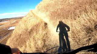
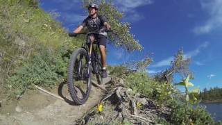
Begins with a trail alongside the cliff-face of Bowmont park, then into a short tree section, onto the cliffs again, and finishes through trees to a pathway in the middle of Bowmont park. If you don't like exposure, this is not the trail for you.

To avoid collisions at the blind spots, let's ride this in the downhill direction, from east to west.

Local Trail Association
More Stats for Sideshow Bob mountain bike trail trail
  • Altitude change
    -68 ft
  • Altitude min
    3,528 ft
  • Altitude max
    3,617 ft
  • Altitude start
    3,615 ft
  • Altitude end
    3,547 ft
  • Grade
    -1.6%
  • Grade max
    -23%
  • Grade min
    16.2%
  • Distance climb
    1,795 ft
  • Distance down
    2,014 ft
  • Distance flat
    541 ft
  • Avg time
    00:07:28
  • Avg reverse time
    00:11:20
  • view trail stats
Status:
on May 20, 2025
Ideal
Avg: 4.07 (23 votes)
Your vote: 0

view (5,077)
close
3D
Trail Conditions
  • Unknown
  • Snow Groomed
  • Snow Packed
  • Snow Covered
  • Snow Cover Partial
  • Freeze/thaw Cycle
  • Icy
  • Prevalent Mud
  • Wet
  • Variable
  • Ideal
  • Dry
  • Very Dry
Trail Flow (Ridden Direction)
Trailforks scans users ridelogs to determine the most popular direction each trail is ridden. A good flowing trail network will have most trails flowing in a single direction according to their intension.
The colour categories are based on what percentage of riders are riding a trail in its intended direction.
  • > 96%
  • > 90%
  • > 80%
  • > 70%
  • > 50%
  • < 50%
  • bi-directional trail
  • no data
Trail Last Ridden
Trailforks scans ridelogs to determine the last time a trail was ridden.
  • < 2 days
  • < 1 week
  • < 2 weeks
  • < 1 month
  • < 6 months
  • > 6 months
Trail Ridden Direction
The intended direction a trail should be ridden.
  • Downhill Only
  • Downhill Primary
  • Both Directions
  • Uphill Primary
  • Uphill Only
  • One Direction
Contribute Details
Colors indicate trail is missing specified detail.
  • Description
  • Photos
  • Description & Photos
  • Videos
Trail Popularity ?
Trailforks scans ridelogs to determine which trails are ridden the most in the last 9 months. Trails are compared with nearby trails in the same city region with a possible 25 colour shades. Think of this as a heatmap, more rides = more kinetic energy = warmer colors.
  • most popular
  • popular
  • less popular
  • not popular
ATV/ORV/OHV Filter
Max Vehicle Width
inches
US Cell Coverage
Legend
cell carrier legend

Radar Time
x Activity Recordings
Trailforks users anonymized public ridelogs from the past 6 months.
  • mountain biking recent
  • mountain biking (>6 month)
  • hiking (1 year)
  • moto (1 year)
Activity Recordings
Trailforks users anonymized public skilogs from the past 12 months.
  • Downhill Ski
  • Backcountry Ski
  • Nordic Ski
  • Snowmobile
Winter Trails
Warning A routing network for winter maps does not exist. Selecting trails using the winter trails layer has been disabled.
x Missing Trails
Most Popular
Least Popular
Trails are colored based on popularity. The more popular a trail is, the more red. Less popular trails trend towards green.
Jump Magnitude Heatmap
Heatmap of where riders jump on trails. Zoom in to see individual jumps, click circles to view jump details.
Trails Deemphasized
Trails are shown in grey.
disable
Only show trails with NO bikes.
enable

Save the current map location and zoom level as your default home location whenever this page is loaded.

Save
      Directions to sideshow-bob trailhead (51.085710, -114.164330)
      update trails status or condition

      Sideshow Bob Trail Reports

      statusdatedescription
      May 20, 2025 @ 10:43am
      May 20, 2025
      dried out good to ride
      May 17, 2025 @ 4:10pm
      May 17, 2025
      There’s been enough rain that it’s now in perfect condition. No dust and no mud!
      May 4, 2025 @ 1:21pm
      May 4, 2025
      Apr 19, 2025 @ 11:18am
      Apr 19, 2025
      Mar 5, 2025 @ 7:26pm
      Mar 5, 2025
      Sun-exposed areas (east end) are dry, except for the entry off the road. Still very wet in the trees.
      view all reports »

      Recent Ridelog Activity on Trail

      Past Week
      • 2 rides
      • 7 miles avg distance
      6 Months
      • 92 rides
      • 9 miles avg distance
      All
      • 582 rides
      • Last: Jul 18, 2025

      Photos

      more »
      576 |
      Jul 22, 2018 @ 5:50am
      Jul 22, 2018
      72 |
      Nov 11, 2023 @ 5:52pm
      Nov 11, 2023
      89 |
      Sep 29, 2022 @ 8:11pm
      Sep 29, 2022
      115 |
      Jun 12, 2022 @ 9:27am
      Jun 12, 2022

      Trail Lists

      Routes with this trail

      titledistance
      Sideshow Bob to 12 Mile Coulee7 miles
      #RideCMBA Bowmont Short Loop7 miles
      Bowmont Short4 miles

      5 Reviews & Comments


      We hope you've been enjoying Trailforks!

      Create a FREE account to view trail comments and much more.

      Videos

      more »
      Bowmont Rip - Calgary, AB, Mountain Bike POV
      3:24 | 735 | Nov 7, 2021 , Calgary
      Early Spring Riding! Sideshow Bob | Calgary
      3:39 | 863 | Apr 1, 2021 , Calgary
      Sideshow Bob /Bowmout park
      3:03 | 962 | Jan 19, 2021 , Calgary
      Go it Alone - Mountain Bike Trails Calgary
      2253 | Sep 8, 2016 , Calgary
      • By thelug3r & contributors
      • #16973 - 25,699 views

      You must enter a description before submitting.