



more stats
4,849 ft
Distance
11 ft
Climb
-283 ft
Descent
00:08:35
Avg time
-271 ft
Altitude change
1,585 ft
Altitude min
1,856 ft
Altitude max
1,856 ft
Altitude start
1,585 ft
Altitude end
-5.6%
Grade
-33%
Grade max
8%
Grade min
866 ft
Distance climb
3,691 ft
Distance down
259 ft
Distance flat
00:08:35
Avg time

Sílex Details

  • Activities
    • Mountain Bike
    • E-Bike
    • Hike
    • Trail Running
  • Riding Area
  • Difficulty Rating
  • Local Popularity
    75 in Mountain Biking [+]
    • 85 in E-Biking
    • 75 in Trail Running
    • 100 in Hiking
  • Global Ranking
    #129419 in Mountain Biking [+]
    • #1934 in E-Biking
    • #129201 in Trail Running
    • #92544 in Hiking
  • National Ranking
    #11,145 in Mountain Biking · Spain [+]
    • #893 in E-Biking
    • #11,163 in Trail Running
    • #6,039 in Hiking
  • Trail Type
    Singletrack
  • Bike Type
    AM, XC
  • Direction
    Downhill Primary
    Popular Direction Shown
  • Climb Difficulty
    Blue
  • Physical Rating
    Moderate
  • Trail Visibility
    Always easy to follow
  • Dogs Allowed
    Yes
  • eBike Allowed
    Yes up to Class 1
  • Land Owner
    Associació Lo Podall

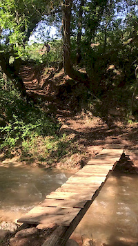
Trail que uneix el Camí de Sallent amb el final del ZZ. Es de terreny variat i divertit, En el primer terç te una pujada curta però dura per salvar una petita allau. Després un seguit de corves ràpides ens duran fins al creuament del sender que baixa de Sta. Engracia. Anirem baixant pel marge del barranc de Seròs fins creuar-lo per una palanca de fusta. Un cop a l'altre costat de barranc anirem seguint pel traçat d'un antic canal on hi haurà algun punt que haurem de baixar de la bici degut a la seva estretor. Ja estem a l'antiga cantera del Sílex que vorejarem fins donar el pont de pedra on arriba el ZZ 2.0.

Tags
Bridges

Local Trail Association

Recent Activity on Trail

Past Week
  • 0 rides
  •  
6 Months
  • 9 rides
  • 21 miles avg distance
All
  • 119 rides
  • Last: Oct 21, 2026
Status:
on Oct 17, 2026
Ideal
Avg: 4.31 (16 votes)
Your vote: 0

view (1,365)
close
      Directions to silex trailhead (42.192110, 0.895450)

      Photos

      9 more »
      mtb
      205 |
      Oct 10, 2021 @ 11:05pm
      Oct 10, 2021
      mtb
      75 |
      May 26, 2026 @ 3:50am
      May 26, 2026
      mtb
      98 |
      Feb 5, 2026 @ 4:47pm
      Feb 5, 2026
      mtb
      129 |
      Jun 3, 2023 @ 5:04am
      Jun 3, 2023

      Videos

      3 more »
      Salida Endurera a Tremp (Sin Noticias de Gurp).
      mtb
      33:21 | 89 | May 3, 2025 , Tremp
      mtb
      0:09 | 271 | May 19, 2020 , Tremp
      TC1 / TC3 Bucardo 2022 - Sílex - Entrenament...
      ebike
      4:59 | 291 | May 23, 2022 , Tremp

      Routes with this trail

      ★ 5.0 • 16 miles • 2,441 ft • 5 • Loop •
      Ruta cap a Roques Pelades passant per altres trails interessants. ESP: Ruta que va a Roques pelades y que...
      ★ 4.5 • 19 miles • 3,111 ft • 10 • Loop •
      Ruta que ens porta al carener de Roques Pelades on trencarem a esquerra per endinsar-nos al revirat sender...
      ★ 4.0 • 28 miles • 5,515 ft • 12 • Loop •
      Ruta que ens porta a un dels cims més emblemàtics del municipi de Tremp: Pui de Lleràs (1691m.) o Pleta...
      4.5 ★★★★★
      16 Ratings
      5 ★ 56%
      4 ★ 38%
      3 ★ 6%
      2 ★
      1 ★

      2 Reviews & Comments

      unioncyclistelumberjack unioncyclistelumberjack
      La millor manera i més pepinera per anar de Talarn en direcció a la pista de Santa Engràcia!

      We hope you've been enjoying Trailforks!

      Create a FREE account to view all trail reviews and much more.

      Frequently Asked Questions

      ▼ Where is Sílex located?
      Sílex is located in Territori Lo Podall Tremp, Tremp, Spain. It is part of the Territori Lo Podall Tremp trail network. The trailhead is located at coordinates 42.19211, 0.89545.
      ▼ How hard is Sílex?
      Sílex is rated as Blue difficulty. The physical rating is Moderate. The average grade is 5.6%. The climb difficulty is rated Blue.
      ▼ What is the elevation gain for Sílex?
      Sílex has 11 ft of elevation gain. The trail has 283 ft of elevation descent. The elevation ranges from 1,585 ft to 1,856 ft.
      ▼ Is Sílex a point to point trail?
      Sílex is not a point to point trail. The direction is Downhill Primary. The trail type is singletrack.
      ▼ How long is Sílex?
      Sílex is 4,849 ft long. The trail type is singletrack.
      ▼ Are dogs allowed on Sílex?
      Yes, dogs are allowed on Sílex. Please keep dogs on a leash where required and clean up after them.
      ▼ How do I access Sílex? Where is the closest parking trailhead?
      The closest parking and trailhead locations to Sílex are: View all parking locations in the area.
      ▼ How long does it take to ride Sílex?
      Based on recorded activities, it takes an average of 9 minutes to ride Sílex. The trail is 4,849 ft long. Actual times will vary based on fitness level, conditions, and pace. View recent activity logs for more details.
      ▼ How busy is Sílex?
      Sílex is a very popular trail. There have been 1,360 recorded activities on this trail. The trail has received 1,365 check-ins. View recent activity on this trail.

      Hit the Trail

      Open in App

      Get this trail on your phone instantly.

      open trail in app

      Download Trail

      Save to wishlist, Garmin & download.
      save the trail

      Find Related Routes

      Find routes and users activities that include this trail.
      find routes for this trail

      You must enter a description before submitting.

