2,428 ft
Distance
-275 ft
Descent
00:13:20
Avg time
Singletrack Mind Details
-
Activities
- Mountain Bike
- E-Bike
- Hike
- Trail Running
- Observed Trials
-
Riding AreaValleycliffe
Squamish, British Columbia -
Difficulty Rating
-
Trail TypeSingletrack
-
Bike TypeAM, XC
-
Trail UsageMulti-use
-
DirectionDownhill OnlyPopular direction shown
-
Climb DifficultyBlue
-
Physical RatingModerate
-
SeasonMarch - November
-
Dogs AllowedYes
-
eBike Allowed
-
TTFs on TrailRock Face
-
Global Ranking#20088 in Mountain Biking
-
Local Popularity85 in Mountain Biking [+]
- 95 in E-Biking
- 55 in Trail Running
- 45 in Hiking
- 40 in Observed Trials
-
Land ManagerDiamond Head Land Co
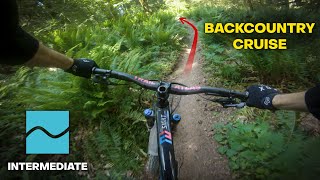
A flowy blue addition to the Valleycliffe network. Climbable single track up to a scenic rock slab look out point, and then the fun descent starts. Leads back towards to bottom of Farside Trail. One of the few flowy trails in Valleycliffe and one of the top blue trails in town.
Access Info
Climb Fartherside (from either end) until the junction with Singletrack Mind. The climb can be somewhat confusing, as there are numerous forks with various moto trials trails. When starting the climb take the initial left fork, and then for all additional forks take the most obvious/most traveled option.
Local Trail Association
-
Please consider joining or donating to the local trail association to supportdonate to earn trail karma!
trail development & maintenance.
More Stats for Singletrack Mind mountain bike trail trail
-
Altitude change-275 ft
-
Altitude min435 ft
-
Altitude max710 ft
-
Altitude start710 ft
-
Altitude end436 ft
-
Grade-11.3%
-
Grade max-28.6%
-
Grade min-2.6%
-
Distance down2,428 ft
-
Avg time00:13:20
-
Avg reverse time00:19:23
- view trail stats
close
Trail Conditions
- Unknown
- Snow Groomed
- Snow Packed
- Snow Covered
- Freeze/thaw Cycle
- Icy
- Prevalent Mud
- Wet
- Variable
- Ideal
- Dry
- Very Dry
Trail Ridden Direction
Trailforks scans users ridelogs to determine the most popular direction each trail is ridden. A good flowing trail network will have most trails flowing in a single direction according to their intension.
The colour categories are based on what percentage of riders are riding a trail in its intended direction.
- > 96%
- > 90%
- > 80%
- > 70%
- > 50%
- < 50%
Trail Last Ridden
Trailforks scans ridelogs to determine the last time a trail was ridden.
- < 2 days
- < 1 week
- < 2 weeks
- < 1 month
- < 6 months
- > 6 months
Trail Ridden Direction
The intended direction a trail should be ridden.
- Downhill Only
- Downhill Primary
- Both Directions
- Uphill Primary
- Uphill Only
- One Direction
ContributeDetails
Colors indicate trail is missing specified detail.
- Description
- Photos
- Description & Photos
- Videos
Trail Popularity ?
Trailforks scans ridelogs to determine which trails are ridden the most in the last 9 months.
Trails are compared with nearby trails in the same city region with a possible 25 colour shades.
Think of this as a heatmap, more rides = more kinetic energy = warmer colors.
- most popular
- popular
- less popular
- not popular
ATV/ORV/OHV Filter
Max Vehicle Width
inches
Radar Time
LEGEND
Trail Difficulties
Trail Report Status
- Access Road/Trail
- White
- Green
- Blue
- Black
- Double Black Diamond
Trail Report Status
- Clear / Green
- Minor Issue / Yellow
- Significant Issue / Amber
- Closed
- Land Owner Overlay
- Wilderness (typically no bikes in USA)
- BLM (public)
- USFS (Wildlife sanctuaries darker than usfs)
- State land
- Indigenous
- Military
Trail Conditions
- Unknown
- Snow Groomed
- Snow Packed
- Snow Covered
- Freeze/thaw Cycle
- Icy
- Prevalent Mud
- Wet
- Variable
- Ideal
- Dry
- Very Dry
- Map Markers
Trail Head
Photo
Directory Listing
Riding Area
TTF
Parking
Viewpoint
Information
Warning
Directions
Sight
Restrooms
eBike Charging Point
Water Fountain/Source
Gate
Trail Sign
Table or Bench
Ladder
Stairs
Bridge
Boardwalk
Camping
Cabin
Lodge
Bear Cache
Dock
Ranger Station
Summit
Other
Directions to singletrack-mind trailhead
(49.716650, -123.100360)
update trails status or condition
Singletrack Mind Trail Reports
view all reports »
Recent Ridelog Activity on Trail
Past Week
- 10 rides
- 10 miles avg distance
6 Months
- 226 rides
- 10 miles avg distance
All
- 1,325 rides
Photos
more »
Routes with this trail
Trail Products
-
SORCA Trail SupporterTrail Pass
-
+ 0
Rmeritz
(Jul 26, 2018 at 20:12)

Pretty consistently challenging for a blue trail.
[Reply]


Great trail. Fast, loamy and natural. However I would say that it is more of a black trail.
[Reply]

Agreed with the above comments. It's a challenging blue for the most part but the rock slab and drop adds some gnar. Sick trail!
[Reply]
bl858
(Jul 11, 2019 at 17:47)

Signs for "bone saw" and another I can't remember had me thinking I was lost, but TF seemed to think I was on route.
[Reply]
HulaOtter
(Nov 8, 2019 at 16:53)
Fun trail and useful access to "Tomorrow" but signage is a little confusing. Best just to follow Trailforks app and don't be misled by grey metal signs on the route that read: "Glosettes"; "Boney View"; "Barber Chair".
[Reply]
Videos
more »
youtuber

5:55 |
992 |
Aug 1, 2018 , Squamish
Nearby Trails
- Glosettes 2 951 ft
- Bone View 2.0 1,093 ft
- Tomorrow 1,214 ft
- Omt 1,214 ft
- Glosettes 3 1,283 ft
- embed Singletrack Mind trail on your website
- By brenthillier
NSMBA TRAILFORKS Plus & contributors
- #126074 - 4,374 views
- subscribe
- login to download gpx or kml files.
Open trail in mobile app