more stats
5,157 ft
Distance
96 ft
Climb
-162 ft
Descent
00:09:26
Avg time
-68 ft
Altitude change
1,209 ft
Altitude min
1,336 ft
Altitude max
1,277 ft
Altitude start
1,207 ft
Altitude end
-1.3%
Grade
-16.3%
Grade max
21.9%
Grade min
1,230 ft
Distance climb
2,215 ft
Distance down
1,713 ft
Distance flat
00:09:26
Avg time

Sinter Details

  • Activities
    • Mountain Bike
    • Winter Fat Bike
  • Riding Area
    Cuyuna Lakes - Mahnomen Unit (North)
    Crosby-Ironton, Minnesota
  • Difficulty Rating
  • Voted Difficulty
    Black Diamond (1 vote)
  • Local Popularity
    50 in Mountain Biking
  • Global Ranking
    #31458 in Mountain Biking
  • Trail Type
    Singletrack
  • Bike Type
    AM, XC, Fat
  • Climb Difficulty
    Green
  • Physical Rating
    Hard
  • Trail Visibility
    Always easy to follow
  • Season
    Spring to Fall
  • Dogs Allowed
    Yes
  • eBike Allowed
    Yes up to Class 1
  • TTFs on Trail
    Berm, Drop, Jump, Rock Garden
  • Year Opened
    2021
  • Land Owner
    Minnesota Department of Natural Resources (MNDNR)

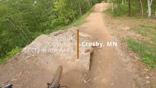
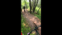
Trail Type: Singletrack – Flow/Jump trail (AM)

Trail Experience: A fast, flowy trail with plenty of rock gardens, tombstone jumps, drops, tabletops and step-ups. Starts with a gentle climbing and traverse section that has a wonderful overlook before heading down into the party zone. Most jumps or features have 2 options - roll it or huck it.

Strava Segments: TBD

Access Info

From Backcountry

Trail Supporters
Local Trail Association

Recent Activity on Trail

Past Week
  • 0 rides
  •  
6 Months
  • 12 rides
  • 20 miles avg distance
All
  • 369 rides
  • Last: Jun 6, 2026
c1c2c3c4
January
February
March
April
May
June
July
August
September
October
November
December
update trails status or condition

Sinter Trail Reports

statusdatedescription
Apr 22, 2026 @ 9:14am (America/Chicago)
Apr 22, 2026
reporter Open for summer! there may be debris that needs to be cleaned off the trails
Apr 14, 2026 @ 4:42pm (America/Chicago)
Apr 14, 2026
reporter
Jun 14, 2025 @ 10:46am
Jun 14, 2025
Apr 30, 2025 @ 6:24am
Apr 30, 2025
Open
Apr 18, 2025 @ 9:17pm
Apr 18, 2025
reporter Welcome to Trail Opening Weekend
more »
Status:
on Apr 22, 2026
Variable
Avg: 3.99 (9 votes)
Your vote: 0

view (2,229)
close
3D
Trail Conditions
  • Unknown
  • Snow Groomed
  • Snow Packed
  • Snow Covered
  • Snow Cover Partial
  • Freeze/thaw Cycle
  • Icy
  • Prevalent Mud
  • Wet
  • Variable
  • Ideal
  • Dry
  • Very Dry
Trail Flow (Ridden Direction)
Trailforks scans users ridelogs to determine the most popular direction each trail is ridden. A good flowing trail network will have most trails flowing in a single direction according to their intension.
The colour categories are based on what percentage of riders are riding a trail in its intended direction.
  • > 96%
  • > 90%
  • > 80%
  • > 70%
  • > 50%
  • < 50%
  • bi-directional trail
  • no data
Trail Last Ridden
Trailforks scans ridelogs to determine the last time a trail was ridden.
  • < 2 days
  • < 1 week
  • < 2 weeks
  • < 1 month
  • < 6 months
  • > 6 months
Trail Ridden Direction
The intended direction a trail should be ridden.
  • Downhill Only
  • Downhill Primary
  • Both Directions
  • Uphill Primary
  • Uphill Only
  • One Direction
Contribute Details
Colors indicate trail is missing specified detail.
  • Description
  • Photos
  • Description & Photos
  • Videos
Trail Popularity ?
Trailforks scans ridelogs to determine which trails are ridden the most in the last 9 months. Trails are compared with nearby trails in the same city region with a possible 25 colour shades. Think of this as a heatmap, more rides = more kinetic energy = warmer colors.
  • most popular
  • popular
  • less popular
  • not popular
ATV/ORV/OHV Filter
Max Vehicle Width
inches
US Cell Coverage
Legend
cell carrier legend

Radar Time
Activity Recordings
Trailforks uses anonymized public activity data. ?
Activity Recordings
Trailforks uses anonymized public activity data. ?
Personal Heatmap
Activity Types
all / none
Options
2
Date range month
Winter Trails
Warning A routing network for winter maps does not exist. Selecting trails using the winter trails layer has been disabled.
Missing Trails
Most Popular
Least Popular
Trails are colored based on popularity. The more popular a trail is, the more red. Less popular trails trend towards green.
Jump Magnitude Heatmap
Heatmap of where riders jump on trails. Zoom in to see individual jumps, click circles to view jump details.
BC Backroad Status

Service Road Atlas is a free to use, community-driven service for viewing and creating reports on the numerous back-country service roads around B.C. and Alberta.

map legend
Slope Aspect
Direction the slope faces
Flat N NE E SE S SW W NW
Trails Deemphasized
Trails are shown in grey.
disable
Only show trails with no bike usage.
Enable
Suggested Layers
Based on selected activity type

    Save the current map location and zoom level as your default home location whenever this page is loaded.

    Save
        Directions to sinter trailhead (46.499170, -94.013200)

        Photos

        5 more »
        239 |
        Jul 7, 2022 @ 10:40am
        Jul 7, 2022
        201 |
        Jul 7, 2022 @ 10:40am
        Jul 7, 2022
        225 |
        Jul 7, 2022 @ 10:40am
        Jul 7, 2022
        214 |
        May 22, 2022 @ 9:31am
        May 22, 2022

        Videos

        3 more »
        Sinter | Cuyuna Recreation Area | Crosby, MN
        4:40 | 775 | Aug 19, 2021 , Crosby-Ironton
        youtuber Pushing my comfort level and overcoming self...
        16:13 | 373 | Aug 17, 2021 , Crosby-Ironton
        Pedal Strike on Sinter
        0:14 | 82 | Nov 18, 2023 , Crosby-Ironton

        Trail Lists

        Routes with this trail

        5.0 102 miles 5,825 ft 97 Loop
        100+ mile MTB trail loop that could be sagged from Yawkey Trail Head

        3 Reviews & Comments


        We hope you've been enjoying Trailforks!

        Create a FREE account to view trail comments and much more.

        • By CycleKriegTF Pro & contributors
        • #447381 - 2,550 views

        Frequently Asked Questions About Sinter

        Where is Sinter located?
        Sinter is located in Cuyuna Lakes - Mahnomen Unit (North), Crosby-Ironton, Minnesota, United States. It is part of the Cuyuna Lakes - Mahnomen Unit (North) trail network. The trailhead is located at coordinates 46.49917, -94.0132.
        How hard is Sinter?
        Sinter is rated as Black Diamond difficulty. The physical rating is Hard. The average grade is 1.3%. The climb difficulty is rated Green.
        What is the elevation gain for Sinter?
        Sinter has 96 ft of elevation gain. The trail has 162 ft of elevation descent. The elevation ranges from 1,209 ft to 1,336 ft.
        How long is Sinter?
        Sinter is 5,157 ft long. The trail type is singletrack.

        Hit the Trail

        Open in App

        Get this trail on your phone instantly.
        open trail in app

        Download Trail

        Save to wishlist, Garmin & download.
        save the trail

        Find Related Routes

        Find routes and users activities that include this trail.
        find routes for this trail

        You must enter a description before submitting.