

more stats
2.4 miles
Distance
64 ft
Climb
-2,165 ft
Descent
00:12:42
Avg time
-2,101 ft
Altitude change
1,202 ft
Altitude min
3,303 ft
Altitude max
3,303 ft
Altitude start
1,201 ft
Altitude end
-16.7%
Grade
-83%
Grade max
35.7%
Grade min
676 ft
Distance climb
2 miles
Distance down
269 ft
Distance flat
00:12:42
Avg time

Skinsuit Details

  • Activities
    • Mountain Bike
    • Hike
    • Trail Running
  • Riding Area
    Cleveland National Forest
    Mission Viejo, California
  • Difficulty Rating
  • Voted Difficulty
    Black Diamond (4 votes)
  • Local Popularity
    45 in Mountain Biking heatmap [+]
    • 5 in Trail Running
    • 5 in Hiking
  • Global Ranking
    #122581 in Mountain Biking [+]
    • #339913 in Trail Running
    • #313211 in Hiking
  • State Ranking
    #4,512 in Mountain Biking · California [+]
    • #13,856 in Trail Running
    • #13,517 in Hiking
  • Trail Type
    Singletrack
  • Bike Type
    AM
  • Climb Difficulty
    Double Black Diamond
  • Physical Rating
    Moderate
  • Season
    Year Round
  • Dogs Allowed
    Yes
  • TTFs on Trail
    Drop, Jump
  • Land Owner
    Cleveland National Forest (Trabuco District)

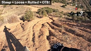
Best a few days after a rain. This is two miles of steep, rutted, loose singletrack that descend down a ridge from Main Divide to the start of Skyline trail.

Tags
DropsJumps

Local Trail Association

Traditionally Indigenous Territory

Recent Activity on Trail

Past Week
  • 1 rides
  • 23 miles average
6 Months
  • 3 rides
  • 19 miles avg distance
All
  • 31 rides
  • Last: Nov 13, 2026
c1c2c3c4
January
February
March
April
May
June
July
August
September
October
November
December
update trails status or condition

Skinsuit Trail Reports

statusdatedescription
Nov 8, 2025 @ 4:14pm (America/Los_Angeles)
Nov 8, 2025
Big ruts across all the steep spots with loose dirt.
Feb 9, 2025 @ 7:33pm
Feb 9, 2025
Perfect conditions in every way.
Nov 24, 2024 @ 3:35pm
Nov 24, 2024
Great condition. Most of the ruts have been smoothed out and is very rideable.
Mar 11, 2021 @ 6:30am
Mar 11, 2021
Snow on the top half
Dec 30, 2020 @ 5:19pm
Dec 30, 2020
Best condition ever! not overgrown, well-maintained and super steep chutes!
more »
Status:
on Nov 8, 2025
Dry
Avg: 3.69 (4 votes)
Your vote: 0

view (388)
close
      Directions to skinsuit trailhead (33.814740, -117.624430)

      Photos

      26 more »
      mtb
      217 |
      Jun 25, 2023 @ 7:38pm
      Jun 25, 2023
      mtb
      228 |
      Jun 25, 2023 @ 7:38pm
      Jun 25, 2023
      mtb
      173 |
      Mar 10, 2022 @ 11:20pm
      Mar 10, 2022
      report
      mtb
      358 |
      Jan 3, 2018 @ 9:59am
      Jan 3, 2018

      Videos

      7 more »
      This Steep, Loose, and Rutted 'Trail' in...
      mtb
      11:15 | 121 | Nov 19, 2025 , Mission Viejo
      Tinmine Conditions and Blackstar Night Ride...
      mtb
      14:10 | 88 | Jun 29, 2025 , Mission Viejo
      Tin Mine & Skinsuit Trail : MTB Sketch...
      mtb
      37:59 | 104 | Feb 11, 2025 , Mission Viejo
      Skin Suit, Corona Ca, MTB, Santa Ana Mountains
      mtb
      15:01 | 1303 | Mar 23, 2020 , Mission Viejo

      Routes with this trail

      more »
      ★ 5.0 • 30 miles • 6,178 ft • 4 • Loop •
      2024 Trans Santa Ana Enduro (B Ride / Route). This will be ~28miles and ~6,800ft of climbing. See...
      26 miles • 6,755 ft • 14 • Loop •
      Must be absolutely crazy to do this (or David Goggins) Loop can be completed in any order of downhill...
      ★ 4.0 • 42 miles • 9,757 ft • 10 • Loop • Race •
      The 2024 Trans Santa Enduro Race Course. This is expected to be ~45miles and ~10,000ft of climbing. The...
      3.3 ★★★★★
      4 Ratings
      5 ★ 25%
      4 ★ 25%
      3 ★ 25%
      2 ★
      1 ★ 25%

      4 Reviews & Comments

      highway395
      trail just GOT WOKRED ON IN CRASY GOOD CONDTION PL COME OUT ND RIDE THERE IS A !% FOOT TRACK JUMP ON HERE TO
      russscarce
      Rode this morning. Fast and technical in some. Steep downhills that you just pick a line and hope to stay out of a rut! Can’t wait to do it again.
      rideagainsthemachine rideagainsthemachine
      About three or four years ago, this trail was plowed and never regained its fun factor. If you’ve never ridden it, give it a go just to do it. It’s tame but still kinda fun mostly because it’s fast and pretty long. No gnar involved.

      We hope you've been enjoying Trailforks!

      Create a FREE account to view all trail reviews and much more.

      • By ericfoltzTF Pro TRAILFORKS & contributors
      • #45742 - 6,645 views

      Frequently Asked Questions

      ▼ Where is Skinsuit located?
      Skinsuit is located in Cleveland National Forest, Mission Viejo, California, United States. It is part of the Cleveland National Forest trail network. The trailhead is located at coordinates 33.81474, -117.62443.
      ▼ How hard is Skinsuit?
      Skinsuit is rated as Black Diamond difficulty. The physical rating is Moderate. The average grade is 16.7%. The climb difficulty is rated Double Black Diamond.
      ▼ What is the elevation gain for Skinsuit?
      Skinsuit has 64 ft of elevation gain. The trail has 2,165 ft of elevation descent. The elevation ranges from 1,202 ft to 3,303 ft.
      ▼ How long is Skinsuit?
      Skinsuit is 2.4 miles long. The trail type is singletrack.
      ▼ Are dogs allowed on Skinsuit?
      Yes, dogs are allowed on Skinsuit. Please keep dogs on a leash where required and clean up after them.
      ▼ When is the best time of year to ride Skinsuit?
      Skinsuit is best visited during: Year Round.
      ▼ How do I access Skinsuit? Where is the closest parking trailhead?
      The closest parking and trailhead locations to Skinsuit are: View all parking locations in the area.
      ▼ How long does it take to ride Skinsuit?
      Based on recorded activities, it takes an average of 13 minutes to ride Skinsuit. The trail is 2.4 miles long. Actual times will vary based on fitness level, conditions, and pace. View recent activity logs for more details.
      ▼ How busy is Skinsuit?
      Skinsuit is a moderately popular trail. There have been 392 recorded activities on this trail. The trail has received 388 check-ins. View recent activity on this trail.

      Hit the Trail

      Open in App

      Get this trail on your phone instantly.

      open trail in app

      Download Trail

      Save to wishlist, Garmin & download.
      save the trail

      Find Related Routes

      Find routes and users activities that include this trail.
      find routes for this trail

      You must enter a description before submitting.