more stats
2,923 ft
Distance
33 ft
Climb
-448 ft
Descent
2,485 ft
High Point
-414 ft
Altitude change
2,040 ft
Altitude min
2,454 ft
Altitude start
2,041 ft
Altitude end
-14.2%
Grade
-58.6%
Grade max
15.1%
Grade min
502 ft
Distance climb
2,169 ft
Distance down
253 ft
Distance flat

Space Details

  • Activities
    • Mountain Bike
    • E-Bike
  • Riding Area
    South Benson / Wolf Mountain
    Nanaimo, British Columbia
  • Difficulty Rating
  • Local Popularity
    60 in Mountain Biking [+]
    • 75 in E-Biking
  • Global Ranking
    #26295 in Mountain Biking [+]
    • #58717 in E-Biking
  • Trail Type
    Singletrack
  • Direction
    Downhill Only
    Popular Direction Shown
  • TTFs on Trail
    Bridge, Rock Face, Rock Garden, Skinny

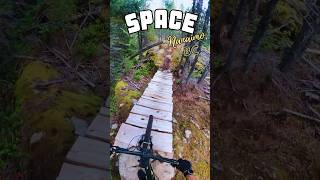
Choose from multiple paths on a shared intergalactic destiny. Ahead you will find steep rock slabs, a skinny, rock gardens, and a steep chute. At the end of the chute, Space Kittens continue straight, harnessing their stealth and agility to navigate extensive slabs and a rock wall ride. Space Bound Hounds veer right, where they will thrive on aggressive lines navigating multiple steep slabs, a step up, and a little exposure.

Access Info

Climb the Benson Summit Road to the gated left hand switchback past Meat Draw. The trail entrance is accessed off of the 4x4 gate bypass route.

This trail is unsanctioned.

Traditionally Indigenous Territory

Recent Activity on Trail

Past Week
  • 0 rides
  •  
6 Months
  • 10 rides
  • 11 miles avg distance
All
  • 43 rides
  • Last: May 31, 2026
c1c2c3c4
January
February
March
April
May
June
July
August
September
October
November
December
update trails status or condition

Space Trail Reports

statusdatedescription
Feb 5, 2026 @ 12:34pm (America/Vancouver)
Feb 5, 2026
reporter
Oct 3, 2025 @ 9:02am (America/Vancouver)
Oct 3, 2025
reporter Exit has logs in the way from road building.
Jul 7, 2025 @ 9:24am
Jul 7, 2025
May 4, 2025 @ 1:08pm
May 4, 2025
Apr 26, 2025 @ 1:33pm
Apr 26, 2025
reporter Trail condition couldnt have been better, running super.
more »
Status:
on Feb 5, 2026
Variable
Avg: 4.1 (5 votes)
Your vote: 0

view (180)
close
3D
Trail Conditions
  • Unknown
  • Snow Groomed
  • Snow Packed
  • Snow Covered
  • Snow Cover Partial
  • Freeze/thaw Cycle
  • Icy
  • Prevalent Mud
  • Wet
  • Variable
  • Ideal
  • Dry
  • Very Dry
Trail Flow (Ridden Direction)
Trailforks scans users ridelogs to determine the most popular direction each trail is ridden. A good flowing trail network will have most trails flowing in a single direction according to their intension.
The colour categories are based on what percentage of riders are riding a trail in its intended direction.
  • > 96%
  • > 90%
  • > 80%
  • > 70%
  • > 50%
  • < 50%
  • bi-directional trail
  • no data
Trail Last Ridden
Trailforks scans ridelogs to determine the last time a trail was ridden.
  • < 2 days
  • < 1 week
  • < 2 weeks
  • < 1 month
  • < 6 months
  • > 6 months
Trail Ridden Direction
The intended direction a trail should be ridden.
  • Downhill Only
  • Downhill Primary
  • Both Directions
  • Uphill Primary
  • Uphill Only
  • One Direction
Contribute Details
Colors indicate trail is missing specified detail.
  • Description
  • Photos
  • Description & Photos
  • Videos
Trail Popularity ?
Trailforks scans ridelogs to determine which trails are ridden the most in the last 9 months. Trails are compared with nearby trails in the same city region with a possible 25 colour shades. Think of this as a heatmap, more rides = more kinetic energy = warmer colors.
  • most popular
  • popular
  • less popular
  • not popular
ATV/ORV/OHV Filter
Max Vehicle Width
inches
US Cell Coverage
Legend
cell carrier legend

Radar Time
Activity Recordings
Trailforks uses anonymized public activity data. ?
Activity Recordings
Trailforks uses anonymized public activity data. ?
Personal Heatmap
Activity Types
all / none
Options
2
Date range month
Winter Trails
Warning A routing network for winter maps does not exist. Selecting trails using the winter trails layer has been disabled.
Missing Trails
Most Popular
Least Popular
Trails are colored based on popularity. The more popular a trail is, the more red. Less popular trails trend towards green.
Jump Magnitude Heatmap
Heatmap of where riders jump on trails. Zoom in to see individual jumps, click circles to view jump details.
BC Backroad Status

Service Road Atlas is a free to use, community-driven service for viewing and creating reports on the numerous back-country service roads around B.C. and Alberta.

map legend
Slope Aspect
Direction the slope faces
Flat N NE E SE S SW W NW
Trails Deemphasized
Trails are shown in grey.
disable
Only show trails with no bike usage.
Enable
Suggested Layers
Based on selected activity type

    Save the current map location and zoom level as your default home location whenever this page is loaded.

    Save
        Directions to space trailhead (49.143760, -124.030650)

        Photos

        11 more »
        130 |
        May 20, 2025 @ 11:52pm
        May 20, 2025
        146 |
        Apr 26, 2025 @ 1:38pm
        Apr 26, 2025
        178 |
        Dec 8, 2024 @ 5:10pm
        Dec 8, 2024
        160 |
        Dec 8, 2024 @ 5:09pm
        Dec 8, 2024

        Videos

        2 more »
        Space - Nanaimo, BC - MTB Trail Preview #mtb...
        0:00 | 202 | Aug 31, 2025 , Nanaimo
        First roller
        0:13 | 332 | Dec 8, 2024 , Nanaimo

        4 Reviews & Comments


        We hope you've been enjoying Trailforks!

        Create a FREE account to view trail comments and much more.

        • #806581 - 966 views

        Frequently Asked Questions About Space

        Where is Space located?
        Space is located in South Benson / Wolf Mountain, Nanaimo, British Columbia, Canada. It is part of the South Benson / Wolf Mountain trail network. The trailhead is located at coordinates 49.14376, -124.03065.
        How hard is Space?
        Space is rated as Double Black Diamond difficulty. The average grade is 14.2%.
        What is the elevation gain for Space?
        Space has 33 ft of elevation gain. The trail has 448 ft of elevation descent. The elevation ranges from 2,040 ft to 2,485 ft.
        Is Space a point to point trail?
        Yes, Space is a point to point trail. The direction is Downhill Only. The trail type is singletrack.

        Hit the Trail

        Open in App

        Get this trail on your phone instantly.
        open trail in app

        Download Trail

        Save to wishlist, Garmin & download.
        save the trail

        Find Related Routes

        Find routes and users activities that include this trail.
        find routes for this trail

        You must enter a description before submitting.