more stats
3.1 miles
Distance
40 ft
Climb
-1,156 ft
Descent
00:21:04
Avg time
-1,115 ft
Altitude change
1,288 ft
Altitude min
2,410 ft
Altitude max
2,404 ft
Altitude start
1,289 ft
Altitude end
-6.8%
Grade
-29.9%
Grade max
14.9%
Grade min
945 ft
Distance climb
3 miles
Distance down
1,145 ft
Distance flat
00:21:04
Avg time

Split Enz Details

  • Activities
    • Mountain Bike
    • E-Bike
  • Riding Area
  • Difficulty Rating
  • Voted Difficulty
    Blue (4 votes)
  • Local Popularity
    85 in Mountain Biking [+]
    • 80 in E-Biking
  • Global Ranking
    #268 in Mountain Biking [+]
    • #2087 in E-Biking
  • Trail Type
    Singletrack
  • Bike Type
    AM, XC
  • Direction
    Downhill Only
    Popular Direction Shown
  • Climb Difficulty
    Green
  • Physical Rating
    Easy
  • Trail Visibility
    Always easy to follow
  • Dogs Allowed
    Yes
  • eBike Allowed
    Yes up to Class 1
  • TTFs on Trail
    Berm
  • Ride in Rain
    Yes

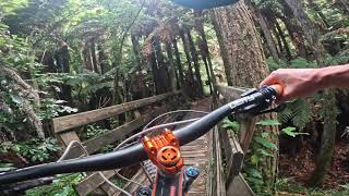
The new Split Enz after the harvest, rebuilt with a new start location. Staying true to the nature of the trail that made it many rider's favourite back in 2007, the Rotorua Trails Trust rebuilt version retains the mellow, flowing style of the original. It is far longer though, with an insightful reading of the contours by the trail builders to milk as much distance and smoothness from the terrain as possible.
There’s a gentle descent the entire length of the trail - so little need for pedalling input. Riders are more likely to need to take a rest to ease their aching arms and sore faces from so much smiling on the long ride down
Although many corners have a consistent sweeping bend, there is the occasional turn that is a little tighter and requires riders to feather their brakes to roll around. Just enough to keep things interesting and make sure you're paying attention.
After the 2020-21 harvesting of Pondy New, Split Enz was extended to flow through the old Pondy area all the way to Roller Coaster, making it the longest trail in Whakarewarewa Forest. The open areas of this trail can succumb to frost damage, so please avoid when frosty.

Access Info

Accessed by the Time Warp climb from the summit of the Moerangi Road saddle. The view from the start of the trail currently wins the prize of the best view in the forest – a panorama including Green Lake, Mt Ruapehu and Rotorua City and the lake, worth an extended rest (there’s even a park bench up there) on a good day after the long climb

Local Trail Association

Recent Activity on Trail

Past Week
  • 4 rides
  • 21 miles average
6 Months
  • 159 rides
  • 22 miles avg distance
All
  • 1,621 rides
  • Last: May 29, 2026
c1c2c3c4
January
February
March
April
May
June
July
August
September
October
November
December
update trails status or condition

Split Enz Trail Reports

statusdatedescription
May 23, 2026 @ 12:36pm (Pacific/Auckland)
May 22, 2026
Rough on a HT SS 😜
Apr 15, 2026 @ 4:40pm (Pacific/Auckland)
Apr 14, 2026
Small Tree across the track, lower split ends just before the 100 sign.
Apr 11, 2026 @ 7:13am (Pacific/Auckland)
Apr 10, 2026
Some cool tidy ups on some berms. Running fast.
Jan 3, 2026 @ 12:10am (Pacific/Auckland)
Jan 2, 2026
Riding really well, even after the wet weather. The rebuilt section without braking bumps is great!
Dec 28, 2025 @ 6:21pm (Pacific/Auckland)
Dec 27, 2025
more »
Status:
on May 23, 2026
Ideal
Avg: 4.42 (53 votes)
Your vote: 0

view (11,904)
close
3D
Trail Conditions
  • Unknown
  • Snow Groomed
  • Snow Packed
  • Snow Covered
  • Snow Cover Partial
  • Freeze/thaw Cycle
  • Icy
  • Prevalent Mud
  • Wet
  • Variable
  • Ideal
  • Dry
  • Very Dry
Trail Flow (Ridden Direction)
Trailforks scans users ridelogs to determine the most popular direction each trail is ridden. A good flowing trail network will have most trails flowing in a single direction according to their intension.
The colour categories are based on what percentage of riders are riding a trail in its intended direction.
  • > 96%
  • > 90%
  • > 80%
  • > 70%
  • > 50%
  • < 50%
  • bi-directional trail
  • no data
Trail Last Ridden
Trailforks scans ridelogs to determine the last time a trail was ridden.
  • < 2 days
  • < 1 week
  • < 2 weeks
  • < 1 month
  • < 6 months
  • > 6 months
Trail Ridden Direction
The intended direction a trail should be ridden.
  • Downhill Only
  • Downhill Primary
  • Both Directions
  • Uphill Primary
  • Uphill Only
  • One Direction
Contribute Details
Colors indicate trail is missing specified detail.
  • Description
  • Photos
  • Description & Photos
  • Videos
Trail Popularity ?
Trailforks scans ridelogs to determine which trails are ridden the most in the last 9 months. Trails are compared with nearby trails in the same city region with a possible 25 colour shades. Think of this as a heatmap, more rides = more kinetic energy = warmer colors.
  • most popular
  • popular
  • less popular
  • not popular
ATV/ORV/OHV Filter
Max Vehicle Width
inches
US Cell Coverage
Legend
cell carrier legend

Radar Time
Activity Recordings
Trailforks uses anonymized public activity data. ?
Activity Recordings
Trailforks uses anonymized public activity data. ?
Personal Heatmap
Activity Types
all / none
Options
2
Date range month
Winter Trails
Warning A routing network for winter maps does not exist. Selecting trails using the winter trails layer has been disabled.
Missing Trails
Most Popular
Least Popular
Trails are colored based on popularity. The more popular a trail is, the more red. Less popular trails trend towards green.
Jump Magnitude Heatmap
Heatmap of where riders jump on trails. Zoom in to see individual jumps, click circles to view jump details.
BC Backroad Status

Service Road Atlas is a free to use, community-driven service for viewing and creating reports on the numerous back-country service roads around B.C. and Alberta.

map legend
Slope Aspect
Direction the slope faces
Flat N NE E SE S SW W NW
Trails Deemphasized
Trails are shown in grey.
disable
Only show trails with no bike usage.
Enable
Suggested Layers
Based on selected activity type

    Save the current map location and zoom level as your default home location whenever this page is loaded.

    Save
        Directions to split-enz trailhead (-38.198060, 176.309150)

        Photos

        47 more »
        101 |
        Mar 7, 2023 @ 8:41pm
        Mar 7, 2023
        83 |
        Mar 7, 2023 @ 8:41pm
        Mar 7, 2023
        82 |
        Mar 7, 2023 @ 8:41pm
        Mar 7, 2023
        79 |
        Mar 7, 2023 @ 8:41pm
        Mar 7, 2023

        Videos

        17 more »
        youtuber Shuttlin’ in Style - Riding Split Enz @...
        14:43 | 772 | Mar 18, 2019 , Rotorua
        youtuber Eagle vs Blackhouse - Getting the best view in...
        6:57 | 246 | Nov 8, 2021 , Rotorua
        youtuber THIS is why I flew halfway around the world to...
        14:55 | 810 | Feb 18, 2019 , Rotorua
        youtuber Split Enz @ whakarewarewa Forest. Rotorua
        13:06 | 263 | Nov 18, 2024 , Rotorua

        Trail Lists

        Routes with this trail

        4.0 18 miles 3,050 ft 42 Loop
        A good intermediate - upper intermediate loop. A couple of good solid climbs but you will always be...
        5.0 41 miles 6,016 ft 36
        Course for 63km Highlander Geyser to Lake
        4.0 20 miles 3,451 ft 22 Loop
        Checking out Top and

        7 Reviews & Comments


        We hope you've been enjoying Trailforks!

        Create a FREE account to view trail comments and much more.

        • By nduroeventsTF Pro & contributors
        • #68130 - 14,061 views

        Frequently Asked Questions About Split Enz

        Where is Split Enz located?
        Split Enz is located in Whakarewarewa Forest, Rotorua, New Zealand. It is part of the Whakarewarewa Forest trail network. The trailhead is located at coordinates -38.19806, 176.30915.
        How hard is Split Enz?
        Split Enz is rated as Blue difficulty. The physical rating is Easy. The average grade is 6.8%. The climb difficulty is rated Green.
        What is the elevation gain for Split Enz?
        Split Enz has 40 ft of elevation gain. The trail has 1,156 ft of elevation descent. The elevation ranges from 1,288 ft to 2,410 ft.
        Is Split Enz a point to point trail?
        Yes, Split Enz is a point to point trail. The direction is Downhill Only. The trail type is singletrack.

        Hit the Trail

        Open in App

        Get this trail on your phone instantly.
        open trail in app

        Download Trail

        Save to wishlist, Garmin & download.
        save the trail

        Find Related Routes

        Find routes and users activities that include this trail.
        find routes for this trail

        You must enter a description before submitting.