more stats
1.8 miles
Distance
703 ft
Climb
-69 ft
Descent
00:34:40
Avg time
632 ft
Altitude change
492 ft
Altitude min
1,151 ft
Altitude max
516 ft
Altitude start
1,148 ft
Altitude end
6.6%
Grade
-10%
Grade max
55.1%
Grade min
1 mile
Distance climb
1,778 ft
Distance down
610 ft
Distance flat
00:34:40
Avg time

Trail Details

  • Activities
    • Mountain Bike
    • E-Bike
    • Hike
    • Trail Running
  • Riding Area
    Terrace Mountain
    Terrace, British Columbia
  • AKA
    Spring Creek
  • Difficulty Rating
  • Voted Difficulty
    Blue (1 vote)
  • Local Popularity
    100 in Mountain Biking [+]
    • 100 in E-Biking
    • 90 in Trail Running
    • 100 in Hiking
  • Global Ranking
    #34427 in Mountain Biking [+]
    • #5162 in E-Biking
    • #34658 in Trail Running
    • #22536 in Hiking
  • Trail Type
    Singletrack
  • Bike Type
    AM, XC
  • Climb Difficulty
    Blue
  • Physical Rating
    Moderate
  • Trail Visibility
    Always easy to follow
  • Season
    summer,fall,spring
  • Dogs Allowed
    Yes
  • eBike Allowed
    Yes up to Class 1
  • TTFs on Trail
    Bridge
  • Ride in Rain
    Yes
  • Year Opened
    2013

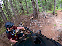
A Terrace favourite trail. Steinhoe Ridge Trail from the Spring Creek side is an excellent climb with some technical, punchy sections and some flow to help you catch your breath. This trail is the next progression in skill level/difficulty from Hey Bear in the trail network.

Access Info

Now accessed via the Spring Creek Climb Connector beginning in the parking lot. Exit to Spring Creek road via the Spring Creek Exit trail.

Trail Supporters
Local Trail Association
Traditionally Indigenous Territory

Recent Activity on Trail

Past Week
  • 3 rides
  • 8 miles average
6 Months
  • 41 rides
  • 8 miles avg distance
All
  • 1,270 rides
  • Last: Jun 22, 2026
c1c2c3c4
January
February
March
April
May
June
July
August
September
October
November
December
update trails status or condition

Spring Creek (to... Trail Reports

statusdatedescription
Apr 22, 2026 @ 6:50am (America/Vancouver)
Apr 22, 2026
reporter Raked top to bottom. A couple areas of winter damage that will need to be repaired, but other than that, running great!
Apr 11, 2026 @ 3:34pm (America/Vancouver)
Apr 11, 2026
reporter Raked up to the Y. A few sections that will need some repairs but should pedal great. Watch for debris after the Y!
Apr 4, 2026 @ 8:52pm (America/Vancouver)
Apr 4, 2026
reporter Icy at the bottom. Prevalent snow, especially in the upper half of trail. Photo from near the Y on April 1st.
Mar 6, 2026 @ 6:51pm (America/Vancouver)
Mar 6, 2026
reporter Peanut butter
Feb 14, 2026 @ 2:31pm (America/Vancouver)
Feb 14, 2026
reporter A few soft spots. There's still a bit of ice on the approach to the bridge at the trailhead. Otherwise, the trail was running pretty great. Expect...
more »
Status:
on Apr 22, 2026
Ideal
Avg: 4.35 (11 votes)
Your vote: 0

view (8,557)
close
3D
Trail Conditions
  • Unknown
  • Snow Groomed
  • Snow Packed
  • Snow Covered
  • Snow Cover Partial
  • Freeze/thaw Cycle
  • Icy
  • Prevalent Mud
  • Wet
  • Variable
  • Ideal
  • Dry
  • Very Dry
Trail Flow (Ridden Direction)
Trailforks scans users ridelogs to determine the most popular direction each trail is ridden. A good flowing trail network will have most trails flowing in a single direction according to their intension.
The colour categories are based on what percentage of riders are riding a trail in its intended direction.
  • > 96%
  • > 90%
  • > 80%
  • > 70%
  • > 50%
  • < 50%
  • bi-directional trail
  • no data
Trail Last Ridden
Trailforks scans ridelogs to determine the last time a trail was ridden.
  • < 2 days
  • < 1 week
  • < 2 weeks
  • < 1 month
  • < 6 months
  • > 6 months
Trail Ridden Direction
The intended direction a trail should be ridden.
  • Downhill Only
  • Downhill Primary
  • Both Directions
  • Uphill Primary
  • Uphill Only
  • One Direction
Contribute Details
Colors indicate trail is missing specified detail.
  • Description
  • Photos
  • Description & Photos
  • Videos
Trail Popularity ?
Trailforks scans ridelogs to determine which trails are ridden the most in the last 9 months. Trails are compared with nearby trails in the same city region with a possible 25 colour shades. Think of this as a heatmap, more rides = more kinetic energy = warmer colors.
  • most popular
  • popular
  • less popular
  • not popular
ATV/ORV/OHV Filter
Max Vehicle Width
inches
US Cell Coverage
Legend
cell carrier legend

Radar Time
Activity Recordings
Trailforks uses anonymized public activity data. ?
Activity Recordings
Trailforks uses anonymized public activity data. ?
Personal Heatmap
Activity Types
all / none
Options
2
Date range month
Winter Trails
Warning A routing network for winter maps does not exist. Selecting trails using the winter trails layer has been disabled.
Missing Trails
Most Popular
Least Popular
Trails are colored based on popularity. The more popular a trail is, the more red. Less popular trails trend towards green.
Jump Magnitude Heatmap
Heatmap of where riders jump on trails. Zoom in to see individual jumps, click circles to view jump details.
BC Backroad Status

Service Road Atlas is a free to use, community-driven service for viewing and creating reports on the numerous back-country service roads around B.C. and Alberta.

map legend
Slope Aspect
Direction the slope faces
Flat N NE E SE S SW W NW
Trails Deemphasized
Trails are shown in grey.
disable
Only show trails with no bike usage.
Enable
Suggested Layers
Based on selected activity type

    Save the current map location and zoom level as your default home location whenever this page is loaded.

    Save
        Directions to spring-creek-to-steinhoe trailhead (54.561910, -128.594780)

        Photos

        102 more »
        113 |
        Aug 27, 2022 @ 3:50pm
        Aug 27, 2022
        94 |
        Aug 27, 2022 @ 3:50pm
        Aug 27, 2022
        73 |
        Aug 27, 2022 @ 3:50pm
        Aug 27, 2022
        80 |
        Aug 27, 2022 @ 3:50pm
        Aug 27, 2022

        Videos

        1 more »
        Noob descent Lichen Steinhoe
        14:21 | 173 | Jun 18, 2020 , Terrace

        Trail Lists

        Routes with this trail

        5 miles 916 ft 4
        This is the go-to quick after work pedal loop. Usually takes most people an hour or less.
        4.0 4 miles 870 ft 4 Loop
        Popular route to session Shangri-La, good times all-round. Begins with a demanding climb up Steinhoe...
        6 miles 1,290 ft 6 Point to Point
        Easiest route to collect 5 cards for a poker hand for the 2018 Rusty Chain Poker Ride presented by TORCA....

        1 Review & Comments


        We hope you've been enjoying Trailforks!

        Create a FREE account to view trail comments and much more.

        • By SharonbTF Pro Cypress & contributors
        • #8130 - 15,156 views

        Frequently Asked Questions About Spring Creek (to Steinhoe)

        Where is Spring Creek (to Steinhoe) located?
        Spring Creek (to Steinhoe) is located in Terrace Mountain, Terrace, British Columbia, Canada. It is part of the Terrace Mountain trail network. The trailhead is located at coordinates 54.56191, -128.59478.
        How hard is Spring Creek (to Steinhoe)?
        Spring Creek (to Steinhoe) is rated as Blue difficulty. The physical rating is Moderate. The average grade is 6.6%. The climb difficulty is rated Blue.
        What is the elevation gain for Spring Creek (to Steinhoe)?
        Spring Creek (to Steinhoe) has 703 ft of elevation gain. The trail has 69 ft of elevation descent. The elevation ranges from 492 ft to 1,151 ft.
        How long is Spring Creek (to Steinhoe)?
        Spring Creek (to Steinhoe) is 1.8 miles long. The trail type is singletrack.

        Hit the Trail

        Open in App

        Get this trail on your phone instantly.
        open trail in app

        Download Trail

        Save to wishlist, Garmin & download.
        save the trail

        Find Related Routes

        Find routes and users activities that include this trail.
        find routes for this trail

        You must enter a description before submitting.