
more stats
1,109 ft
Distance
-98 ft
Descent
00:01:15
Avg time
-98 ft
Altitude change
77 ft
Altitude min
175 ft
Altitude max
175 ft
Altitude start
79 ft
Altitude end
-8.8%
Grade
-22.6%
Grade max
-2.4%
Grade min
1,109 ft
Distance down
00:01:15
Avg time

Stenbocken Details

  • Activities
    • Mountain Bike
    • Hike
    • Trail Running
  • Riding Area
    Görväln
    Järfälla
  • Difficulty Rating
  • Local Popularity
    40 in Mountain Biking heatmap [+]
    • 5 in Trail Running
    • 5 in Hiking
  • Global Ranking
    #31221 in Mountain Biking [+]
    • #326944 in Trail Running
    • #352433 in Hiking
  • National Ranking
    #1,054 in Mountain Biking · Sweden [+]
    • #28,327 in Trail Running
    • #23,193 in Hiking
  • Trail Type
    Singletrack
  • Bike Type
    AM, XC
  • Direction
    Downhill Primary
    Popular Direction Shown
  • Climb Difficulty
    Black Diamond
  • Physical Rating
    Moderate
  • Trail Visibility
    No clear path
  • Dogs Allowed
    Yes
  • eBike Allowed
  • TTFs on Trail
    Drop, Rock Face, Rock Garden

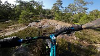
Stigen startar en bit in på Bergsgeten. Efter första skogspartiet och sedan när man är uppe på hällarna så tar man direkt till höger och följer nedfarten som går delvis på skråiga hällar ner i en stenkista. Sedan är det svårare att navigera sig - håll rådjursstigen rakt fram förbi stenröset till nästa skogsparti. Här dimper man in mellan två träd i en naturlig skogsgata och följer rådjursstigen en biten in den börjar svänga av mot vänster upp på ett annat hällparti. Väl uppe på dessa hällar håller man rakt fram och neråt - här kommer det trixiga. Det finns olika varianter ner, en är rakt fram i en tajt hälrullning med en hel del mossa och ett träd håll linjen tills man är nere på den nedre klacken. Här är det en 90 graders sväng ner till vänster för en snabb rullning ner i ett skogsparti. Håll rakt fram och sedan ner för en klack igen, trixa dig till vänster förbi ett träd och sen sten i den sista lilla rullningen ner i skogsparti som tar dig till cykelbanan.

Tags

Recent Activity on Trail

Past Week
  • 0 rides
  •  
6 Months
  • 2 rides
  • 6 miles avg distance
All
  • 155 rides
  • Last: Jun 21, 2026
c1c2c3c4
January
February
March
April
May
June
July
August
September
October
November
December
update trails status or condition

Stenbocken Trail Reports

Status:
on Apr 15, 2023
Ideal
Avg: 3.99 (2 votes)
Your vote: 0

view (221)
close
      Directions to stenbocken trailhead (59.414650, 17.768410)

      Photos

      4 more »
      mtb
      107 |
      Mar 29, 2021 @ 4:24am
      Mar 29, 2021
      mtb
      85 |
      Dec 19, 2020 @ 5:27am
      Dec 19, 2020
      mtb
      62 |
      Dec 19, 2020 @ 5:27am
      Dec 19, 2020
      mtb
      91 |
      Dec 19, 2020 @ 5:27am
      Dec 19, 2020

      Videos

      1 more »
      MTB - Görväln - Stenbocken
      mtb
      3:01 | 102 | Jun 10, 2023 , Järfälla
      4.0 ★★★★★
      2 Ratings
      5 ★
      4 ★ 100%
      3 ★
      2 ★
      1 ★

      Reviews / Comments

      No reviews yet, be the first to write a review or ask a question.
      Use trail reports to comment on trail conditions.


      We hope you've been enjoying Trailforks!

      Create a FREE account to view all trail reviews and much more.

      • By ManneblaskTF Pro & contributors
      • #378299 - 682 views

      Frequently Asked Questions

      ▼ Where is Stenbocken located?
      Stenbocken is located in Görväln, Järfälla, Sweden. It is part of the Görväln trail network. The trailhead is located at coordinates 59.41465, 17.76841.
      ▼ How hard is Stenbocken?
      Stenbocken is rated as Red difficulty. The physical rating is Moderate. The average grade is 8.8%. The climb difficulty is rated Black Diamond.
      ▼ What is the elevation gain for Stenbocken?
      The trail has 98 ft of elevation descent. The elevation ranges from 77 ft to 175 ft.
      ▼ Is Stenbocken a point to point trail?
      Stenbocken is not a point to point trail. The direction is Downhill Primary. The trail type is singletrack.
      ▼ How long is Stenbocken?
      Stenbocken is 1,109 ft long. The trail type is singletrack.
      ▼ Are dogs allowed on Stenbocken?
      Yes, dogs are allowed on Stenbocken. Please keep dogs on a leash where required and clean up after them.
      ▼ When is the best time of year to ride Stenbocken?
      Based on activity log data, the most popular months to ride Stenbocken are:
      • June (5 activities)
      • May (4 activities)
      • March (2 activities)
      Check the reports page for current trail conditions.
      ▼ How do I access Stenbocken? Where is the closest parking trailhead?
      The closest parking and trailhead locations to Stenbocken are: View all parking locations in the area.
      ▼ How long does it take to ride Stenbocken?
      Based on recorded activities, it takes an average of 1 minute to ride Stenbocken. The trail is 1,109 ft long. Actual times will vary based on fitness level, conditions, and pace. View recent activity logs for more details.
      ▼ How busy is Stenbocken?
      Stenbocken is a moderately popular trail. There have been 211 recorded activities on this trail. The trail has received 221 check-ins. View recent activity on this trail.

      Hit the Trail

      Open in App

      Get this trail on your phone instantly.

      open trail in app

      Download Trail

      Save to wishlist, Garmin & download.
      save the trail

      Find Related Routes

      Find routes and users activities that include this trail.
      find routes for this trail

      You must enter a description before submitting.

