more stats
3,123 ft
Distance
-402 ft
Descent
00:14:44
Avg time
-402 ft
Altitude change
720 ft
Altitude min
1,122 ft
Altitude max
1,122 ft
Altitude start
722 ft
Altitude end
-12.9%
Grade
-36.8%
Grade max
-2.5%
Grade min
3,094 ft
Distance down
30 ft
Distance flat
00:14:44
Avg time

Step Details

  • Activities
    • Mountain Bike
    • E-Bike
    • Hike
    • Trail Running
  • Riding Area
    Dealul Şomleu
    Sânmartin
  • Difficulty Rating
  • Local Popularity
    100 in Mountain Biking [+]
    • 5 in E-Biking
    • 5 in Trail Running
    • 5 in Hiking
  • Global Ranking
    #75261 in Mountain Biking [+]
    • #147698 in Trail Running
    • #142883 in Hiking
  • Trail Type
    Singletrack
  • Bike Type
    DH, AM, XC
  • Climb Difficulty
    Black Diamond
  • Physical Rating
    Easy
  • Season
    Mar - Nov
  • Dogs Allowed
    Yes
  • eBike Allowed
    Yes up to Class 1
  • TTFs on Trail
    Berm, Drop, Jump, Gap Jump

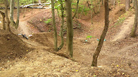
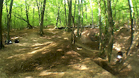
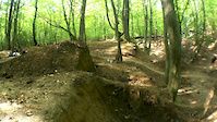
One of the best trails at Crater, with a lot of TTF's along it. It starts with a straight section through a little off-camber sprinkled with some roots. It then goes into some tight turns, located one after another. The middle section has a lot of jumps, of varied sizes, with gaps up to 10 meters. It ends through a steep ditch which is probably the most technical part of the trail.

Access Info

From the observatory tower, it's marked at the beginning

Recent Activity on Trail

Past Week
  • 0 rides
  •  
6 Months
  • 5 rides
  • 16 miles avg distance
All
  • 23 rides
  • Last: May 28, 2026
c1c2c3c4
January
February
March
April
May
June
July
August
September
October
November
December
update trails status or condition

Step Trail Reports

statusdatedescription
Oct 12, 2025 @ 2:11pm (Europe/Budapest)
Oct 12, 2025
Oct 12, 2025 @ 10:24am (Europe/Budapest)
Oct 12, 2025
Feb 21, 2021 @ 2:17am
Feb 21, 2021
Sep 24, 2020 @ 8:51am
Sep 24, 2020
reporter
Oct 19, 2019 @ 12:09am
Oct 19, 2019
lots of leaves cover the trail thus one cannot follow the line unless they know it before hand
more »
Status:
on Oct 12, 2025
Ideal
Avg: 4.11 (2 votes)
Your vote: 0

view (84)
close
3D
Trail Conditions
  • Unknown
  • Snow Groomed
  • Snow Packed
  • Snow Covered
  • Snow Cover Partial
  • Freeze/thaw Cycle
  • Icy
  • Prevalent Mud
  • Wet
  • Variable
  • Ideal
  • Dry
  • Very Dry
Trail Flow (Ridden Direction)
Trailforks scans users ridelogs to determine the most popular direction each trail is ridden. A good flowing trail network will have most trails flowing in a single direction according to their intension.
The colour categories are based on what percentage of riders are riding a trail in its intended direction.
  • > 96%
  • > 90%
  • > 80%
  • > 70%
  • > 50%
  • < 50%
  • bi-directional trail
  • no data
Trail Last Ridden
Trailforks scans ridelogs to determine the last time a trail was ridden.
  • < 2 days
  • < 1 week
  • < 2 weeks
  • < 1 month
  • < 6 months
  • > 6 months
Trail Ridden Direction
The intended direction a trail should be ridden.
  • Downhill Only
  • Downhill Primary
  • Both Directions
  • Uphill Primary
  • Uphill Only
  • One Direction
Contribute Details
Colors indicate trail is missing specified detail.
  • Description
  • Photos
  • Description & Photos
  • Videos
Trail Popularity ?
Trailforks scans ridelogs to determine which trails are ridden the most in the last 9 months. Trails are compared with nearby trails in the same city region with a possible 25 colour shades. Think of this as a heatmap, more rides = more kinetic energy = warmer colors.
  • most popular
  • popular
  • less popular
  • not popular
ATV/ORV/OHV Filter
Max Vehicle Width
inches
US Cell Coverage
Legend
cell carrier legend

Radar Time
Activity Recordings
Trailforks uses anonymized public activity data. ?
Activity Recordings
Trailforks uses anonymized public activity data. ?
Personal Heatmap
Activity Types
all / none
Options
2
Date range month
Winter Trails
Warning A routing network for winter maps does not exist. Selecting trails using the winter trails layer has been disabled.
Missing Trails
Most Popular
Least Popular
Trails are colored based on popularity. The more popular a trail is, the more red. Less popular trails trend towards green.
Jump Magnitude Heatmap
Heatmap of where riders jump on trails. Zoom in to see individual jumps, click circles to view jump details.
BC Backroad Status

Service Road Atlas is a free to use, community-driven service for viewing and creating reports on the numerous back-country service roads around B.C. and Alberta.

map legend
Slope Aspect
Direction the slope faces
Flat N NE E SE S SW W NW
Trails Deemphasized
Trails are shown in grey.
disable
Only show trails with no bike usage.
Enable
Suggested Layers
Based on selected activity type

    Save the current map location and zoom level as your default home location whenever this page is loaded.

    Save
        Directions to step trailhead (46.983370, 22.022860)

        Photos

        4 more »
        282 |
        May 15, 2017 @ 9:38am
        May 15, 2017
        226 |
        May 15, 2017 @ 9:38am
        May 15, 2017
        205 |
        May 15, 2017 @ 9:38am
        May 15, 2017
        220 |
        May 15, 2017 @ 9:38am
        May 15, 2017

        Videos

        3 more »
        Step-it-up
        0:05 | 235 | Nov 11, 2013 , Sânmartin
        Step-it up!
        0:03 | 302 | Nov 11, 2013 , Sânmartin
        Step-it up!!
        0:03 | 170 | Nov 11, 2013 , Sânmartin

        Reviews / Comments

        No reviews yet, be the first to write a review or ask a question.
        Use trail reports to comment on trail conditions.


        We hope you've been enjoying Trailforks!

        Create a FREE account to view trail comments and much more.

        • By pufalotTF Pro TRAILFORKS & contributors
        • #90463 - 950 views

        Frequently Asked Questions About Step

        Where is Step located?
        Step is located in Dealul Şomleu, Sânmartin, Romania. It is part of the Dealul Şomleu trail network. The trailhead is located at coordinates 46.98337, 22.02286.
        How hard is Step?
        Step is rated as Red difficulty. The physical rating is Easy. The average grade is 12.9%. The climb difficulty is rated Black Diamond.
        What is the elevation gain for Step?
        The trail has 402 ft of elevation descent. The elevation ranges from 720 ft to 1,122 ft.
        How long is Step?
        Step is 3,123 ft long. The trail type is singletrack.

        Hit the Trail

        Open in App

        Get this trail on your phone instantly.
        open trail in app

        Download Trail

        Save to wishlist, Garmin & download.
        save the trail

        Find Related Routes

        Find routes and users activities that include this trail.
        find routes for this trail

        You must enter a description before submitting.