


more stats
818 ft
Distance
-148 ft
Descent
00:01:13
Avg time
-148 ft
Altitude change
4,907 ft
Altitude min
5,055 ft
Altitude max
5,055 ft
Altitude start
4,907 ft
Altitude end
-18.055%
Grade
-25.323%
Grade max
727 ft
Distance down
91 ft
Distance flat
00:01:13
Avg time

T2 Details

  • Activities
    • Mountain Bike
    • E-Bike
    • Hike
    • Trail Running
  • Riding Area
    Canmore Nordic Centre
    Canmore, Alberta
  • Difficulty Rating
  • Local Popularity
    85 in Mountain Biking heatmap [+]
    • 80 in E-Biking
    • 70 in Trail Running
    • 5 in Hiking
  • Global Ranking
    #36723 in Mountain Biking [+]
    • #29391 in E-Biking
    • #138692 in Trail Running
    • #330043 in Hiking
  • Provincial Ranking
    #618 in Mountain Biking · Alberta [+]
    • #368 in E-Biking
    • #2,581 in Trail Running
    • #4,725 in Hiking
  • Trail Type
    Singletrack
  • Bike Type
    AM, XC
  • Direction
    Downhill Primary
  • Climb Difficulty
    Black Diamond
  • Physical Rating
    Hard
  • Season
    May-Oct
  • Dogs Allowed
    Yes
  • eBike Allowed
  • Land Owner

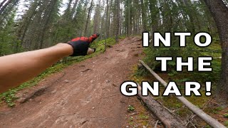
2 steep sections with multiple lines. 2nd one is off camber and difficult when wet

Access Info

From Odyssey singletrack, Rundle or Wolverine ski trails

Tags

Recent Activity on Trail

Past Week
  • 4 rides
  • 15.6 km average
6 Months
  • 177 rides
  • 21.9 km avg distance
All
  • 907 rides
  • Last: Nov 14, 2026
c1c2c3c4
January
February
March
April
May
June
July
August
September
October
November
December
Status:
on Sep 6, 2026
Ideal
Avg: 3.87 (10 votes)
Your vote: 0

view (5,530)
close
      Directions to t2-32886 trailhead (51.110430, -115.416590)

      Photos

      3 more »
      mtb
      T2
      1,019 |
      Jul 19, 2016 @ 10:14am
      Jul 19, 2016
      mtb
      T2
      451 |
      May 28, 2016 @ 10:37pm
      May 28, 2016
      mtb
      T2
      433 |
      May 28, 2016 @ 10:36pm
      May 28, 2016

      Videos

      3 more »
      youtuber Canmore Enduro 2024 (Steedz)
      mtb
      26:31 | 401 | Feb 8, 2025 , Canmore
      Rubber sandals work best for the podium shoey
      mtb
      21:11 | 10 | Jul 21, 2026 , Canmore
      youtuber Into The Gnar at Canmore Nordic Centre
      mtb
      17:39 | 637 | Jul 16, 2021 , Canmore

      Routes with this trail

      more »
      16 miles • 2,753 ft • 24 •
      Canmore Women's Enduro 2025 Long Course Stage 1: Odyssey + T2 (A Line: T2, B Line: Odyssey) Stage 2: Soft...
      13 miles • 2,638 ft • 23 •
      Canmore Women's Enduro Black Course 2024
      ★ 1.0 • 162 miles • 19,314 ft • 106 • Loop •
      Think you've got what it takes to tackle this monster ride? This is the ultimate link-up of single track...
      3.8 ★★★★★
      10 Ratings
      5 ★ 20%
      4 ★ 60%
      3 ★ 10%
      2 ★
      1 ★ 10%

      2 Reviews & Comments

      ChossSW5dcZ
      Some pretty steep slopes littered with roots. A good exercise in tech, line choice and breaking but I don't think it's more fun than Odessey
      chasingjoy chasingjoy
      Your better have good brake control, slow speed control, expert line selection and some comfort on long rooty descents.

      I've been riding Squamish and North Shor over past 6 months and this is among those top janky trails. LOVE IT

      We hope you've been enjoying Trailforks!

      Create a FREE account to view all trail reviews and much more.

      • By racerfacerTF Pro & contributors
      • #32886 - 3,495 views

      Frequently Asked Questions

      ▼ Where is T2 located?
      T2 is located in Canmore Nordic Centre, Canmore, Alberta, Canada. It is part of the Canmore Nordic Centre trail network. The trailhead is located at coordinates 51.11043, -115.41659.
      ▼ How hard is T2?
      T2 is rated as Black Diamond difficulty. The physical rating is Hard. The average grade is 18.055%. The climb difficulty is rated Black Diamond.
      ▼ What is the elevation gain for T2?
      The trail has 148 ft of elevation descent. The elevation ranges from 4,907 ft to 5,055 ft.
      ▼ Is T2 a point to point trail?
      T2 is not a point to point trail. The direction is Downhill Primary. The trail type is singletrack.
      ▼ How long is T2?
      T2 is 818 ft long. The trail type is singletrack.
      ▼ Are dogs allowed on T2?
      Yes, dogs are allowed on T2. Please keep dogs on a leash where required and clean up after them.
      ▼ When is the best time of year to ride T2?
      Based on activity log data, the most popular months to ride T2 are:
      • July (120 activities)
      • June (66 activities)
      • August (62 activities)
      Check the reports page for current trail conditions.
      ▼ How do I access T2? Where is the closest parking trailhead?
      The closest parking and trailhead locations to T2 are: View all parking locations in the area.
      ▼ How long does it take to ride T2?
      Based on recorded activities, it takes an average of 1 minute to ride T2. The trail is 818 ft long. Actual times will vary based on fitness level, conditions, and pace. View recent activity logs for more details.
      ▼ How busy is T2?
      T2 is a very popular trail. There have been 5,500 recorded activities on this trail. The trail has received 5,530 check-ins. View recent activity on this trail.

      Hit the Trail

      Open in App

      Get this trail on your phone instantly.

      open trail in app

      Download Trail

      Save to wishlist, Garmin & download.
      save the trail

      Find Related Routes

      Find routes and users activities that include this trail.
      find routes for this trail

      You must enter a description before submitting.

