

more stats
4,259 ft
Distance
151 ft
Climb
-44 ft
Descent
00:11:36
Avg time
107 ft
Altitude change
3,842 ft
Altitude min
3,970 ft
Altitude max
3,847 ft
Altitude start
3,953 ft
Altitude end
2.5%
Grade
-9.1%
Grade max
28.8%
Grade min
2,454 ft
Distance climb
1,020 ft
Distance down
784 ft
Distance flat
00:11:36
Avg time

Tech Ridge Details

  • Activities
    • Mountain Bike
    • E-Bike
    • Horse
    • Hike
    • Trail Running
  • Riding Area
    Monolith Gardens
    Kingman, Arizona
  • Difficulty Rating
  • Voted Difficulty
    Blue (1 vote)
  • Local Popularity
    60 in Mountain Biking [+]
    • 5 in E-Biking
    • 5 in Trail Running
    • 5 in Hiking
    • 5 in Horseback
  • Global Ranking
    #109492 in Mountain Biking [+]
    • #221396 in E-Biking
    • #342021 in Trail Running
    • #367272 in Hiking
    • #31412 in Horseback
  • State Ranking
    #1,595 in Mountain Biking · Arizona [+]
    • #1,331 in E-Biking
    • #4,554 in Trail Running
    • #5,101 in Hiking
    • #1,201 in Horseback
  • Trail Type
    Singletrack
  • Bike Type
    XC
  • Direction
    Both Directions
  • Climb Difficulty
    Blue
  • Physical Rating
    Moderate
  • Trail Visibility
    Always easy to follow
  • Dogs Allowed
    Yes
  • eBike Allowed
    Yes up to Class 1
  • Land Owner

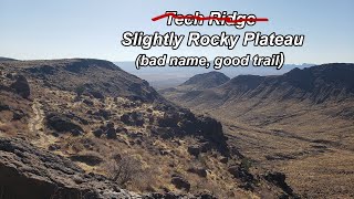
It is the northwestern most piece of trail in the system. This very technical trail has a gentle meadow like entrance.

As you follow the base of the butte, it quickly narrows a becomes exposed. This exposure treats you with a couple rock stalls, followed by two tight switchbacks half a mile into the trail. At this point, Tech Ridge widens into a gentle climb. There is a short loop at the end with a great view across the desert floor.

Access Info

This trail can be accessed from Monolith Gardens using the Foothills Rim Trail connector.

Trail Supporters

  • BLM
    BLM
    Land Manager

Local Trail Association

Traditionally Indigenous Territory

Recent Activity on Trail

Past Week
  • 0 rides
  •  
6 Months
  • 0 rides
  •  
All
  • 24 rides
  • Last: Jun 28, 2026
c1c2c3c4
January
February
March
April
May
June
July
August
September
October
November
December
update trails status or condition

Tech Ridge Trail Reports

statusdatedescription
Feb 6, 2025 @ 12:00am
Feb 6, 2025
Clear trail, no overgrown veg
Sep 18, 2017 @ 11:16am
Sep 18, 2017
lots of over grown cacti
more »
Status:
on Feb 6, 2025
Dry
Avg: 4.19 (4 votes)
Your vote: 0

view (172)
close
      Directions to tech-ridge trailhead (35.198770, -114.116530)

      Photos

      6 more »
      mtb
      43 |
      Feb 5, 2025 @ 11:59pm
      Feb 5, 2025
      mtb
      39 |
      Feb 5, 2025 @ 11:59pm
      Feb 5, 2025
      mtb
      50 |
      Feb 5, 2025 @ 11:59pm
      Feb 5, 2025
      mtb
      42 |
      Feb 5, 2025 @ 11:59pm
      Feb 5, 2025

      Videos

      1 more »
      Monolith Gardens - Tech Ridge - Top Loop +...
      mtb
      8:35 | 79 | Feb 22, 2025 , Kingman
      4.5 ★★★★★
      4 Ratings
      5 ★ 50%
      4 ★ 50%
      3 ★
      2 ★
      1 ★

      4 Reviews & Comments

      Ampfrog Ampfrog
      Fun trail (especially on the way down) with great views.

      Was disappointed that it was not actually a tech climb: one smooth rock ramp near the start (easy up and down), one rock garden at the first switchback (hard up - might have to HAB 5 ft, easy down). Rest is generally smooth as silk compared to the rock-filled Foothills Rim trail, just occasional minor rocks to roll over now and again. Grade is generally fairly low, no black diamond steep sections. Overall felt like a blue trail.

      The slickrock playground more than made up for the lack of tech here Smile
      Zander9YK0JF
      Great trail. Highly recommended but getting to it is not much fun via the Foothills Rim trail. Still worth doing at least once. Maybe accessing it via Red Trail and Basalt connectors would be better? Didn't try that.
      robertellisw robertellisw
      Black because exposure. Easy trail. Very fun.

      We hope you've been enjoying Trailforks!

      Create a FREE account to view all trail reviews and much more.

      • By schillingsworthTF Pro TRAILFORKS HTA & contributors
      • #44862 - 1,623 views

      Frequently Asked Questions

      ▼ Where is Tech Ridge located?
      Tech Ridge is located in Monolith Gardens, Kingman, Arizona, United States. It is part of the Monolith Gardens trail network. The trailhead is located at coordinates 35.19877, -114.11653.
      ▼ How hard is Tech Ridge?
      Tech Ridge is rated as Blue difficulty. The physical rating is Moderate. The average grade is 2.5%. The climb difficulty is rated Blue.
      ▼ What is the elevation gain for Tech Ridge?
      Tech Ridge has 151 ft of elevation gain. The trail has 44 ft of elevation descent. The elevation ranges from 3,842 ft to 3,970 ft.
      ▼ Is Tech Ridge a point to point trail?
      Tech Ridge is not a point to point trail. The direction is Both Directions. The trail type is singletrack.
      ▼ How long is Tech Ridge?
      Tech Ridge is 4,259 ft long. The trail type is singletrack.
      ▼ Are dogs allowed on Tech Ridge?
      Yes, dogs are allowed on Tech Ridge. Please keep dogs on a leash where required and clean up after them.
      ▼ When is the best time of year to ride Tech Ridge?
      Based on activity log data, the most popular months to ride Tech Ridge are:
      • February (3 activities)
      • April (3 activities)
      • November (2 activities)
      Check the reports page for current trail conditions.
      ▼ How do I access Tech Ridge? Where is the closest parking trailhead?
      The closest parking and trailhead locations to Tech Ridge are: View all parking locations in the area.
      ▼ How long does it take to ride Tech Ridge?
      Based on recorded activities, it takes an average of 12 minutes to ride Tech Ridge. The trail is 4,259 ft long. Actual times will vary based on fitness level, conditions, and pace. View recent activity logs for more details.
      ▼ How busy is Tech Ridge?
      Tech Ridge is a moderately popular trail. There have been 101 recorded activities on this trail. The trail has received 172 check-ins. View recent activity on this trail.

      Hit the Trail

      Open in App

      Get this trail on your phone instantly.

      open trail in app

      Download Trail

      Save to wishlist, Garmin & download.
      save the trail

      Find Related Routes

      Find routes and users activities that include this trail.
      find routes for this trail

      You must enter a description before submitting.