The 'stache Details
-
Activities
- Mountain Bike
- E-Bike
-
Riding AreaSouth Rutherford
Pemberton, British Columbia -
AKAShaft
-
Difficulty Rating
-
Voted DifficultyBlack Diamond (2 votes)
-
Trail TypeSingletrack
-
Bike TypeDH, AM
-
DirectionDownhill OnlyPopular direction shown
-
Dogs AllowedYes
-
eBike AllowedYes up to Class 1
-
TTFs on TrailBerm, Drop, Rock Face
-
Global Ranking#8611 in Mountain Biking
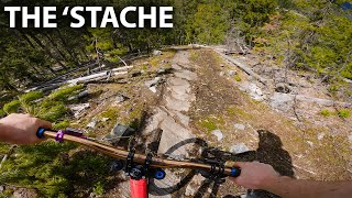
Cut and rake style trail that rides relatively smooth in its natural state. It follows a ridge with some granite features and faces down to nearly the bottom of the FSR. A rather significant, but not too hard, granite sting in the tail awaits you near the bottom. Let the bike run and have a good time.
Access Info
Climb the South Rutherford Cr FSR to the 3km sign. Turn left into the woods, across the creek (might be dry in the summer) and up the short, punchy hill to the start of Lower PhD. Turn left at top of hill and head 20m or so to the start of the trail on your right
This trail is unsanctioned.
Traditionally Indigenous Territory
More Stats for The 'stache mountain bike trail trail
-
Altitude change-736 ft
-
Altitude min1,323 ft
-
Altitude max2,058 ft
-
Altitude start2,058 ft
-
Altitude end1,323 ft
-
Grade-21.853%
-
Grade max-36.745%
-
Grade min5.215%
-
Distance climb63 ft
-
Distance down3,274 ft
-
Distance flat30 ft
-
Avg time00:11:40
-
Avg reverse time00:29:33
- view trail stats
-
Layers w
- Map Content
- More Layers
- Pro
- Pro
- Pro
- Pro
- Pro
- Pro
- Pro
- Pro
-
Upgrade to

- Unknown
- Snow Groomed
- Snow Packed
- Snow Covered
- Snow Cover Partial
- Freeze/thaw Cycle
- Icy
- Prevalent Mud
- Wet
- Variable
- Ideal
- Dry
- Very Dry
The colour categories are based on what percentage of riders are riding a trail in its intended direction.
- > 96%
- > 90%
- > 80%
- > 70%
- > 50%
- < 50%
- bi-directional trail
- no data
- < 2 days
- < 1 week
- < 2 weeks
- < 1 month
- < 6 months
- > 6 months
- Downhill Only
- Downhill Primary
- Both Directions
- Uphill Primary
- Uphill Only
- One Direction
- Description
- Photos
- Description & Photos
- Videos
- most popular
- popular
- less popular
- not popular

- mountain biking recent
- mountain biking (>6 month)
- hiking (1 year)
- moto (1 year)
- Downhill Ski
- Backcountry Ski
- Nordic Ski
- Snowmobile
Save the current map location and zoom level as your default home location whenever this page is loaded.
SaveThe 'stache Trail Reports
Recent Ridelog Activity on Trail
- 11 rides
- 6 miles avg distance
- 45 rides
- 7 miles avg distance
- 892 rides
- Last: May 19, 2024
Photos
15 Reviews & Comments
We hope you've been enjoying Trailforks!
Create a FREE account to view trail comments and much more.
Videos


Nearby Trails
- Whiskey In The Jar 138 ft
- Access Road 3,438 ft
- Bailout Connector 4,003 ft
- Phd Middle 4,547 ft
- South Rutherford Creek Climb 1 mile
- #103776 - 4,061 views
- follow/subscribe
- login to download gpx or kml files.
You must enter a description before submitting.