close
-
Layers w
- Weather Layers
- Pro
- Pro
- Pro
- Pro
- Pro
- Pro
- More Layers
- Pro
- Pro
- Pro
- Pro
-
Upgrade to

3D
Trail Conditions
- Unknown
- Snow Groomed
- Snow Packed
- Snow Covered
- Snow Cover Partial
- Freeze/thaw Cycle
- Icy
- Prevalent Mud
- Wet
- Variable
- Ideal
- Dry
- Very Dry
Trail Flow (Ridden Direction)
Trailforks scans users ridelogs to determine the most popular direction each trail is ridden. A good flowing trail network will have most trails flowing in a single direction according to their intension.
The colour categories are based on what percentage of riders are riding a trail in its intended direction.
The colour categories are based on what percentage of riders are riding a trail in its intended direction.
- > 96%
- > 90%
- > 80%
- > 70%
- > 50%
- < 50%
- bi-directional trail
- no data
Trail Last Ridden
Trailforks scans ridelogs to determine the last time a trail was ridden.
- < 2 days
- < 1 week
- < 2 weeks
- < 1 month
- < 6 months
- > 6 months
Trail Ridden Direction
The intended direction a trail should be ridden.
- Downhill Only
- Downhill Primary
- Both Directions
- Uphill Primary
- Uphill Only
- One Direction
Contribute Details
Colors indicate trail is missing specified detail.
- Description
- Photos
- Description & Photos
- Videos
Trail Popularity ?
Trailforks scans ridelogs to determine which trails are ridden the most in the last 9 months.
Trails are compared with nearby trails in the same city region with a possible 25 colour shades.
Think of this as a heatmap, more rides = more kinetic energy = warmer colors.
- most popular
- popular
- less popular
- not popular
ATV/ORV/OHV Filter
Max Vehicle Width
inches
US Cell Coverage
Legend

Radar Time
Activity Recordings
Trailforks uses anonymized public activity data.
?
Activity Recordings
Trailforks uses anonymized public activity data.
?
Personal Heatmap
▶
Activity Types
all
/
none
▶
Options
2
Date range
month
–
Winter Trails
Warning
A routing network for winter maps does not exist. Selecting trails using the winter trails layer has been disabled.
Missing Trails
Most Popular
Least Popular
Trails are colored based on popularity. The more popular a trail is, the more red. Less popular trails trend towards green.
Jump Magnitude Heatmap
Heatmap of where riders jump on trails. Zoom in to see individual jumps, click circles to view jump details.
BC Backroad Status
![map legend]()
Service Road Atlas is a free to use, community-driven service for viewing and creating reports on the numerous back-country service roads around B.C. and Alberta.

Slope Aspect
Direction the slope faces
Trails Deemphasized
Trails are shown in grey.
Only show trails with no bike usage.
Suggested Layers
Based on selected activity type
Save the current map location and zoom level as your default home location whenever this page is loaded.
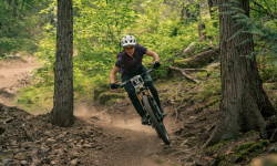
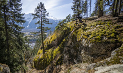
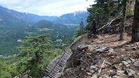
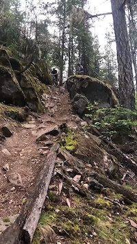
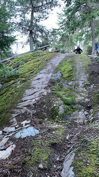
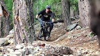
SavePemberton has a mix of world-class biking, hiking, horse back riding and dirt bike trails. Most trails are accessible directly from the Village of Pemberton.
Pemberton and offers a good variety of cross country, downhill and uphill terrain. Most trails are for the intermediate level and up.
Did you know?
You are recreating on the unceded Traditional Territory of the Líl̓wat Nation.
Building unsanctioned trails is prohibited and can potentially damage significant Líl̓wat archaeological, cultural, and harvesting sites that folks may not know about.
Thank you for respecting and protecting this land.
Let’s educate, learn, nek̓wk̓wezúsem - work together
Please continue to enjoy the existing trails
Kúkwstumckacw -Kook-sh-toom-kaw -Thank You!
Links
- https://www.pembertontrails.com/
- https://www.porcabikes.com/
- https://www.pdba.ca/
- https://pembertonvalleyhorses.com/
Files
- 2025_Kiosk_Map_FINAL.pdf (39.62 MB)
- PhDmap_2018_02.pdf (2.59 MB)
Activities Click to view
- Mountain Bike
189 trails
- E-Bike
282 trails
- Gravel Bike
1 trails
- Adaptive Bike
0 trails
- Winter Fat Bike
0 trails
- Horse
42 trails
- Hike
261 trails
- Trail Running
255 trails
- Dirtbike/Moto
48 trails
- Observed Trials
18 trails
- ATV/ORV/OHV
5 trails
- Snowshoe
72 trails
- Backcountry Ski
142 trails
- Nordic Ski
4 trails
Region Details
- 15
- 32
- 68
- 45
- 22
- 3
Region Status
Open as of 1 dayLocal Trail Association
Stats
- Avg Trail Rating
- Trails (view details)
- 373
- Trails Mountain Bike
- 189
- Trails E-Bike
- 282
- Trails Gravel Bike
- 1
- Trails Horse
- 42
- Trails Hike
- 261
- Trails Trail Running
- 255
- Trails Dirtbike/Moto
- 48
- Trails Observed Trials
- 18
- Trails ATV/ORV/OHV
- 5
- Trails Snowmobile
- 2
- Trails Snowshoe
- 72
- Trails Backcountry Ski
- 142
- Trails Nordic Ski
- 4
- Total Distance
- 456 miles
- Total Descent
- 217,237 ft
- Total Vertical
- 8,388 ft
- Highest Trailhead
- 9,055 ft
- Reports
- 5,825
- Photos
- 2,359
- Ridden Counter
- 154,447
Articles
Details Announced for 2026 Spud Crusher Women’s Enduro
Feb 10, 2026 from pinkbike.com
The Spud Crusher Women’s Enduro will be returning to the trails on May 9th, 2026.
Video: Yoann Barelli, Remy Metailler & Steve Vanderhoek Ride An Insane Line in Pemberton, BC
Apr 9, 2021 from pinkbike.com
An alternate line that definitely isn't for the faint of heart.

Video: The Sounds of Hardtail Shredding in Pemberton
Jul 7, 2020 from pinkbike.com
It's all about the sound of the bike and rider tearing down the trail.

Field Test: 13 Bikes VS The Impossible Climb
Dec 26, 2019 from pinkbike.com
Thirteen bikes compete for honors up a tricky climb littered with roots, wet rocks, tight corners... And banana peels?
Sub Regions
-
Duffey / Joffre / Cayoosh
- 1
-
Mackenzie
- 4
- 17
- 15
- 9
- 2
-
Mosquito Lake
- 9
- 39
- 17
- 7
- 1
-
One Mile Lake
- 11
- 11
- 9
- 2
-
South Rutherford
- 2
- 2
- 2
- 3
-
Upper Pemberton and Signal Hill
- 6
- 2
-
Valley
- 3
- 3
Popular Pemberton Mountain Biking Trails
• 100 ★ 4.5 • 4,793 ft • 473 ft • 3,064 •
The best climbing trail you will ever ride. Drains well so easy to ride in the wet or after rain without causing trail damage. Reworked this past fall (2017) to make it easier for all to ride, much smoother now.
• 95 ★ 4.1 • 3 miles • 1,048 ft • 2,988 •
Great, challenging, but fair climb with lots of switchbacks. This is an amazing hand built climbing trail that needs to be ridden if you are riding in Pemberton. So much better than ridding an FSR
• 90 ★ 4.3 • 1 mile • 60 ft • 2,560 •
A Pemberton classic and must-ride. It is a relatively steep descent with a couple uphill punches. There are rocky bits and loose steep chutes with a go-around detour. All-mountain bikes are plenty capable for this trail. Also the views...
• 100 ★ 4.0 • 4,012 ft • 226 ft • 2,477 •
Long upper portion of WACo after the switch back. An older double track that rides more like a single track now. Easier and less direct than climb to get to after riding
• 100 ★ 4.1 • 3,002 ft • 10 ft • 2,388 •
is a fun intermediate trail that delivers lots of personality through a beautiful bit of forest. the trail will deliver a bit of flow, jumps, chunk and speed all with a smile on your face. Either blast through the junction near the...
• 100 ★ 3.9 • 1,703 ft • 85 ft • 2,376 •
Mellow climb from the top of to the gaining access to the trails
• 100 ★ 4.5 • 745 ft • 14 ft • 2,262 •
Fun exit off Cross Town to parking lot through several small berms with a drop, jump, step up and small rock drop...lots of fun!
Pemberton Mountain Bike Routes
★ 4.5 • 12 miles • 3,157 ft • 18 • Loop •
This is a fun loop and a longer ride for Advanced riders, featuring some larger features and climbs. Begin...
★ 4.0 • 6 miles • 1,129 ft • 9 • Loop •
Lap one of the 2016 Lumpy's Trifecta. A good 1-2 hour sampler of 1 Mile Trails. Note that you can follow...
4 miles • 1,074 ft • 4 •
This week’s Fiver takes on a fast and flowy lap in the Mackenzie zone. Course: Bob Gnarly to Lower...
5 miles • 1,130 ft • 4 •
This week’s Fiver takes on a fast and flowy lap in the Mackenzie zone. Course: Bob Gnarly to Lower...
4 miles • 940 ft • 2 •
PORCA Fiver #3 April 29th This week's Fiver is brought to you by Arbutus Routes, Pemberton Brewing and...
3 miles • 983 ft • 1 •
This week’s Fiver heads to the Mackenzie zone for the fall fiver return. Course: From to Sign In Time:...
Photos of Pemberton Mountain Bike
Videos of Pemberton Mountain Bike
trail: The 306
0:09 |
75 |
Jul 11, 2025

trail: The 'stache
4:14 |
35 |
Nov 25, 2023
trail: Shasta
2:15 |
174 |
Aug 19, 2021
trail: Jack the Ripper
0:07 |
773 |
Jun 22, 2021
trail: Live Like Lisa
0:12 |
292 |
May 22, 2021
trail: PHD Middle
0:11 |
217 |
Nov 14, 2020
trail: Cop Killer
0:19 |
268 |
Oct 8, 2020
trail: Shasta
2:35 |
167 |
Jul 25, 2020
Current Trail Warnings
| status | trail | date | condition | user | info |
|---|---|---|---|---|---|
| Cream Puff | Jun 16, 2026 @ 10:39am (America/Vancouver) Jun 16, 2026 | Unknown | AriLar PVTA | Due to the insurance requirements... | |
| Whiskey In The Jar | Jun 14, 2026 @ 7:50pm (America/Vancouver) Jun 14, 2026 | Dry | ebwitwicki | Closed for Maintenance |
Recent Trail Reports
| status | trail | date | condition | info | user |
|---|---|---|---|---|---|
| Waco Connector | Jul 10, 2026 @ 9:56am (America/Vancouver) 1 day | Ideal | Shawnsrides | ||
| Shama | Jul 10, 2026 @ 9:56am (America/Vancouver) 1 day | Ideal | Shawnsrides | ||
| Waco Connector | Jul 10, 2026 @ 9:56am (America/Vancouver) 1 day | Ideal | Shawnsrides | ||
| Upper Mackenzie Cruise | Jul 10, 2026 @ 9:56am (America/Vancouver) 1 day | Dry | Shawnsrides | ||
| Overnight Old Line (Hospital Chute) | Jul 10, 2026 @ 9:56am (America/Vancouver) 1 day | Very Dry | Shawnsrides | ||
| Overnight Sensation | Jul 10, 2026 @ 9:56am (America/Vancouver) 1 day | Dry | Shawnsrides | ||
| Gravitrout | Jul 10, 2026 @ 9:56am (America/Vancouver) 1 day | Very Dry | Shawnsrides | ||
| Middle Earth | Jul 10, 2026 @ 9:56am (America/Vancouver) 1 day | Ideal | Shawnsrides | ||
| MacKenzie FSR Connector | Jul 10, 2026 @ 9:56am (America/Vancouver) 1 day | Ideal | Shawnsrides | ||
| Nimby | Jul 10, 2026 @ 9:56am (America/Vancouver) 1 day | Ideal | Shawnsrides |
Activity Feed
| username | action | type | title | date |
|---|---|---|---|---|
| Nilist | wishlist | route | activity #98903488 | Jul 10, 2026 @ 10:12pm 16 hours |
| Shawnsrides | add | report | activity #98883976 and 9 more | Jul 10, 2026 @ 3:03pm 23 hours |
| caspiankai | wishlist | trail | activity #98764367 | Jul 8, 2026 @ 10:26pm 3 days |
| JSnFdzlP | wishlist | region | activity #98763597 | Jul 8, 2026 @ 9:56pm 3 days |
| Katelinroth | ridden | trail | activity #98760806 | Jul 8, 2026 @ 8:26pm 3 days |
Recent Comments
| username | type | title | comment | date |
|---|---|---|---|---|
| trail | tree down see photo for location, 27 1/2 in... | Jul 5, 2026 @ 8:15am Jul 5, 2026 | ||
| trail | One of those trail that is definitely gets... | Jul 4, 2026 @ 12:53pm Jul 4, 2026 | ||
| trail | Very good ! They're not messing around in... | Jul 4, 2026 @ 12:49pm Jul 4, 2026 | ||
| trail | uuuuuh mama she’s a spicy one… i mean the... | Jun 28, 2026 @ 8:18pm Jun 28, 2026 | ||
| trail | Great little section - rode northbound on... | Jun 22, 2026 @ 12:01am Jun 22, 2026 |
Local Badges
-

Completionist0 awarded -

Big Ride 30k2,202 awarded -

Epic Ride 50k844 awarded -

10 Expert Trails194 awarded -

Top 10 Trails109 awarded -
Completionist5 awarded
Bike & Skill Parks
| name | type | city | rating |
|---|---|---|---|
| Pemberton Motocross Park | skill park | Pemberton | |
| Pemberton Bike Skills Park | skill park | Pemberton | |
| Pemberton BMX Track | skill park | Pemberton |
Local Products
Activity Type Stats
| activitytype | trails | distance | descent | descent distance | total vertical | rating | global rank | state rank | photos | reports | routes | ridelogs |
|---|---|---|---|---|---|---|---|---|---|---|---|---|
| Mountain Bike | 189 | 147 miles | 56,909 ft | 73 miles | 6,463 ft | #112 | #13 | 2,099 | 5,755 | 94 | 64,842 | |
| E-Bike | 282 | 280 miles | 179,039 ft | 159 miles | 8,389 ft | #114 | #19 | 14 | 5,128 | 4 | 3,046 | |
| Gravel Bike | 1 | #149 | #73 | 12 | 57 | |||||||
| Horse | 42 | 56 miles | 3,553 ft | 17 miles | 4,469 ft | #91 | #8 | 58 | 1,580 | 18 | ||
| Hike | 261 | 285 miles | 73,323 ft | 108 miles | 8,005 ft | #224 | #18 | 148 | 5,693 | 2 | 6,743 | |
| Trail Running | 255 | 273 miles | 71,437 ft | 105 miles | 7,717 ft | #242 | #22 | 5 | 5,720 | 7 | 5,659 | |
| Dirtbike/Moto | 48 | 28 miles | 2,680 ft | 7 miles | 6,437 ft | #37 | #12 | 25 | 1,964 | 366 | ||
| Observed Trials | 18 | 17 miles | 3,399 ft | 6 miles | 3,737 ft | #25 | #9 | 1 | 482 | 30 | ||
| ATV/ORV/OHV | 5 | 22 miles | 1,857 ft | 5 miles | 6,437 ft | #89 | #13 | 1 | 1,931 | 29 | ||
| Snowmobile | 2 | 15 miles | 689 ft | 3 miles | 4,403 ft | 6 | 20 | |||||
| Snowshoe | 72 | 130 miles | 14,701 ft | 33 miles | 7,549 ft | #46 | #9 | 440 | 95 | |||
| Backcountry Ski | 142 | 247 miles | 141,001 ft | 113 miles | 8,330 ft | #7 | #2 | 4 | 388 | 3,417 | ||
| Nordic Ski | 4 | 10 miles | 420 ft | 3 miles | 1,050 ft | #235 | #19 | 16 | 394 |
Frequently Asked Questions About Pemberton
▼
What are the best places to ride in Pemberton?
Pemberton has 14 areas to explore for mountain biking. The top rated areas are:
▼
What are the highest rated mountain biking trails in Pemberton?
The highest rated mountain biking trails in Pemberton are:
- The 'stache (4.7/5)
- Max Pains (4.6/5)
- PHD Middle (4.6/5)
- The 306 (4.6/5)
- Cop Killer (4.6/5)
▼
What is the best time of the year to ride in Pemberton?
Based on ride log data, the most popular months to ride in Pemberton are:
- July (1,009 activities)
- May (963 activities)
- April (930 activities)
▼
Where can I park to ride in Pemberton?
There are 23 parking locations listed in Pemberton. The most popular parking spots are: View all parking and trailhead locations on the map to plan your visit.
Activities
- Pemberton Mountain Biking Trails
- Pemberton E-Biking Trails
- Pemberton Horseback Trails
- Pemberton Hiking Trails
- Pemberton Trail Running Trails
- Pemberton Dirtbiking Trails
- Pemberton Observed Trials Trails
- Pemberton ATVing/Offroading Trails
- Pemberton Snowshoeing Trails
- Pemberton Backcountry Skiing Trails
Trails
Points of Interest
- By canadaka
 Trailforks & contributors
 - Admins: PORCA, PVTA, HowlerContractingLimited, Pembree, 99, snowdan
- #3015 - 136,598 views
- pemberton activity log | embed map of Pemberton mountain bike trails | pemberton mountain biking points of interest polygons
Downloading of trail gps tracks in kml & gpx formats is enabled for Pemberton.
You must login to download files.