The Gully Details
-
Activities
- Mountain Bike
- E-Bike
-
Riding AreaCannock Chase
Rugeley -
Difficulty Rating
-
Trail TypeSingletrack
-
Bike TypeAM, XC
-
DirectionUphill OnlyPopular direction shown
-
Climb DifficultyBlue
-
Physical RatingEasy
-
Dogs AllowedYes
-
eBike AllowedYes up to Class 1
-
Ride in RainYes
-
Global Ranking
-
Local Popularity75 in Mountain Biking [+]
- 75 in E-Biking
-
Land Owner
No description for The Gully trail has been added yet!
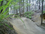
The Gully is a 419 m popular red singletrack trail located near Rugeley. This mountain bike primary trail can be used uphill only and has a easy overall physical rating with a 32 m blue climb. On average it takes 3 minutes to complete this trail.
Local Trail Association
-

-
Please consider joining or donating to the local trail association to supportdonate to earn trail karma!
trail development & maintenance.
More Stats for The Gully mountain bike trail trail
-
Altitude change73 ft
-
Altitude min592 ft
-
Altitude max689 ft
-
Altitude start592 ft
-
Altitude end666 ft
-
Grade5.339%
-
Grade max-21.177%
-
Grade min19.205%
-
Distance climb1,053 ft
-
Distance down256 ft
-
Distance flat67 ft
-
Avg time00:03:25
-
Avg reverse time00:02:17
- view trail stats
-
Layers w
- Map Content
- More Layers
- Pro
- Pro
- Pro
- Pro
- Pro
- Pro
- Pro
- Pro
-
Upgrade to

- Unknown
- Snow Groomed
- Snow Packed
- Snow Covered
- Snow Cover Partial
- Freeze/thaw Cycle
- Icy
- Prevalent Mud
- Wet
- Variable
- Ideal
- Dry
- Very Dry
The colour categories are based on what percentage of riders are riding a trail in its intended direction.
- > 96%
- > 90%
- > 80%
- > 70%
- > 50%
- < 50%
- bi-directional trail
- no data
- < 2 days
- < 1 week
- < 2 weeks
- < 1 month
- < 6 months
- > 6 months
- Downhill Only
- Downhill Primary
- Both Directions
- Uphill Primary
- Uphill Only
- One Direction
- Description
- Photos
- Description & Photos
- Videos
- most popular
- popular
- less popular
- not popular

- mountain biking recent
- mountain biking (>6 month)
- hiking (1 year)
- moto (1 year)
- Downhill Ski
- Backcountry Ski
- Nordic Ski
- Snowmobile
Save the current map location and zoom level as your default home location whenever this page is loaded.
SaveThe Gully Trail Reports
Recent Ridelog Activity on Trail
- 17 rides
- 14 miles avg distance
- 297 rides
- 13 miles avg distance
- 5,479 rides
- Last: May 16, 2024
Photos
Routes with this trail
Reviews / Comments
No reviews yet, be the first to write a review or ask a question.
Use trail reports to comment on trail conditions.
We hope you've been enjoying Trailforks!
Create a FREE account to view trail comments and much more.
Videos


Nearby Trails
- Forest Road 26 ft
- Access Road 125 ft
- Rainbow Valley 971 ft
- Over The Rainbow 1,017 ft
- Forest Road 1,654 ft
- By brenthillier
 NSMBA TRAILFORKS & contributors
 - #120014 - 915 views
- follow/subscribe
- login to download gpx or kml files.
You must enter a description before submitting.