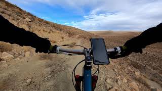
more stats
3.9 miles
Distance
170 ft
Climb
-341 ft
Descent
00:37:44
Avg time
-172 ft
Altitude change
3,081 ft
Altitude min
3,254 ft
Altitude max
3,253 ft
Altitude start
3,081 ft
Altitude end
-0.8%
Grade
-17.5%
Grade max
16.8%
Grade min
1 mile
Distance climb
2 miles
Distance down
4,367 ft
Distance flat
00:37:44
Avg time

The Stash Details

  • Activities
    • Mountain Bike
    • Hike
    • Trail Running
  • Riding Area
    Red Rock - Bear’s Best
    Las Vegas, Nevada
  • Difficulty Rating
  • Voted Difficulty
    Blue (1 vote)
  • Local Popularity
    50 in Mountain Biking heatmap [+]
    • 5 in Trail Running
    • 5 in Hiking
  • Global Ranking
    #103511 in Mountain Biking [+]
    • #354911 in Trail Running
    • #342736 in Hiking
  • State Ranking
    #570 in Mountain Biking · Nevada [+]
    • #1,530 in Trail Running
    • #1,504 in Hiking
  • Trail Type
    Singletrack
  • Bike Type
    AM, XC
  • Climb Difficulty
    Green
  • Physical Rating
    Easy
  • Season
    Year Round
  • Dogs Allowed
    Yes
  • eBike Allowed

The Stash is a mellow meandering trail between what's known as The Ridge trail system and Cottonwood. It can be ridden both directions and can be connected to The Ridge via dirt road.

Tags

Trail Supporters

  • BLM
    BLM
    Land Manager

Local Trail Association

Recent Activity on Trail

Past Week
  • 0 rides
  •  
6 Months
  • 1 rides
  • 5 miles avg distance
All
  • 127 rides
  • Last: Jun 18, 2026
c1c2c3c4
January
February
March
April
May
June
July
August
September
October
November
December
update trails status or condition

The Stash Trail Reports

statusdatedescription
Apr 9, 2024 @ 11:15am
Apr 9, 2024
Oct 24, 2023 @ 9:53am
Oct 24, 2023
Trail can be accessed by parking west of the natural gas piping system which is just west of the new flood retention system being built. Some...
Aug 24, 2022 @ 9:52pm
Aug 24, 2022
The trail head to access this via union pacific is closed. They're building a flood retention system. Parking access is blocked.
Aug 14, 2021 @ 5:31am
Aug 14, 2021
Several large ruts after the rains
Mar 14, 2021 @ 9:35am
Mar 14, 2021
more »
Status:
on Apr 9, 2024
Dry
Avg: 4.07 (8 votes)
Your vote: 0

view (535)
close
      Directions to the-stash trailhead (36.062390, -115.345280)

      Photos

      No photos have been added for The Stash yet, add a photo.

      Videos

      1 more »
      01/23/2021  - The Stash @ Southwest Ridge
      mtb
      13:10 | 641 | Feb 3, 2022 , Las Vegas

      Routes with this trail

      more »
      ★ 4.0 • 13 miles • 934 ft • 27 • Loop •
      Riding from Blue Diamond road (cougar rd pull off), into the stash network, and then up above Bears Best...
      41 miles • 3,227 ft • 58 •
      Bears best to Late Nite. 40 miles. Make sure you bring enough water and food.
      ★ 1.0 • 41 miles • 3,227 ft • 58 •
      Bears best to Late Nite. 40 miles. Make sure you bring enough water and food.
      4.2 ★★★★★
      8 Ratings
      5 ★ 63%
      4 ★
      3 ★ 25%
      2 ★ 13%
      1 ★

      2 Reviews & Comments

      kpinwalla2
      Cannot be accessed from the south via old railroad grade due to no trespassing signs.
      Wlippia
      In very bad condition after recent rains

      We hope you've been enjoying Trailforks!

      Create a FREE account to view all trail reviews and much more.

      • By sccurranTF Pro & contributors
      • #30277 - 3,978 views

      Frequently Asked Questions

      ▼ Where is The Stash located?
      The Stash is located in Red Rock - Bear’s Best, Las Vegas, Nevada, United States. It is part of the Red Rock - Bear’s Best trail network. The trailhead is located at coordinates 36.06239, -115.34528.
      ▼ How hard is The Stash?
      The Stash is rated as Green difficulty. The physical rating is Easy. The average grade is 0.8%. The climb difficulty is rated Green.
      ▼ What is the elevation gain for The Stash?
      The Stash has 170 ft of elevation gain. The trail has 341 ft of elevation descent. The elevation ranges from 3,081 ft to 3,254 ft.
      ▼ How long is The Stash?
      The Stash is 3.9 miles long. The trail type is singletrack.
      ▼ Are dogs allowed on The Stash?
      Yes, dogs are allowed on The Stash. Please keep dogs on a leash where required and clean up after them.
      ▼ When is the best time of year to ride The Stash?
      Based on activity log data, the most popular months to ride The Stash are:
      • October (5 activities)
      • January (3 activities)
      • April (3 activities)
      Check the reports page for current trail conditions.
      ▼ How do I access The Stash? Where is the closest parking trailhead?
      The closest parking and trailhead locations to The Stash are: View all parking locations in the area.
      ▼ How long does it take to ride The Stash?
      Based on recorded activities, it takes an average of 38 minutes to ride The Stash. The trail is 3.9 miles long. Actual times will vary based on fitness level, conditions, and pace. View recent activity logs for more details.
      ▼ How busy is The Stash?
      The Stash is a moderately popular trail. There have been 477 recorded activities on this trail. The trail has received 535 check-ins. View recent activity on this trail.

      Hit the Trail

      Open in App

      Get this trail on your phone instantly.

      open trail in app

      Download Trail

      Save to wishlist, Garmin & download.
      save the trail

      Find Related Routes

      Find routes and users activities that include this trail.
      find routes for this trail

      You must enter a description before submitting.