3,593 ft
Distance
3 ft
Climb
-305 ft
Descent
00:07:55
Avg time
Thornstar Details
-
Activities
- Mountain Bike
- Hike
- Trail Running
-
Riding AreaThornhill
Maple Ridge, British Columbia -
Difficulty Rating
-
Voted DifficultyBlack Diamond (1 vote)
-
Trail TypeSingletrack
-
Bike TypeAM
-
DirectionDownhill OnlyPopular direction shown
-
Physical RatingModerate
-
Dogs AllowedYes
-
eBike Allowed
-
TTFs on TrailBerm, Bridge, Jump, Gap Jump, Log Ride
-
Global Ranking
-
Local Popularity100 in Mountain Biking [+]
- 90 in Trail Running
- 45 in Hiking
-
Land ManagerCity of Maple Ridge
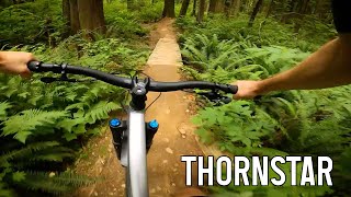
The trail itself is a blue, but there is many gap jumps of various sizes making the trail a black diamond if you're hitting the jumps. Ride arounds for all features.
A horse trail crosses Thornstar. Please make noise at the crossing and yield to horses.
Local Trail Association
-
Please consider joining or donating to the local trail association to supportdonate to earn trail karma!
trail development & maintenance.
Traditionally Indigenous Territory
More Stats for Thornstar mountain bike trail trail
-
Altitude change-304 ft
-
Altitude min771 ft
-
Altitude max1,080 ft
-
Altitude start1,075 ft
-
Altitude end771 ft
-
Grade-8.5%
-
Grade max-28%
-
Grade min3.2%
-
Distance climb167 ft
-
Distance down3,209 ft
-
Distance flat200 ft
-
Avg time00:07:55
-
Avg reverse time00:19:58
- view trail stats
close
Trail Conditions
- Unknown
- Snow Groomed
- Snow Packed
- Snow Covered
- Snow Cover Inadequate
- Freeze/thaw Cycle
- Icy
- Prevalent Mud
- Wet
- Variable
- Ideal
- Dry
- Very Dry
Trail Flow (Ridden Direction)
Trailforks scans users ridelogs to determine the most popular direction each trail is ridden. A good flowing trail network will have most trails flowing in a single direction according to their intension.
The colour categories are based on what percentage of riders are riding a trail in its intended direction.
- > 96%
- > 90%
- > 80%
- > 70%
- > 50%
- < 50%
- bi-directional trail
- no data
Trail Last Ridden
Trailforks scans ridelogs to determine the last time a trail was ridden.
- < 2 days
- < 1 week
- < 2 weeks
- < 1 month
- < 6 months
- > 6 months
Trail Ridden Direction
The intended direction a trail should be ridden.
- Downhill Only
- Downhill Primary
- Both Directions
- Uphill Primary
- Uphill Only
- One Direction
Contribute Details
Colors indicate trail is missing specified detail.
- Description
- Photos
- Description & Photos
- Videos
Trail Popularity ?
Trailforks scans ridelogs to determine which trails are ridden the most in the last 9 months.
Trails are compared with nearby trails in the same city region with a possible 25 colour shades.
Think of this as a heatmap, more rides = more kinetic energy = warmer colors.
- most popular
- popular
- less popular
- not popular
ATV/ORV/OHV Filter
Max Vehicle Width
inches
Radar Time
x
Activity Recordings
Trailforks users anonymized public ridelogs from the past 6 months.
- mountain biking recent
- mountain biking (>6 month)
- hiking (1 year)
- moto (1 year)
Activity Recordings
Trailforks users anonymized public skilogs from the past 12 months.
- Downhill Ski
- Backcountry Ski
- Nordic Ski
Jump Magnitude Heatmap
Heatmap of where riders jump on trails. Zoom in to see individual jumps, click circles to view jump details.
Trails Deemphasized
Trails are shown in grey.
Only show trails with NO bikes.
Save the current map location and zoom level as your default home location whenever this page is loaded.
Save
Directions to thornstar trailhead
(49.200110, -122.511680)
update trails status or condition
Thornstar Trail Reports
view all reports »
Recent Ridelog Activity on Trail
Past Week
- 43 rides
- 7 miles avg distance
6 Months
- 881 rides
- 7 miles avg distance
All
- 6,458 rides
Photos
more »
Routes with this trail
Trail Products
-
Fraser Valley GuideBook
-
+ 1

Still soft and loamy,
[Reply]

Good trail. Lots of small-medium gap jumps. The trail is a bit soft so in some spots its hard to get all the speed that you need. What it really needs is a lot of riders to pack it down.
There is one section that is poorly thought out. It's about 1/2 way down where some fallen trees are used. Do not jump this straight on. I did and ended up off my bike into a stump.
The access is not obvious. You have to follow gap in the fence between the two antenna compounds. Straight up from the road. Then Follow the fence to your right and you'll see the cool metal Thorn Star sign.
[Reply]
There is one section that is poorly thought out. It's about 1/2 way down where some fallen trees are used. Do not jump this straight on. I did and ended up off my bike into a stump.
The access is not obvious. You have to follow gap in the fence between the two antenna compounds. Straight up from the road. Then Follow the fence to your right and you'll see the cool metal Thorn Star sign.

Going to start fixing that jump mulletator. Rerouting trail slightly from the landing of that jump so it is a straight on . Some hikers have taken it personally about the progression on that side of the hill and have been sabotaging the trail. Rerouting slightly might make them happier. Rode it today and is riding quite well, I understand what you mean about the jump. spent more time building it and now that I am riding it can work out the little kinks.
[Reply]

Very nice trail, but it's still super soft which can make it a chore to ride.
[Reply]


I love this trail. It’s got something for everyone. I did find it difficult to see some or the ride arounds for a couple of the jumps but that’s prob cuz I was going a little quick for a trail I don’t know that well.
[Reply]


Trail crew was just there last weekend buffing everything out. Trail is mint!
Awesome work!
[Reply]
Awesome work!
italianjob777
(Aug 29, 2020 at 9:51)

Lots of updates including a side trail that loops you around. Good condition.
[Reply]


Has the GPS end marker been moved to across the fire road?!? My track time didn't stop until I reached the gate! Can someone fix that, please??
[Reply]
Jamzbund
(Sep 10, 2021 at 22:14)

Mint, optional jump features marked with orange flags. Great time blasting through this trail.
[Reply]
Caedmonkovacs
(Oct 12, 2021 at 22:53)
An amazing trail. It's a black jump trail with a little tech but could easily be a blue if you avoid certain features. Really fun trail and once you ride it a couple of times and get it down, you will be flying down it. Thank you so much to the trail builders.
[Reply]
Videos
more »
Nearby Trails
- Access 0 ft
- O.s.r. 725 ft
- Access Trail 1,043 ft
- Moto Loop 1,155 ft
- Nick's 1,309 ft
- embed Thornstar trail on your website
- By AFM73
FVMBA - NORTH & contributors
- #47136 - 11,379 views
- subscribe
- login to download gpx or kml files.
Open trail in mobile app