more stats
2,656 ft
Distance
128 ft
Climb
-16 ft
Descent
00:05:34
Avg time
112 ft
Altitude change
246 ft
Altitude min
370 ft
Altitude max
257 ft
Altitude start
370 ft
Altitude end
4.226%
Grade
-10.69%
Grade max
10.954%
Grade min
2,185 ft
Distance climb
404 ft
Distance down
00:05:34
Avg time

Trail 25 Details

  • Activities
    • Mountain Bike
    • E-Bike
    • Horse
    • Hike
    • Trail Running
  • Riding Area
    Fort Ord National Monument
    Monterey, California
  • Difficulty Rating
  • Local Popularity
    65 in Mountain Biking [+]
    • 65 in E-Biking
    • 90 in Trail Running
    • 75 in Hiking
    • 5 in Horseback
  • Global Ranking
    #96834 in Mountain Biking [+]
    • #82740 in E-Biking
    • #41525 in Trail Running
    • #65451 in Hiking
    • #4366 in Horseback
  • Trail Type
    Singletrack
  • Direction
    Both Directions
    Popular Direction Shown
  • Climb Difficulty
    Green
  • Physical Rating
    Easy
  • Season
    All year
  • Dogs Allowed
    Yes
  • eBike Allowed
    Yes up to Class 1
  • Land Owner

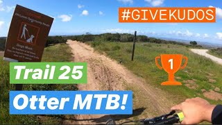
CYCLIST NOTES:It starts out with some nice flowing grade reversals and then goes through a sandy turn and starts up the ridge. There are a couple of steeper sections but the climb is fairly gradual until it flattens out and then connects back to Sandy Ridge Road. Most rides will continue on the road to the right.
NOTE: Riding down this trail can be fun to but watch for uphill traffic.

NATIONAL MONUMENT NOTES:
This BLM managed trail is open from dawn to dusk to cyclists, hikers/joggers, and equestrians. The trail is two-way directional, and cyclists must yield to all other users; hikers/joggers must yield to equestrians. Maximum passing speed limit is less than 5 mph for cyclists for oncoming trail users and when passing those that have slowed/stopped and moved to edge of trail. Please leash your pet.

Access Info

Access via Engineer Rd heading West at both ends.

Trail Supporters
  • BLM
    BLM
    Land Manager
Local Trail Association
Traditionally Indigenous Territory

Recent Activity on Trail

Past Week
  • 2 rides
  • 12 miles average
6 Months
  • 37 rides
  • 36 miles avg distance
All
  • 579 rides
  • Last: Sep 17, 2026
c1c2c3c4
January
February
March
April
May
June
July
August
September
October
November
December
update trails status or condition

Trail 25 Trail Reports

statusdatedescription
Feb 22, 2026 @ 12:57pm (Pacific/Midway)
Feb 22, 2026
Apr 11, 2025 @ 10:35am
Apr 11, 2025
Jan 27, 2024 @ 8:31am
Jan 27, 2024
Jan 6, 2024 @ 12:20am
Jan 6, 2024
There is a deep rut running down a long stretch of this trail. It’s still pretty easy to navigate around it.
May 2, 2023 @ 9:56am
May 2, 2023
more »
Status:
on Feb 22, 2026
Variable
Avg: 3.99 (3 votes)
Your vote: 0

view (4,174)
close
      Directions to trail-25 trailhead (36.629640, -121.695570)

      Photos

      3 more »
      mtb
      411 |
      Oct 27, 2005 @ 5:00pm
      Oct 27, 2005
      mtb
      394 |
      Oct 27, 2005 @ 5:00pm
      Oct 27, 2005
      mtb
      330 |
      Jan 13, 2007 @ 5:18pm
      Jan 13, 2007

      Videos

      2 more »
      Fort Ord MTB: Trail 25 in 4K!! (Strava KOM...
      mtb
      2:31 | 565 | Jun 5, 2019 , Monterey
      Creekside feb 2008
      mtb
      0:16 | 189 | Feb 9, 2008 , Monterey

      Routes with this trail

      15 miles 2,074 ft 531 Loop
      This is a fun tour of the various trails connected to the parking lot, and a great introduction to Fort...
      4.0 15 miles 2,289 ft 263 Loop
      1.5-2 hour loop highlighting some of the best single track and descents in Fort Ord. A local favorite!
      4.0 10 miles 1,168 ft 10 Loop
      Loop route that showcases much of the terrain at Fort Ord.
      4.0
      3 Ratings
      5
      4 100%
      3
      2
      1

      1 Review & Comments

      Geoffire
      Very sandy and lots of hikers. I did it on a gravel bike, would not recommend, would be fun on MTB though

      We hope you've been enjoying Trailforks!

      Create a FREE account to view all trail reviews and much more.

      Frequently Asked Questions

      Where is Trail 25 located?
      Trail 25 is located in Fort Ord National Monument, Monterey, California, United States. It is part of the Fort Ord National Monument trail network. The trailhead is located at coordinates 36.62964, -121.69557.
      How hard is Trail 25?
      Trail 25 is rated as Green difficulty. The physical rating is Easy. The average grade is 4.226%. The climb difficulty is rated Green.
      What is the elevation gain for Trail 25?
      Trail 25 has 128 ft of elevation gain. The trail has 16 ft of elevation descent. The elevation ranges from 246 ft to 370 ft.
      Is Trail 25 a point to point trail?
      Trail 25 is not a point to point trail. The direction is Both Directions. The trail type is singletrack.
      How long is Trail 25?
      Trail 25 is 2,656 ft long. The trail type is singletrack.
      Are dogs allowed on Trail 25?
      Yes, dogs are allowed on Trail 25. Please keep dogs on a leash where required and clean up after them.
      When is the best time of year to ride Trail 25?
      Trail 25 is best visited during: All year.
      How do I access Trail 25? Where is the closest parking trailhead?
      The closest parking and trailhead locations to Trail 25 are: View all parking locations in the area.
      How long does it take to ride Trail 25?
      Based on recorded activities, it takes an average of 6 minutes to ride Trail 25. The trail is 2,656 ft long. Actual times will vary based on fitness level, conditions, and pace. View recent activity logs for more details.
      How busy is Trail 25?
      Trail 25 is a moderately popular trail. There have been 4,133 recorded activities on this trail. The trail has received 4,174 check-ins. View recent activity on this trail.

      Hit the Trail

      Open in App

      Get this trail on your phone instantly.

      open trail in app

      Download Trail

      Save to wishlist, Garmin & download.
      save the trail

      Find Related Routes

      Find routes and users activities that include this trail.
      find routes for this trail

      You must enter a description before submitting.