3,953 ft
Distance
-750 ft
Descent
00:23:27
Avg time

Tranquada Details

  • Activities
    • Mountain Bike
  • Riding Area
  • Ref Number
    SS6
  • Difficulty Rating
  • Trail Type
    Singletrack
  • Bike Type
    DH, AM, XC
  • Direction
    Downhill Only
    Popular direction shown
  • Physical Rating
    Moderate
  • Trail Visibility
    Always easy to follow
  • Dogs Allowed
    Yes
  • eBike Allowed
    Yes up to Class 1
  • TTFs on Trail
    Berm, Drop, Jump, Gap Jump, Rock Garden, Roller Coaster
  • Global Ranking
    #14007 in Mountain Biking
  • Local Popularity
    50 in Mountain Biking
  • Year Opened
    2019
  • Land Owner
    CNSeixal

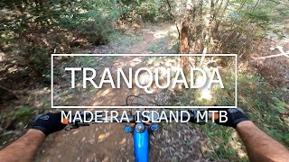
Percurso Especial muito técnico, especialmente se o piso estiver molhado. Muitos rockgardens, raízes e alguns saltos com gap. Traquada é um dos percursos mais antigos que ligava a Ribeira da Janela às zonas altas de floresta e que se mantém mais ou menos na sua forma original, adaptado para a prática do BTT. Na ligação à Eira da Achada, onde podem apreciar uma das mais belas vistas da costa norte da Madeira, podemos observar uma pequena secção do antigo caminho real, as mais antigas vias de comunicação que ligavam toda a ilha.

Access Info

Zona do prado do Fanal

This trail is unsanctioned.

More Stats for Tranquada mountain bike trail trail
  • Altitude change
    -750 ft
  • Altitude min
    1,534 ft
  • Altitude max
    2,283 ft
  • Altitude start
    2,283 ft
  • Altitude end
    1,535 ft
  • Grade
    -19%
  • Grade max
    -53.4%
  • Grade min
    -3.4%
  • Distance down
    3,953 ft
  • Avg time
    00:23:27
  • view trail stats
Status:
on Aug 20, 2022
Dry
Avg: 5 (2 votes)
Your vote: 0

view (195)
close
3D
Trail Conditions
  • Unknown
  • Snow Groomed
  • Snow Packed
  • Snow Covered
  • Snow Cover Inadequate
  • Freeze/thaw Cycle
  • Icy
  • Prevalent Mud
  • Wet
  • Variable
  • Ideal
  • Dry
  • Very Dry
Trail Flow (Ridden Direction)
Trailforks scans users ridelogs to determine the most popular direction each trail is ridden. A good flowing trail network will have most trails flowing in a single direction according to their intension.
The colour categories are based on what percentage of riders are riding a trail in its intended direction.
  • > 96%
  • > 90%
  • > 80%
  • > 70%
  • > 50%
  • < 50%
  • bi-directional trail
  • no data
Trail Last Ridden
Trailforks scans ridelogs to determine the last time a trail was ridden.
  • < 2 days
  • < 1 week
  • < 2 weeks
  • < 1 month
  • < 6 months
  • > 6 months
Trail Ridden Direction
The intended direction a trail should be ridden.
  • Downhill Only
  • Downhill Primary
  • Both Directions
  • Uphill Primary
  • Uphill Only
  • One Direction
Contribute Details
Colors indicate trail is missing specified detail.
  • Description
  • Photos
  • Description & Photos
  • Videos
Trail Popularity ?
Trailforks scans ridelogs to determine which trails are ridden the most in the last 9 months. Trails are compared with nearby trails in the same city region with a possible 25 colour shades. Think of this as a heatmap, more rides = more kinetic energy = warmer colors.
  • most popular
  • popular
  • less popular
  • not popular
ATV/ORV/OHV Filter
Max Vehicle Width
inches

Radar Time
x Activity Recordings
Trailforks users anonymized public ridelogs from the past 6 months.
  • mountain biking recent
  • mountain biking (>6 month)
  • hiking (1 year)
  • moto (1 year)
Activity Recordings
Trailforks users anonymized public skilogs from the past 12 months.
  • Downhill Ski
  • Backcountry Ski
  • Nordic Ski
  • Snowmobile
Jump Magnitude Heatmap
Heatmap of where riders jump on trails. Zoom in to see individual jumps, click circles to view jump details.
Trails Deemphasized
Trails are shown in grey.
disable
Only show trails with NO bikes.
enable

Save the current map location and zoom level as your default home location whenever this page is loaded.

Save
      Directions to tranquada trailhead (32.833150, -17.151260)
      update trails status or condition

      Tranquada Trail Reports

      statusdatedescription
      Aug 20, 2022 @ 12:40am
      Aug 20, 2022
      Nov 1, 2021 @ 7:30am
      Nov 1, 2021
      Start of trail is a little bit hard to find, you have to climb two times. Fun to ride, quite slippery when wet.
      Sep 16, 2021 @ 4:42am
      Sep 16, 2021
      top part is not all clear and a bit grown, very slippery, but still fun to ride
      Jul 4, 2021 @ 2:15am
      Jul 4, 2021
      Feb 24, 2020 @ 3:31am
      Feb 24, 2020
      view all reports »

      Recent Ridelog Activity on Trail

      Past Week
      • 8 rides
      • 29 miles avg distance
      6 Months
      • 35 rides
      • 21 miles avg distance
      All
      • 174 rides
      • Last: Mar 27, 2023

      Photos

      more »
      37 |
      Oct 3, 2022 @ 1:52pm
      Oct 3, 2022
      32 |
      Oct 3, 2022 @ 4:11am
      Oct 3, 2022
      18 |
      Oct 3, 2022 @ 4:11am
      Oct 3, 2022
      15 |
      Oct 3, 2022 @ 4:10am
      Oct 3, 2022

      Routes with this trail

      titledistance
      MBMM2019 race17 miles
      Madeira Enduro Series 2019 (4th Fanal) race18 miles
      MBMM2020 race13 miles

      Reviews / Comments

      No reviews yet, be the first to write a review or ask a question.
      Use trail reports to comment on trail conditions.


      We hope you've been enjoying Trailforks!

      Create a FREE account to view trail comments and much more.

      Videos

      more »
      Tranquada trail
      2:12 | 256 | Jul 6, 2021 , Porto Moniz
      Pista da Lagoa Fanal
      9:14 | 191 | Jul 6, 2021 , Porto Moniz
      • subscribe
      • flag
      • login to download gpx or kml files.