more stats
1.0 mile
Distance
57 ft
Climb
-447 ft
Descent
00:10:45
Avg time
-391 ft
Altitude change
3,432 ft
Altitude min
3,858 ft
Altitude max
3,822 ft
Altitude start
3,432 ft
Altitude end
-7.385%
Grade
-34.249%
Grade max
11.015%
Grade min
861 ft
Distance climb
3,836 ft
Distance down
592 ft
Distance flat
00:10:45
Avg time

Tripod Details

  • Activities
    • Mountain Bike
    • E-Bike
    • Hike
    • Trail Running
  • Riding Area
    Three Blind Mice
    Penticton, British Columbia
  • Difficulty Rating
  • Local Popularity
    55 in Mountain Biking [+]
    • 55 in E-Biking
    • 5 in Trail Running
    • 5 in Hiking
  • Global Ranking
    #107854 in Mountain Biking [+]
    • #85937 in E-Biking
    • #137562 in Trail Running
    • #132364 in Hiking
  • Trail Type
    Singletrack
  • Bike Type
    AM, XC
  • Direction
    Downhill Only
  • Physical Rating
    Easy
  • Season
    April-November
  • Dogs Allowed
    Yes
  • eBike Allowed
    Yes up to Class 1

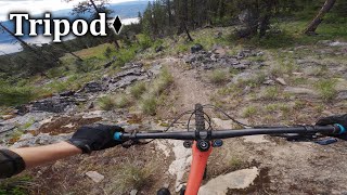
As technical as you want to make it. Vistas that go for days.
Most users take the Tripod North after the cattleguard as Tripod (Main) simply terminates on Riddle Rd

Access Info

From Sidewinder, there is a nearly obvious fork in the trail (Sidewinder makes a hard 90 degree turn). When climbing, Tripod is on the right of the T-intersection heading southwest.

Local Trail Association
Traditionally Indigenous Territory

Recent Activity on Trail

Past Week
  • 0 rides
  •  
6 Months
  • 3 rides
  • 17 miles avg distance
All
  • 39 rides
  • Last: Jun 20, 2026
c1c2c3c4
January
February
March
April
May
June
July
August
September
October
November
December
update trails status or condition

Tripod Trail Reports

statusdatedescription
Apr 28, 2026 @ 12:55pm (America/Vancouver)
Apr 28, 2026
Several new tree down from last storms.
Apr 16, 2026 @ 2:13pm (America/Vancouver)
Apr 16, 2026
Upper Tripod cleared.
Nov 15, 2025 @ 3:52pm (America/Vancouver)
Nov 15, 2025
Tree down at the start of Tripod.
Oct 8, 2025 @ 12:12pm (America/Vancouver)
Oct 8, 2025
big tree down 24" dia will need a big saw
May 17, 2025 @ 4:20pm
May 17, 2025
All deadfall has been cleared as of May 17.
more »
Status:
on Apr 28, 2026
Avg: 3.89 (4 votes)
Your vote: 0

view (245)
close
3D
Trail Conditions
  • Unknown
  • Snow Groomed
  • Snow Packed
  • Snow Covered
  • Snow Cover Partial
  • Freeze/thaw Cycle
  • Icy
  • Prevalent Mud
  • Wet
  • Variable
  • Ideal
  • Dry
  • Very Dry
Trail Flow (Ridden Direction)
Trailforks scans users ridelogs to determine the most popular direction each trail is ridden. A good flowing trail network will have most trails flowing in a single direction according to their intension.
The colour categories are based on what percentage of riders are riding a trail in its intended direction.
  • > 96%
  • > 90%
  • > 80%
  • > 70%
  • > 50%
  • < 50%
  • bi-directional trail
  • no data
Trail Last Ridden
Trailforks scans ridelogs to determine the last time a trail was ridden.
  • < 2 days
  • < 1 week
  • < 2 weeks
  • < 1 month
  • < 6 months
  • > 6 months
Trail Ridden Direction
The intended direction a trail should be ridden.
  • Downhill Only
  • Downhill Primary
  • Both Directions
  • Uphill Primary
  • Uphill Only
  • One Direction
Contribute Details
Colors indicate trail is missing specified detail.
  • Description
  • Photos
  • Description & Photos
  • Videos
Trail Popularity ?
Trailforks scans ridelogs to determine which trails are ridden the most in the last 9 months. Trails are compared with nearby trails in the same city region with a possible 25 colour shades. Think of this as a heatmap, more rides = more kinetic energy = warmer colors.
  • most popular
  • popular
  • less popular
  • not popular
ATV/ORV/OHV Filter
Max Vehicle Width
inches
US Cell Coverage
Legend
cell carrier legend

Radar Time
Activity Recordings
Trailforks uses anonymized public activity data. ?
Activity Recordings
Trailforks uses anonymized public activity data. ?
Personal Heatmap
Activity Types
all / none
Options
2
Date range month
Winter Trails
Warning A routing network for winter maps does not exist. Selecting trails using the winter trails layer has been disabled.
Missing Trails
Most Popular
Least Popular
Trails are colored based on popularity. The more popular a trail is, the more red. Less popular trails trend towards green.
Jump Magnitude Heatmap
Heatmap of where riders jump on trails. Zoom in to see individual jumps, click circles to view jump details.
BC Backroad Status

Service Road Atlas is a free to use, community-driven service for viewing and creating reports on the numerous back-country service roads around B.C. and Alberta.

map legend
Slope Aspect
Direction the slope faces
Flat N NE E SE S SW W NW
Trails Deemphasized
Trails are shown in grey.
disable
Only show trails with no bike usage.
Enable
Suggested Layers
Based on selected activity type

    Save the current map location and zoom level as your default home location whenever this page is loaded.

    Save
        Directions to tripod trailhead (49.576760, -119.529110)

        Photos

        16 more »
        84 |
        Apr 23, 2017 @ 8:18pm
        Apr 23, 2017
        84 |
        Apr 23, 2017 @ 8:18pm
        Apr 23, 2017
        61 |
        Apr 23, 2017 @ 8:17pm
        Apr 23, 2017
        65 |
        Apr 23, 2017 @ 8:17pm
        Apr 23, 2017

        Videos

        7 more »
        youtuber Tripod North | This is where we keep all the...
        4:08 | 453 | Aug 30, 2019 , Penticton
        Tripod - Three Blind Mice
        8:04 | 55 | Oct 5, 2024 , Penticton
        It's BC, Bud Pt. II Gillard
        2:25 | 880 | Jul 3, 2013 , Penticton
        A Visit
        2:21 | 462 | Jun 26, 2012 , Penticton

        Routes with this trail

        18 miles 3,318 ft 15 Loop Race
        This is the expect long course route for the 2026 PeachDuro happening September 13th, 2026

        Trail Products

        4 Reviews & Comments


        We hope you've been enjoying Trailforks!

        Create a FREE account to view trail comments and much more.

        • By smokeTF Pro Simpcw & contributors
        • #19075 - 2,305 views

        Frequently Asked Questions About Tripod

        Where is Tripod located?
        Tripod is located in Three Blind Mice, Penticton, British Columbia, Canada. It is part of the Three Blind Mice trail network. The trailhead is located at coordinates 49.57676, -119.52911.
        How hard is Tripod?
        Tripod is rated as Blue difficulty. The physical rating is Easy. The average grade is 7.385%.
        What is the elevation gain for Tripod?
        Tripod has 57 ft of elevation gain. The trail has 447 ft of elevation descent. The elevation ranges from 3,432 ft to 3,858 ft.
        Is Tripod a point to point trail?
        Yes, Tripod is a point to point trail. The direction is Downhill Only. The trail type is singletrack.

        Hit the Trail

        Open in App

        Get this trail on your phone instantly.
        open trail in app

        Download Trail

        Save to wishlist, Garmin & download.
        save the trail

        Find Related Routes

        Find routes and users activities that include this trail.
        find routes for this trail

        You must enter a description before submitting.