more stats
2.5 miles
Distance
414 ft
Climb
-111 ft
Descent
00:32:04
Avg time
304 ft
Altitude change
4,576 ft
Altitude min
4,908 ft
Altitude max
4,603 ft
Altitude start
4,908 ft
Altitude end
2.3%
Grade
-16%
Grade max
18%
Grade min
2 miles
Distance climb
3,222 ft
Distance down
991 ft
Distance flat
00:32:04
Avg time

Troy Built Upper Details

  • Activities
    • Mountain Bike
    • Hike
    • Trail Running
  • Riding Area
    Kokopelli Loops
    Loma, Colorado
  • Difficulty Rating
  • Voted Difficulty
    Blue (1 vote)
  • Local Popularity
    45 in Mountain Biking [+]
    • 60 in Trail Running
    • 5 in Hiking
  • Global Ranking
    #104701 in Mountain Biking [+]
    • #94791 in Trail Running
    • #312600 in Hiking
  • Hiking SAC Scale
    T1 Hiking
  • Trail Type
    Singletrack
  • Direction
    Both Directions
  • Dogs Allowed
    Yes
  • eBike Allowed
  • Land Owner
    BLM

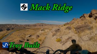
Troy Built is a great climb either direction with fun downhill, some excellently tricky obstacles, particularly in the area closer to I-70. This trail is easily accessed, is a connector to Kokopelli, and can be linked as a loop with Lion's (double track Jeep trail), or Mack Ridge. Views are excellent and varied, overlooking both the river and rail road tracks.

Local Trail Association
Traditionally Indigenous Territory

Recent Activity on Trail

Past Week
  • 1 rides
  • 31 miles average
6 Months
  • 61 rides
  • 24 miles avg distance
All
  • 384 rides
  • Last: Jun 28, 2026
c1c2c3c4
January
February
March
April
May
June
July
August
September
October
November
December
update trails status or condition

Troy Built Upper Trail Reports

Status:
on May 21, 2026
Dry
Avg: 3.99 (3 votes)
Your vote: 0

view (1,647)
close
3D
Trail Conditions
  • Unknown
  • Snow Groomed
  • Snow Packed
  • Snow Covered
  • Snow Cover Partial
  • Freeze/thaw Cycle
  • Icy
  • Prevalent Mud
  • Wet
  • Variable
  • Ideal
  • Dry
  • Very Dry
Trail Flow (Ridden Direction)
Trailforks scans users ridelogs to determine the most popular direction each trail is ridden. A good flowing trail network will have most trails flowing in a single direction according to their intension.
The colour categories are based on what percentage of riders are riding a trail in its intended direction.
  • > 96%
  • > 90%
  • > 80%
  • > 70%
  • > 50%
  • < 50%
  • bi-directional trail
  • no data
Trail Last Ridden
Trailforks scans ridelogs to determine the last time a trail was ridden.
  • < 2 days
  • < 1 week
  • < 2 weeks
  • < 1 month
  • < 6 months
  • > 6 months
Trail Ridden Direction
The intended direction a trail should be ridden.
  • Downhill Only
  • Downhill Primary
  • Both Directions
  • Uphill Primary
  • Uphill Only
  • One Direction
Contribute Details
Colors indicate trail is missing specified detail.
  • Description
  • Photos
  • Description & Photos
  • Videos
Trail Popularity ?
Trailforks scans ridelogs to determine which trails are ridden the most in the last 9 months. Trails are compared with nearby trails in the same city region with a possible 25 colour shades. Think of this as a heatmap, more rides = more kinetic energy = warmer colors.
  • most popular
  • popular
  • less popular
  • not popular
ATV/ORV/OHV Filter
Max Vehicle Width
inches
US Cell Coverage
Legend
cell carrier legend

Radar Time
Activity Recordings
Trailforks uses anonymized public activity data. ?
Activity Recordings
Trailforks uses anonymized public activity data. ?
Personal Heatmap
Activity Types
all / none
Options
2
Date range month
Winter Trails
Warning A routing network for winter maps does not exist. Selecting trails using the winter trails layer has been disabled.
Missing Trails
Most Popular
Least Popular
Trails are colored based on popularity. The more popular a trail is, the more red. Less popular trails trend towards green.
Jump Magnitude Heatmap
Heatmap of where riders jump on trails. Zoom in to see individual jumps, click circles to view jump details.
BC Backroad Status

Service Road Atlas is a free to use, community-driven service for viewing and creating reports on the numerous back-country service roads around B.C. and Alberta.

map legend
Slope Aspect
Direction the slope faces
Flat N NE E SE S SW W NW
Trails Deemphasized
Trails are shown in grey.
disable
Only show trails with no bike usage.
Enable
Suggested Layers
Based on selected activity type

    Save the current map location and zoom level as your default home location whenever this page is loaded.

    Save
        Directions to troy-built-upper trailhead (39.214950, -108.899510)

        Photos

        2 more »
        62 |
        Oct 12, 2025 @ 8:14pm
        Oct 12, 2025
        42 |
        Oct 12, 2025 @ 8:14pm
        Oct 12, 2025

        Videos

        1 more »
        youtuber Mack Ridge and Troy Built
        16:42 | 191 | Feb 20, 2024 , Loma

        Routes with this trail

        30 miles 3,928 ft 14
        2026 Courses Coming Soon The 50K takes runners on the stunning Loops in the Mack Ridge area, with a bonus...
        365 miles 36,922 ft 42 Loop
        This is the 2025 Grand Loop route

        Reviews / Comments

        No reviews yet, be the first to write a review or ask a question.
        Use trail reports to comment on trail conditions.


        We hope you've been enjoying Trailforks!

        Create a FREE account to view trail comments and much more.

        • By msmcfateTF Pro TRAILFORKS & contributors
        • #341134 - 1,108 views

        Frequently Asked Questions About Troy Built Upper

        Where is Troy Built Upper located?
        Troy Built Upper is located in Kokopelli Loops, Loma, Colorado, United States. It is part of the Kokopelli Loops trail network. The trailhead is located at coordinates 39.21495, -108.89951.
        How hard is Troy Built Upper?
        Troy Built Upper is rated as Blue difficulty. The average grade is 2.3%.
        What is the elevation gain for Troy Built Upper?
        Troy Built Upper has 414 ft of elevation gain. The trail has 111 ft of elevation descent. The elevation ranges from 4,576 ft to 4,908 ft.
        Is Troy Built Upper a point to point trail?
        Troy Built Upper is not a point to point trail. The direction is Both Directions. The trail type is singletrack.

        Hit the Trail

        Open in App

        Get this trail on your phone instantly.
        open trail in app

        Download Trail

        Save to wishlist, Garmin & download.
        save the trail

        Find Related Routes

        Find routes and users activities that include this trail.
        find routes for this trail

        You must enter a description before submitting.