
more stats
1.1 miles
Distance
54 ft
Climb
-559 ft
Descent
00:12:34
Avg time
-506 ft
Altitude change
4,070 ft
Altitude min
4,588 ft
Altitude max
4,588 ft
Altitude start
4,082 ft
Altitude end
-8.492%
Grade
-26.51%
Grade max
30.785%
Grade min
490 ft
Distance climb
1 mile
Distance down
152 ft
Distance flat
00:12:34
Avg time

Upper Ed Details

  • Activities
    • Mountain Bike
    • Hike
    • Trail Running
  • Riding Area
    King Eddie Plateau
    Vernon, British Columbia
  • Difficulty Rating
  • Local Popularity
    60 in Mountain Biking [+]
    • 55 in Trail Running
    • 55 in Hiking
  • Global Ranking
    #86530 in Mountain Biking [+]
    • #145928 in Trail Running
    • #146417 in Hiking
  • Provincial Ranking
    #4,357 in Mountain Biking · British Columbia [+]
    • #8,595 in Trail Running
    • #8,697 in Hiking
  • Trail Type
    Singletrack
  • Bike Type
    DH, AM
  • Direction
    Downhill Primary
    Popular Direction Shown
  • Season
    May to November
  • Dogs Allowed
    Yes
  • TTFs on Trail
    Rock Face, Rock Garden

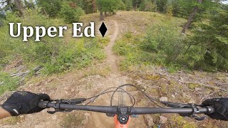
Upper Ed is a great addition to the classic all mountain trail Big Ed. Some steeper rocky features near the top and one techy rock garden, then crosses over the road dropping down to the intersection of Tombstone, Big Ed, and Teddy Bear's Picnic.

Access Info

Shuttle or Pedal

Tags

Local Trail Association

Recent Activity on Trail

Past Week
  • 1 rides
  • 9 miles average
6 Months
  • 7 rides
  • 9 miles avg distance
All
  • 57 rides
  • Last: Nov 8, 2026
c1c2c3c4
January
February
March
April
May
June
July
August
September
October
November
December
update trails status or condition

Upper Ed Trail Reports

statusdatedescription
May 1, 2026 @ 8:43pm (America/Vancouver)
May 1, 2026
All trees cleared. Some limbing done. Trail is good to go!
Apr 27, 2026 @ 6:43pm (America/Vancouver)
Apr 27, 2026
One big tree down and a whole bunch of little ones
Apr 12, 2026 @ 7:25pm (America/Vancouver)
Apr 12, 2026
Jul 12, 2025 @ 9:50am
Jul 12, 2025
May 5, 2025 @ 4:59pm
May 5, 2025
Trees are cleared, branches picked up, trail bed is in excellent shape, good to go!
more »
Status:
on May 1, 2026
Ideal
Avg: 4.15 (7 votes)
Your vote: 0

view (354)
close
      Directions to upper-ed trailhead (50.175630, -119.209071)

      Photos

      2 more »
      mtb
      374 |
      Jun 11, 2017 @ 8:30pm
      Jun 11, 2017
      report
      mtb
      197 |
      Nov 7, 2019 @ 3:30pm
      Nov 7, 2019

      Videos

      1 more »
      Upper Ed - Kalamalka Park
      mtb
      6:47 | 303 | Sep 10, 2023 , Vernon

      Routes with this trail

      more »
      79 miles • 10,654 ft • 102 • Point to Point •
      Connect all the networks in the Vernon area, exact trails can be changed but must ride entire route, no...
      21 miles • 4,042 ft • 46 •
      One option if we get approval for the repeater (reroute of HRT). If not then we could use cj express far...
      16 miles • 3,207 ft • 43 • Point to Point •
      good times without big climbs
      4.3 ★★★★★
      7 Ratings
      5 ★ 71%
      4 ★ 14%
      3 ★
      2 ★
      1 ★ 14%

      2 Reviews & Comments

      jasonw jasonw
      Ok trail. Nothing to write home about. Mostly a blue trail.

      We hope you've been enjoying Trailforks!

      Create a FREE account to view all trail reviews and much more.

      • By markeedTF Pro NOCS & contributors
      • #81209 - 3,036 views

      Frequently Asked Questions

      ▼ Where is Upper Ed located?
      Upper Ed is located in King Eddie Plateau, Vernon, British Columbia, Canada. It is part of the King Eddie Plateau trail network. The trailhead is located at coordinates 50.17563, -119.20907.
      ▼ How hard is Upper Ed?
      Upper Ed is rated as Black Diamond difficulty. The average grade is 8.492%.
      ▼ What is the elevation gain for Upper Ed?
      Upper Ed has 54 ft of elevation gain. The trail has 559 ft of elevation descent. The elevation ranges from 4,070 ft to 4,588 ft.
      ▼ Is Upper Ed a point to point trail?
      Upper Ed is not a point to point trail. The direction is Downhill Primary. The trail type is singletrack.
      ▼ How long is Upper Ed?
      Upper Ed is 1.1 miles long. The trail type is singletrack.
      ▼ Are dogs allowed on Upper Ed?
      Yes, dogs are allowed on Upper Ed. Please keep dogs on a leash where required and clean up after them.
      ▼ When is the best time of year to ride Upper Ed?
      Based on activity log data, the most popular months to ride Upper Ed are:
      • May (8 activities)
      • June (4 activities)
      • July (4 activities)
      Check the reports page for current trail conditions.
      ▼ How do I access Upper Ed? Where is the closest parking trailhead?
      The closest parking and trailhead locations to Upper Ed are: View all parking locations in the area.
      ▼ How long does it take to ride Upper Ed?
      Based on recorded activities, it takes an average of 13 minutes to ride Upper Ed. The trail is 1.1 miles long. Actual times will vary based on fitness level, conditions, and pace. View recent activity logs for more details.
      ▼ How busy is Upper Ed?
      Upper Ed is a moderately popular trail. There have been 370 recorded activities on this trail. The trail has received 354 check-ins. View recent activity on this trail.

      Hit the Trail

      Open in App

      Get this trail on your phone instantly.

      open trail in app

      Download Trail

      Save to wishlist, Garmin & download.
      save the trail

      Find Related Routes

      Find routes and users activities that include this trail.
      find routes for this trail

      You must enter a description before submitting.


