more stats
3,484 ft
Distance
17 ft
Climb
-408 ft
Descent
00:05:18
Avg time
-391 ft
Altitude change
3,009 ft
Altitude min
3,417 ft
Altitude max
3,417 ft
Altitude start
3,025 ft
Altitude end
-11.2%
Grade
-52%
Grade max
11.6%
Grade min
184 ft
Distance climb
3,301 ft
Distance down
00:05:18
Avg time

Upper Godey Details

  • Activities
    • Mountain Bike
    • E-Bike
    • Hike
    • Trail Running
  • Riding Area
    Iron Mountain
    Merritt, British Columbia
  • Difficulty Rating
  • Local Popularity
    85 in Mountain Biking [+]
    • 60 in E-Biking
    • 5 in Trail Running
    • 5 in Hiking
  • Global Ranking
    #55187 in Mountain Biking [+]
    • #40789 in E-Biking
    • #137124 in Trail Running
    • #131493 in Hiking
  • Trail Type
    Singletrack
  • Direction
    Downhill Primary
    Popular Direction Shown
  • Dogs Allowed
    Yes
  • eBike Allowed

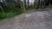
This trail has the feeling of being an original mountain bike trail.
It makes good use of the terrain to provide some steep sections, some flow and some technical features.
There is nothing super tough on this upper section, but it flows into Godey which does have some more challenging technical sections.

Local Trail Association

Recent Activity on Trail

Past Week
  • 0 rides
  •  
6 Months
  • 12 rides
  • 48 miles avg distance
All
  • 131 rides
  • Last: Jun 13, 2026
c1c2c3c4
January
February
March
April
May
June
July
August
September
October
November
December
update trails status or condition

Upper Godey Trail Reports

statusdatedescription
May 24, 2026 @ 12:33pm (America/Vancouver)
May 24, 2026
reporter
May 18, 2025 @ 9:10pm
May 18, 2025
cleared of blowdown--riding good
May 16, 2025 @ 10:55am
May 16, 2025
Tree down across trail at chest level
May 11, 2025 @ 2:02pm
May 11, 2025
not recommended
Jul 9, 2023 @ 10:07pm
Jul 9, 2023
Large tree blown down over the trail in the first 300m. Big enough a chainsaw will be needed. Overall the trail is in good shape but dry. The...
more »
Status:
on May 24, 2026
Ideal
Avg: 4.32 (6 votes)
Your vote: 0

view (565)
close
3D
Trail Conditions
  • Unknown
  • Snow Groomed
  • Snow Packed
  • Snow Covered
  • Snow Cover Partial
  • Freeze/thaw Cycle
  • Icy
  • Prevalent Mud
  • Wet
  • Variable
  • Ideal
  • Dry
  • Very Dry
Trail Flow (Ridden Direction)
Trailforks scans users ridelogs to determine the most popular direction each trail is ridden. A good flowing trail network will have most trails flowing in a single direction according to their intension.
The colour categories are based on what percentage of riders are riding a trail in its intended direction.
  • > 96%
  • > 90%
  • > 80%
  • > 70%
  • > 50%
  • < 50%
  • bi-directional trail
  • no data
Trail Last Ridden
Trailforks scans ridelogs to determine the last time a trail was ridden.
  • < 2 days
  • < 1 week
  • < 2 weeks
  • < 1 month
  • < 6 months
  • > 6 months
Trail Ridden Direction
The intended direction a trail should be ridden.
  • Downhill Only
  • Downhill Primary
  • Both Directions
  • Uphill Primary
  • Uphill Only
  • One Direction
Contribute Details
Colors indicate trail is missing specified detail.
  • Description
  • Photos
  • Description & Photos
  • Videos
Trail Popularity ?
Trailforks scans ridelogs to determine which trails are ridden the most in the last 9 months. Trails are compared with nearby trails in the same city region with a possible 25 colour shades. Think of this as a heatmap, more rides = more kinetic energy = warmer colors.
  • most popular
  • popular
  • less popular
  • not popular
ATV/ORV/OHV Filter
Max Vehicle Width
inches
US Cell Coverage
Legend
cell carrier legend

Radar Time
Activity Recordings
Trailforks uses anonymized public activity data. ?
Activity Recordings
Trailforks uses anonymized public activity data. ?
Personal Heatmap
Activity Types
all / none
Options
2
Date range month
Winter Trails
Warning A routing network for winter maps does not exist. Selecting trails using the winter trails layer has been disabled.
Missing Trails
Most Popular
Least Popular
Trails are colored based on popularity. The more popular a trail is, the more red. Less popular trails trend towards green.
Jump Magnitude Heatmap
Heatmap of where riders jump on trails. Zoom in to see individual jumps, click circles to view jump details.
BC Backroad Status

Service Road Atlas is a free to use, community-driven service for viewing and creating reports on the numerous back-country service roads around B.C. and Alberta.

map legend
Slope Aspect
Direction the slope faces
Flat N NE E SE S SW W NW
Trails Deemphasized
Trails are shown in grey.
disable
Only show trails with no bike usage.
Enable
Suggested Layers
Based on selected activity type

    Save the current map location and zoom level as your default home location whenever this page is loaded.

    Save
        Directions to upper-godey trailhead (50.068570, -120.726850)

        Photos

        10 more »
        34 |
        May 11, 2025 @ 5:14pm
        May 11, 2025
        69 |
        Apr 22, 2023 @ 11:33pm
        Apr 22, 2023
        88 |
        May 5, 2019 @ 1:55pm
        May 5, 2019
        126 |
        Jun 10, 2018 @ 1:58pm
        Jun 10, 2018

        Videos

        2 more »
        Godey Trail Merritt BC
        779 | Nov 7, 2016 , Merritt
        Not the best way to start a ride
        0:23 | 806 | Dec 4, 2017 , Merritt

        Routes with this trail

        35 miles 5,334 ft 10 Loop
        THE MERRITT CROWN 120KM, 60KM & RELAY 3,000M of Elevation. 12-Hour Time Limit. The 7th Annual MTB...
        13 miles 2,592 ft 8
        Some of Merritt's finest single-track, including Creek, rmation, and .
        3.3 73 miles 10 ft 21 Loop Race
        The full Merritt Crown Route featuring plenty of singletrack and top trails. 120km 3000m Can you complete...

        3 Reviews & Comments


        We hope you've been enjoying Trailforks!

        Create a FREE account to view trail comments and much more.

        • By canadakaTF Pro Trailforks & contributors
        • #32860 - 2,669 views

        Frequently Asked Questions About Upper Godey

        Where is Upper Godey located?
        Upper Godey is located in Iron Mountain, Merritt, British Columbia, Canada. It is part of the Iron Mountain trail network. The trailhead is located at coordinates 50.06857, -120.72685.
        How hard is Upper Godey?
        Upper Godey is rated as Black Diamond difficulty. The average grade is 11.2%.
        What is the elevation gain for Upper Godey?
        Upper Godey has 17 ft of elevation gain. The trail has 408 ft of elevation descent. The elevation ranges from 3,009 ft to 3,417 ft.
        Is Upper Godey a point to point trail?
        Upper Godey is not a point to point trail. The direction is Downhill Primary. The trail type is singletrack.

        Hit the Trail

        Open in App

        Get this trail on your phone instantly.
        open trail in app

        Download Trail

        Save to wishlist, Garmin & download.
        save the trail

        Find Related Routes

        Find routes and users activities that include this trail.
        find routes for this trail

        You must enter a description before submitting.