more stats
2,087 ft
Distance
-98 ft
Descent
00:03:37
Avg time
-98 ft
Altitude change
558 ft
Altitude min
656 ft
Altitude max
656 ft
Altitude start
558 ft
Altitude end
-4.7%
Grade
-13.4%
Grade max
0.4%
Grade min
1,368 ft
Distance down
719 ft
Distance flat
00:03:37
Avg time

Upper Springboard Details

  • Activities
    • Mountain Bike
  • Riding Area
    Lord Hill Regional Park
    Snohomish, Washington
  • Difficulty Rating
  • Voted Difficulty
    Blue (2 votes)
  • Local Popularity
    90 in Mountain Biking
  • Global Ranking
    #36971 in Mountain Biking
  • Trail Type
    Singletrack
  • Bike Type
    AM, XC
  • Direction
    Downhill Only
    Popular Direction Shown
  • Climb Difficulty
    Blue
  • Physical Rating
    Moderate
  • Dogs Allowed
    Yes
  • eBike Allowed
  • TTFs on Trail
    Berm, Drop, Jump
  • Ride in Rain
    Yes
  • Land Owner
    Snohomish County Parks & Recreation

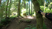
Fun flowing, downhill slanting trail with occasional roots, smooth singletrack and good corners. Trail starts with slight XC climb then descends down to the access trail. Near the bottom there's a larger drop off the side of the main trail that can be used as a shortcut. If you decide not to take the shortcut, there's a small drop and a small table top jump on the main trail which are optional.

Local Trail Association
Traditionally Indigenous Territory

Recent Activity on Trail

Past Week
  • 17 rides
  • 9 miles average
6 Months
  • 301 rides
  • 8 miles avg distance
All
  • 2,667 rides
  • Last: Jun 14, 2026
c1c2c3c4
January
February
March
April
May
June
July
August
September
October
November
December
update trails status or condition

Upper Springboard Trail Reports

statusdatedescription
Jun 5, 2026 @ 8:00pm (America/Los_Angeles)
Jun 5, 2026
Brushed/blown
Jun 2, 2026 @ 8:25am (America/Vancouver)
Jun 2, 2026
Awesome, even on the roots! [L=https://www.evergreenmtb.org/trails/ride-reports/rr-9626]Evergreen MTB Report[/L]
Apr 25, 2026 @ 1:49pm (America/Vancouver)
Apr 25, 2026
Apr 17, 2026 @ 1:42pm (America/Vancouver)
Apr 17, 2026
Some soft spots. [L=https://www.evergreenmtb.org/trails/ride-reports/rr-9557]Evergreen MTB Report[/L]
Apr 4, 2026 @ 5:31am (America/Los_Angeles)
Apr 4, 2026
more »
Status:
on Jun 5, 2026
Ideal
Avg: 4.31 (17 votes)
Your vote: 0

view (8,324)
close
3D
Trail Conditions
  • Unknown
  • Snow Groomed
  • Snow Packed
  • Snow Covered
  • Snow Cover Partial
  • Freeze/thaw Cycle
  • Icy
  • Prevalent Mud
  • Wet
  • Variable
  • Ideal
  • Dry
  • Very Dry
Trail Flow (Ridden Direction)
Trailforks scans users ridelogs to determine the most popular direction each trail is ridden. A good flowing trail network will have most trails flowing in a single direction according to their intension.
The colour categories are based on what percentage of riders are riding a trail in its intended direction.
  • > 96%
  • > 90%
  • > 80%
  • > 70%
  • > 50%
  • < 50%
  • bi-directional trail
  • no data
Trail Last Ridden
Trailforks scans ridelogs to determine the last time a trail was ridden.
  • < 2 days
  • < 1 week
  • < 2 weeks
  • < 1 month
  • < 6 months
  • > 6 months
Trail Ridden Direction
The intended direction a trail should be ridden.
  • Downhill Only
  • Downhill Primary
  • Both Directions
  • Uphill Primary
  • Uphill Only
  • One Direction
Contribute Details
Colors indicate trail is missing specified detail.
  • Description
  • Photos
  • Description & Photos
  • Videos
Trail Popularity ?
Trailforks scans ridelogs to determine which trails are ridden the most in the last 9 months. Trails are compared with nearby trails in the same city region with a possible 25 colour shades. Think of this as a heatmap, more rides = more kinetic energy = warmer colors.
  • most popular
  • popular
  • less popular
  • not popular
ATV/ORV/OHV Filter
Max Vehicle Width
inches
US Cell Coverage
Legend
cell carrier legend

Radar Time
Activity Recordings
Trailforks uses anonymized public activity data. ?
Activity Recordings
Trailforks uses anonymized public activity data. ?
Personal Heatmap
Activity Types
all / none
Options
2
Date range month
Winter Trails
Warning A routing network for winter maps does not exist. Selecting trails using the winter trails layer has been disabled.
Missing Trails
Most Popular
Least Popular
Trails are colored based on popularity. The more popular a trail is, the more red. Less popular trails trend towards green.
Jump Magnitude Heatmap
Heatmap of where riders jump on trails. Zoom in to see individual jumps, click circles to view jump details.
BC Backroad Status

Service Road Atlas is a free to use, community-driven service for viewing and creating reports on the numerous back-country service roads around B.C. and Alberta.

map legend
Slope Aspect
Direction the slope faces
Flat N NE E SE S SW W NW
Trails Deemphasized
Trails are shown in grey.
disable
Only show trails with no bike usage.
Enable
Suggested Layers
Based on selected activity type

    Save the current map location and zoom level as your default home location whenever this page is loaded.

    Save
        Directions to upper-springboard trailhead (47.856660, -122.058750)

        Photos

        20 more »
        305 |
        Aug 23, 2021 @ 7:01pm
        Aug 23, 2021
        312 |
        Feb 9, 2020 @ 2:36pm
        Feb 9, 2020
        344 |
        Feb 9, 2020 @ 2:34pm
        Feb 9, 2020
        391 |
        Feb 9, 2020 @ 2:32pm
        Feb 9, 2020

        Videos

        5 more »
        Upper Springboard | Mountain Bike Lord Hill, WA
        0:20 | 1106 | Apr 21, 2022 , Snohomish
        Lord Hill Regional Park | Upper Springboard |...
        5:09 | 743 | Jul 13, 2020 , Snohomish
        Upper Springboard Trail, Lord Hill Park -...
        0:20 | 671 | Nov 3, 2019 , Snohomish
        An almost really bad crash
        0:19 | 150 | May 28, 2023 , Snohomish

        Routes with this trail

        10 miles 1,380 ft 19
        This route combines both downhill and XC trails to create the 3 longest downhill runs in the park. Expect...
        3.0 8 miles 1,392 ft 20
        This takes the easiest climb from the park's south entrance to access the core mountain bike trails. The...
        8 miles 1,033 ft 20
        Focusing on downhill trails. Upper and , Meat Cutter, Golden Eye, , .

        5 Reviews & Comments


        We hope you've been enjoying Trailforks!

        Create a FREE account to view trail comments and much more.

        • By jcowanTF Pro & contributors
        • #25071 - 5,242 views

        Frequently Asked Questions About Upper Springboard

        Where is Upper Springboard located?
        Upper Springboard is located in Lord Hill Regional Park, Snohomish, Washington, United States. It is part of the Lord Hill Regional Park trail network. The trailhead is located at coordinates 47.85666, -122.05875.
        How hard is Upper Springboard?
        Upper Springboard is rated as Blue difficulty. The physical rating is Moderate. The average grade is 4.7%. The climb difficulty is rated Blue.
        What is the elevation gain for Upper Springboard?
        The trail has 98 ft of elevation descent. The elevation ranges from 558 ft to 656 ft.
        Is Upper Springboard a point to point trail?
        Yes, Upper Springboard is a point to point trail. The direction is Downhill Only. The trail type is singletrack.

        Hit the Trail

        Open in App

        Get this trail on your phone instantly.
        open trail in app

        Download Trail

        Save to wishlist, Garmin & download.
        save the trail

        Find Related Routes

        Find routes and users activities that include this trail.
        find routes for this trail

        You must enter a description before submitting.