1.1 miles
Distance
50 ft
Climb
-463 ft
Descent
00:10:20
Avg time

Ursus Details

  • Activities
    • Mountain Bike
    • E-Bike
    • Hike
    • Trail Running
  • Riding Area
    Jakes Rocks
    Warren, Pennsylvania
  • Difficulty Rating
  • Voted Difficulty
    Black Diamond (1 vote)
  • Trail Type
    Singletrack
  • Direction
    Downhill Primary
    Popular direction shown
  • Climb Difficulty
    Black Diamond
  • Physical Rating
    Hard
  • Dogs Allowed
    Yes
  • eBike Allowed
  • TTFs on Trail
    Berm, Bridge, Drop, Jump, Rock Garden
  • Global Ranking
    #5768 in Mountain Biking [+]
    • #34948 in Hiking
  • Local Popularity
    95 in Mountain Biking [+]
    • 85 in E-Biking
    • 85 in Trail Running
    • 65 in Hiking
  • Land Owner
    USFS

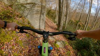
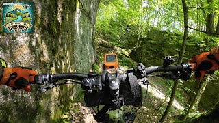
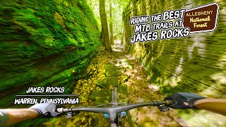
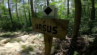
Ursus (Latin for bear) is one of the more technical and difficult trails at Jake's Rocks. This trail contains jumps, drops (nearly all rollable), doubles, rock rollers, and wooden bridges.

From the top down, first there is a rock garden into a switchback, then a few jumps, into a rock roller, another switchback, and optional drops on the right hand side. It continues like this the whole way down This trail is more of a technical flow trail, with higher trail speeds than a trail like deerfoot or Bent run.

About halfway down you will see a sign that says "Drops Left", this means that in general the larger drops are to the left side of the main trail, however, they are nearly all rollable. As always do a run to scope out the trail before fully committing to trail features!

The end of the descent is marked by a longer wooden bridge, after this is a mild climb out to the junction with Dew Drop.

This is arguably the best or one of the best trails at Jake's Rocks, enjoy!

Local Trail Association
Traditionally Indigenous Territory
More Stats for Ursus multi-use trail trail
  • Altitude change
    -413 ft
  • Altitude min
    1,456 ft
  • Altitude max
    1,921 ft
  • Altitude start
    1,921 ft
  • Altitude end
    1,506 ft
  • Grade
    -7.2%
  • Grade max
    -50.6%
  • Grade min
    12.4%
  • Distance climb
    860 ft
  • Distance down
    4,790 ft
  • Distance flat
    75 ft
  • Avg time
    00:10:20
  • Avg reverse time
    00:23:38
  • view trail stats
Status:
on Nov 1, 2024
Ideal
Avg: 4.69 (17 votes)
Your vote: 0

view (1,941)
close
3D
Trail Conditions
  • Unknown
  • Snow Groomed
  • Snow Packed
  • Snow Covered
  • Snow Cover Partial
  • Freeze/thaw Cycle
  • Icy
  • Prevalent Mud
  • Wet
  • Variable
  • Ideal
  • Dry
  • Very Dry
Trail Flow (Ridden Direction)
Trailforks scans users ridelogs to determine the most popular direction each trail is ridden. A good flowing trail network will have most trails flowing in a single direction according to their intension.
The colour categories are based on what percentage of riders are riding a trail in its intended direction.
  • > 96%
  • > 90%
  • > 80%
  • > 70%
  • > 50%
  • < 50%
  • bi-directional trail
  • no data
Trail Last Ridden
Trailforks scans ridelogs to determine the last time a trail was ridden.
  • < 2 days
  • < 1 week
  • < 2 weeks
  • < 1 month
  • < 6 months
  • > 6 months
Trail Ridden Direction
The intended direction a trail should be ridden.
  • Downhill Only
  • Downhill Primary
  • Both Directions
  • Uphill Primary
  • Uphill Only
  • One Direction
Contribute Details
Colors indicate trail is missing specified detail.
  • Description
  • Photos
  • Description & Photos
  • Videos
Trail Popularity ?
Trailforks scans ridelogs to determine which trails are ridden the most in the last 9 months. Trails are compared with nearby trails in the same city region with a possible 25 colour shades. Think of this as a heatmap, more rides = more kinetic energy = warmer colors.
  • most popular
  • popular
  • less popular
  • not popular
ATV/ORV/OHV Filter
Max Vehicle Width
inches
US Cell Coverage
Legend
cell carrier legend

Radar Time
x Activity Recordings
Trailforks users anonymized public ridelogs from the past 6 months.
  • mountain biking recent
  • mountain biking (>6 month)
  • hiking (1 year)
  • moto (1 year)
Activity Recordings
Trailforks users anonymized public skilogs from the past 12 months.
  • Downhill Ski
  • Backcountry Ski
  • Nordic Ski
  • Snowmobile
Winter Trails
Warning A routing network for winter maps does not exist. Selecting trails using the winter trails layer has been disabled.
x Missing Trails
Most Popular
Least Popular
Trails are colored based on popularity. The more popular a trail is, the more red. Less popular trails trend towards green.
Jump Magnitude Heatmap
Heatmap of where riders jump on trails. Zoom in to see individual jumps, click circles to view jump details.
Trails Deemphasized
Trails are shown in grey.
disable
Only show trails with NO bikes.
enable

Save the current map location and zoom level as your default home location whenever this page is loaded.

Save
      Directions to ursus trailhead (41.822490, -78.975130)
      update trails status or condition

      Ursus Trail Reports

      statusdatedescription
      Nov 1, 2024 @ 10:23am
      Nov 1, 2024
      What a great trails.. nice descent with enough flow and enough chunk.
      Nov 1, 2024 @ 10:23am
      Nov 1, 2024
      What a great trails.. nice descent with enough flow and enough chunk.
      Jul 26, 2024 @ 10:54am
      Jul 26, 2024
      reporter
      Jul 2, 2024 @ 5:03am
      Jul 2, 2024
      reporter All clear, great conditions
      Jun 28, 2024 @ 6:58am
      Jun 28, 2024
      tree down after 2nd or 3rd switch back
      view all reports »

      Recent Ridelog Activity on Trail

      Past Week
      • 0 rides
      •  
      6 Months
      • 49 rides
      • 18 miles avg distance
      All
      • 281 rides
      • Last: Nov 21, 2024

      Photos

      more »
      61 |
      Sep 1, 2023 @ 9:17am
      Sep 1, 2023
      61 |
      Sep 1, 2023 @ 9:17am
      Sep 1, 2023
      77 |
      Jun 4, 2023 @ 7:03pm
      Jun 4, 2023
      84 |
      Jun 4, 2023 @ 7:02pm
      Jun 4, 2023

      Routes with this trail

      more »
      titledistance
      Hit all the spots at Jakes22 miles
      Jakes Rocks Day Trip14 miles
      Devil’s Lollipop Loop18 miles
      NAMBA: Fun Ride8 miles

      7 Reviews & Comments


      We hope you've been enjoying Trailforks!

      Create a FREE account to view trail comments and much more.

      Videos

      more »
      This Place Rocks : A Guide to the Best Trails...
      19:36 | 56 | Jul 29, 2024 , Warren
      Ursus (Jakes Rocks) / Warren, PA / MTB
      5:02 | 128 | Nov 6, 2023 , Warren
      Getting slightly more sendy on Ursus and...
      5:47 | 540 | Oct 8, 2020 , Warren

      Nearby Trails

      • By jpa102TF Pro & contributors
      • #145717 - 3,151 views

      You must enter a description before submitting.