3,723 ft
Distance
12 ft
Climb
-618 ft
Descent
00:03:51
Avg time
Vertigo Details
-
Activities
- Mountain Bike
-
Riding AreaQueenstown Bike Park
Queenstown -
Difficulty Rating
-
Trail TypeSingletrack
-
Bike TypeDH, AM, XC
-
DirectionDownhill OnlyPopular direction shown
-
Physical RatingModerate
-
Dogs AllowedYes
-
Global Ranking#1821 in Mountain Biking
-
Local Popularity85 in Mountain Biking
-
Land Owner
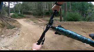
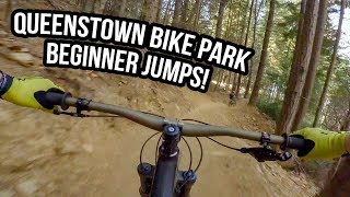
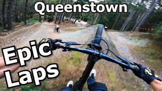
Custom built by Veritgo Bikes owner Tim Ceci in the mid 90's, specifically to run guided mountain biking trips before Gondola access opened. Around 1.5km long, it's a machine built trail with nice and wide but steeper and rougher terrain than Hammy's. Starting from the summit of the Gondola and stretching through to the mid-way clearing, it also features a lot of rollers and small jumps to build your skills.
source: Skyline Queenstown
Traditionally Indigenous Territory
More Stats for Vertigo mountain bike trail trail
-
Altitude change-606 ft
-
Altitude min1,935 ft
-
Altitude max2,540 ft
-
Altitude start2,540 ft
-
Altitude end1,935 ft
-
Grade-16.269%
-
Grade max-79.79%
-
Grade min24.266%
-
Distance climb169 ft
-
Distance down3,250 ft
-
Distance flat304 ft
-
Avg time00:03:51
-
Avg reverse time00:20:52
- view trail stats
close
3D
Trail Conditions
- Unknown
- Snow Groomed
- Snow Packed
- Snow Covered
- Snow Cover Inadequate
- Freeze/thaw Cycle
- Icy
- Prevalent Mud
- Wet
- Variable
- Ideal
- Dry
- Very Dry
Trail Flow (Ridden Direction)
Trailforks scans users ridelogs to determine the most popular direction each trail is ridden. A good flowing trail network will have most trails flowing in a single direction according to their intension.
The colour categories are based on what percentage of riders are riding a trail in its intended direction.
- > 96%
- > 90%
- > 80%
- > 70%
- > 50%
- < 50%
- bi-directional trail
- no data
Trail Last Ridden
Trailforks scans ridelogs to determine the last time a trail was ridden.
- < 2 days
- < 1 week
- < 2 weeks
- < 1 month
- < 6 months
- > 6 months
Trail Ridden Direction
The intended direction a trail should be ridden.
- Downhill Only
- Downhill Primary
- Both Directions
- Uphill Primary
- Uphill Only
- One Direction
Contribute Details
Colors indicate trail is missing specified detail.
- Description
- Photos
- Description & Photos
- Videos
Trail Popularity ?
Trailforks scans ridelogs to determine which trails are ridden the most in the last 9 months.
Trails are compared with nearby trails in the same city region with a possible 25 colour shades.
Think of this as a heatmap, more rides = more kinetic energy = warmer colors.
- most popular
- popular
- less popular
- not popular
ATV/ORV/OHV Filter
Max Vehicle Width
inches
Radar Time
x
Activity Recordings
Trailforks users anonymized public ridelogs from the past 6 months.
- mountain biking recent
- mountain biking (>6 month)
- hiking (1 year)
- moto (1 year)
Activity Recordings
Trailforks users anonymized public skilogs from the past 12 months.
- Downhill Ski
- Backcountry Ski
- Nordic Ski
- Snowmobile
Jump Magnitude Heatmap
Heatmap of where riders jump on trails. Zoom in to see individual jumps, click circles to view jump details.
Trails Deemphasized
Trails are shown in grey.
Only show trails with NO bikes.
Save the current map location and zoom level as your default home location whenever this page is loaded.
Save
Directions to vertigo trailhead
(-45.026630, 168.644900)
update trails status or condition
Vertigo Trail Reports
view all reports »
Recent Ridelog Activity on Trail
Past Week
- 32 rides
- 16 miles avg distance
6 Months
- 535 rides
- 18 miles avg distance
All
- 3,376 rides
- Last: Feb 9, 2023
Photos
more »
Videos
more »
Nearby Trails
- I'm A Shreddin 203 ft
- Beeched As 732 ft
- Thingymajig 735 ft
- Armageddon 902 ft
- Gary 942 ft
Queenstown Bike Park
- embed Vertigo trail on your website
- By nakinoah
& contributors
- #8275 - 3,943 views
- subscribe
- login to download gpx or kml files.