more stats
4,259 ft
Distance
21 ft
Climb
-337 ft
Descent
00:02:34
Avg time
-324 ft
Altitude change
9,485 ft
Altitude min
9,809 ft
Altitude max
9,809 ft
Altitude start
9,485 ft
Altitude end
-7.6%
Grade
-25%
Grade max
13.2%
Grade min
384 ft
Distance climb
3,360 ft
Distance down
515 ft
Distance flat
00:02:34
Avg time

Viking (Upper) Details

  • Activities
    • Mountain Bike
  • Riding Area
    Snowmass Bike Park
    Snowmass Village, Colorado
  • Difficulty Rating
  • Voted Difficulty
    Blue (1 vote)
  • Local Popularity
    100 in Mountain Biking
  • Global Ranking
    #40882 in Mountain Biking
  • Trail Type
    Singletrack
  • Direction
    Downhill Primary
    Popular Direction Shown
  • Climb Difficulty
    Blue
  • Physical Rating
    Moderate
  • Dogs Allowed
    Yes

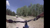
Viking is an intermediate jump trail. This upper section has some fun little table tops and big berms that cut through the trees. There is a nice little sender right before some big berms and then it drops you out on the newly cut section of Verde. Then you follow Verde to a big intersection in a meadow and decide where you want to continue.

Trail Supporters

  • USFS
    Land Manager

Bike Park

Traditionally Indigenous Territory

Recent Activity on Trail

Past Week
  • 20 rides
  • 24 miles average
6 Months
  • 36 rides
  • 24 miles avg distance
All
  • 367 rides
  • Last: Jul 3, 2026
c1c2c3c4
January
February
March
April
May
June
July
August
September
October
November
December
Status:
on Jul 3, 2026
Dry
Avg: 3.99 (9 votes)
Your vote: 0

view (3,196)
close
3D
Trail Conditions
  • Unknown
  • Snow Groomed
  • Snow Packed
  • Snow Covered
  • Snow Cover Partial
  • Freeze/thaw Cycle
  • Icy
  • Prevalent Mud
  • Wet
  • Variable
  • Ideal
  • Dry
  • Very Dry
Trail Flow (Ridden Direction)
Trailforks scans users ridelogs to determine the most popular direction each trail is ridden. A good flowing trail network will have most trails flowing in a single direction according to their intension.
The colour categories are based on what percentage of riders are riding a trail in its intended direction.
  • > 96%
  • > 90%
  • > 80%
  • > 70%
  • > 50%
  • < 50%
  • bi-directional trail
  • no data
Trail Last Ridden
Trailforks scans ridelogs to determine the last time a trail was ridden.
  • < 2 days
  • < 1 week
  • < 2 weeks
  • < 1 month
  • < 6 months
  • > 6 months
Trail Ridden Direction
The intended direction a trail should be ridden.
  • Downhill Only
  • Downhill Primary
  • Both Directions
  • Uphill Primary
  • Uphill Only
  • One Direction
Contribute Details
Colors indicate trail is missing specified detail.
  • Description
  • Photos
  • Description & Photos
  • Videos
Trail Popularity ?
Trailforks scans ridelogs to determine which trails are ridden the most in the last 9 months. Trails are compared with nearby trails in the same city region with a possible 25 colour shades. Think of this as a heatmap, more rides = more kinetic energy = warmer colors.
  • most popular
  • popular
  • less popular
  • not popular
ATV/ORV/OHV Filter
Max Vehicle Width
inches
US Cell Coverage
Legend
cell carrier legend

Radar Time
Activity Recordings
Trailforks uses anonymized public activity data. ?
Activity Recordings
Trailforks uses anonymized public activity data. ?
Personal Heatmap
Activity Types
all / none
Options
2
Date range month
Winter Trails
Warning A routing network for winter maps does not exist. Selecting trails using the winter trails layer has been disabled.
Missing Trails
Most Popular
Least Popular
Trails are colored based on popularity. The more popular a trail is, the more red. Less popular trails trend towards green.
Jump Magnitude Heatmap
Heatmap of where riders jump on trails. Zoom in to see individual jumps, click circles to view jump details.
BC Backroad Status

Service Road Atlas is a free to use, community-driven service for viewing and creating reports on the numerous back-country service roads around B.C. and Alberta.

map legend
Slope Aspect
Direction the slope faces
Flat N NE E SE S SW W NW
Trails Deemphasized
Trails are shown in grey.
disable
Only show trails with no bike usage.
Enable
Suggested Layers
Based on selected activity type

    Save the current map location and zoom level as your default home location whenever this page is loaded.

    Save
        Directions to viking-upper trailhead (39.189110, -106.935710)

        Photos

        1 more »
        94 |
        Aug 12, 2019 @ 7:16pm
        Aug 12, 2019

        Videos

        2 more »
        Front wheel Wash out
        0:19 | 73 | Aug 4, 2020 , Snowmass Village
        Dusty on the viking
        0:19 | 88 | Oct 15, 2009 , Snowmass Village

        Routes with this trail

        10 miles 1,876 ft 13 Loop
        I created this loop as a semi-epic after hours or Fall weekday ride to enable great XC training climb and...
        3.4 12 miles 802 ft 8 Shuttled
        33 miles 5,521 ft 35 Loop
        Trying to find a way to loop Snomwass and Governement.

        1 Review & Comments


        We hope you've been enjoying Trailforks!

        Create a FREE account to view trail comments and much more.

        • By toddTF Pro Trailforks & contributors
        • #27348 - 1,517 views

        Frequently Asked Questions About Viking (Upper)

        Where is Viking (Upper) located?
        Viking (Upper) is located in Snowmass Bike Park, Snowmass Village, Colorado, United States. It is part of the Snowmass Bike Park trail network. The trailhead is located at coordinates 39.18911, -106.93571.
        How hard is Viking (Upper)?
        Viking (Upper) is rated as Blue difficulty. The physical rating is Moderate. The average grade is 7.6%. The climb difficulty is rated Blue.
        What is the elevation gain for Viking (Upper)?
        Viking (Upper) has 21 ft of elevation gain. The trail has 337 ft of elevation descent. The elevation ranges from 9,485 ft to 9,809 ft.
        Is Viking (Upper) a point to point trail?
        Viking (Upper) is not a point to point trail. The direction is Downhill Primary. The trail type is singletrack.

        Hit the Trail

        Open in App

        Get this trail on your phone instantly.
        open trail in app

        Download Trail

        Save to wishlist, Garmin & download.
        save the trail

        Find Related Routes

        Find routes and users activities that include this trail.
        find routes for this trail

        You must enter a description before submitting.