

more stats
1,575 ft
Distance
-279 ft
Descent
00:04:36
Avg time
-279 ft
Altitude change
442 ft
Altitude min
721 ft
Altitude max
721 ft
Altitude start
443 ft
Altitude end
-17.7%
Grade
-42.6%
Grade max
-4.4%
Grade min
1,575 ft
Distance down
00:04:36
Avg time

Windfall Details

  • Activities
    • Mountain Bike
    • E-Bike
  • Riding Area
    Sportsman's
    Forks, Washington
  • Difficulty Rating
  • Local Popularity
    80 in Mountain Biking [+]
    • 80 in E-Biking
  • Global Ranking
    #7030 in Mountain Biking [+]
    • #42876 in E-Biking
  • State Ranking
    #172 in Mountain Biking · Washington [+]
    • #683 in E-Biking
  • Trail Type
    Singletrack
  • Bike Type
    DH, AM, XC
  • Direction
    Downhill Only
    Popular Direction Shown
  • Physical Rating
    Hard
  • Trail Visibility
    Always easy to follow
  • Season
    Year around
  • Dogs Allowed
    Yes
  • eBike Allowed
    Yes up to Class 1
  • Ride in Rain
    Yes
  • Year Opened
    2022
  • Land Owner
    DNR

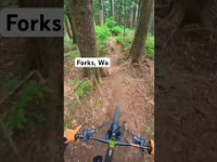
Purpose built proper enduro cut trail. Supposed turns near the bottom. Upper is middle speed and rest is slow speed tech. Trail uses raw flow to snake its way lovely coastal forest. Zones of this line are surrounded by a lot broken trees, as big winter storms rip through the area. Plush and green

Access Info

Use #3 Climb and/or Decent Track

Tags

Local Trail Association

Traditionally Indigenous Territory

Recent Activity on Trail

Past Week
  • 0 rides
  •  
6 Months
  • 5 rides
  • 10 miles avg distance
All
  • 13 rides
  • Last: Sep 21, 2026
update trails status or condition

Windfall Trail Reports

statusdatedescription
Mar 15, 2025 @ 7:32pm
Mar 15, 2025
reporter
Digging fresh turns
Oct 15, 2024 @ 2:51pm
Oct 15, 2024
reporter
Digging turns
Oct 9, 2024 @ 3:17pm
Oct 9, 2024
reporter
Digging on turns
Feb 4, 2024 @ 9:08am
Feb 4, 2024
reporter
Winter storm cleanup
Oct 14, 2023 @ 1:55pm
Oct 14, 2023
reporter
Cut roots, ruts, kickers and catch berms.
more »
Status:
on Mar 15, 2025
Ideal
Avg: 4.24 (2 votes)
Your vote: 0

view (29)
close
      Directions to windfall-504962 trailhead (47.938580, -124.368690)

      Photos

      4 more »
      mtb
      97 |
      May 23, 2022 @ 2:11pm
      May 23, 2022
      mtb
      89 |
      May 23, 2022 @ 2:11pm
      May 23, 2022
      mtb
      88 |
      May 23, 2022 @ 2:11pm
      May 23, 2022
      mtb
      88 |
      Mar 29, 2022 @ 5:26am
      Mar 29, 2022

      Videos

      2 more »
      Windfall Trail turns  #mtb
      mtb
      0:04 | 98 | May 14, 2025 , Forks
      Swerving trees in the forest #mtb
      mtb
      0:33 | 108 | Jul 25, 2023 , Forks

      Routes with this trail

      11 miles • 1,990 ft • 17 • Loop •
      Full suspension downhill capable eMTB trails. The less steep trails for the weight of an ebike. 4...
      8 miles • 2,306 ft • 20 •
      Forest flow, steeps and tech. True golden loam can be found here. All downhill segments on Strava.
      5.0 ★★★★★
      2 Ratings
      5 ★ 100%
      4 ★
      3 ★
      2 ★
      1 ★

      1 Review & Comments

      superdaveseattle superdaveseattle
      Thanks to Jake The Builder Windfall is in great shape. Traditional PNW Tech with plenty of spice. This trail is a great starter black.

      We hope you've been enjoying Trailforks!

      Create a FREE account to view all trail reviews and much more.

      • By ForksMTB2 FORKS & contributors
      • #504962 - 635 views

      Frequently Asked Questions

      ▼ Where is Windfall located?
      Windfall is located in Sportsman's, Forks, Washington, United States. It is part of the Sportsman's trail network. The trailhead is located at coordinates 47.93858, -124.36869.
      ▼ How hard is Windfall?
      Windfall is rated as Black Diamond difficulty. The physical rating is Hard. The average grade is 17.7%.
      ▼ What is the elevation gain for Windfall?
      The trail has 279 ft of elevation descent. The elevation ranges from 442 ft to 721 ft.
      ▼ Is Windfall a point to point trail?
      Yes, Windfall is a point to point trail. The direction is Downhill Only. The trail type is singletrack.
      ▼ How long is Windfall?
      Windfall is 1,575 ft long. The trail type is singletrack.
      ▼ Are dogs allowed on Windfall?
      Yes, dogs are allowed on Windfall. Please keep dogs on a leash where required and clean up after them.
      ▼ When is the best time of year to ride Windfall?
      Windfall is best visited during: Year around.
      ▼ How do I access Windfall? Where is the closest parking trailhead?
      The closest parking and trailhead locations to Windfall are: View all parking locations in the area.
      ▼ How long does it take to ride Windfall?
      Based on recorded activities, it takes an average of 5 minutes to ride Windfall. The trail is 1,575 ft long. Actual times will vary based on fitness level, conditions, and pace. View recent activity logs for more details.
      ▼ How busy is Windfall?
      Windfall is a very popular trail. There have been 27 recorded activities on this trail. The trail has received 29 check-ins. View recent activity on this trail.

      Hit the Trail

      Open in App

      Get this trail on your phone instantly.

      open trail in app

      Download Trail

      Save to wishlist, Garmin & download.
      save the trail

      Find Related Routes

      Find routes and users activities that include this trail.
      find routes for this trail

      You must enter a description before submitting.

