more stats
1.9 miles
Distance
550 ft
Climb
-1,626 ft
Descent
00:09:02
Avg time
-1,076 ft
Altitude change
1,414 ft
Altitude min
2,490 ft
Altitude max
2,490 ft
Altitude start
1,414 ft
Altitude end
-10.5%
Grade
-103.7%
Grade max
69%
Grade min
2,746 ft
Distance climb
1 mile
Distance down
1,545 ft
Distance flat
00:09:02
Avg time

Wingman Details

  • Activities
    • Mountain Bike
  • Riding Area
  • Ref Number
    #15
  • Difficulty Rating
  • Local Popularity
    60 in Mountain Biking
  • Global Ranking
    #32005 in Mountain Biking
  • Trail Type
    Machine Groomed
  • Bike Type
    DH
  • Direction
    Downhill Only
    Popular Direction Shown
  • Physical Rating
    Moderate
  • Dogs Allowed
    Yes
  • TTFs on Trail
    Berm, Bridge, Jump
  • Ride in Rain
    Yes

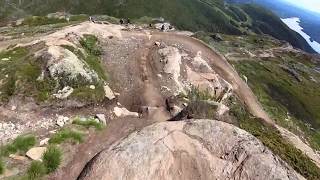
Åreskutans kanske mest omtalade led, och det av en god anledning. Den är en lång maskingrävd hoppled fullmatad med stora velodromkurvor och ett 50-tal, minst lika stora, hopp. En adrenalinfylld, skrattframkallande resa hela vägen ner till Stjärntorget.

Bike Park

Traditionally Indigenous Territory

Recent Activity on Trail

Past Week
  • 6 rides
  • 19.8 km average
6 Months
  • 11 rides
  • 38.1 km avg distance
All
  • 213 rides
  • Last: Jul 2, 2026
c1c2c3c4
January
February
March
April
May
June
July
August
September
October
November
December
Status:
on Jul 22, 2024
Variable
Avg: 4.46 (24 votes)
Your vote: 0

view (4,260)
close
3D
Trail Conditions
  • Unknown
  • Snow Groomed
  • Snow Packed
  • Snow Covered
  • Snow Cover Partial
  • Freeze/thaw Cycle
  • Icy
  • Prevalent Mud
  • Wet
  • Variable
  • Ideal
  • Dry
  • Very Dry
Trail Flow (Ridden Direction)
Trailforks scans users ridelogs to determine the most popular direction each trail is ridden. A good flowing trail network will have most trails flowing in a single direction according to their intension.
The colour categories are based on what percentage of riders are riding a trail in its intended direction.
  • > 96%
  • > 90%
  • > 80%
  • > 70%
  • > 50%
  • < 50%
  • bi-directional trail
  • no data
Trail Last Ridden
Trailforks scans ridelogs to determine the last time a trail was ridden.
  • < 2 days
  • < 1 week
  • < 2 weeks
  • < 1 month
  • < 6 months
  • > 6 months
Trail Ridden Direction
The intended direction a trail should be ridden.
  • Downhill Only
  • Downhill Primary
  • Both Directions
  • Uphill Primary
  • Uphill Only
  • One Direction
Contribute Details
Colors indicate trail is missing specified detail.
  • Description
  • Photos
  • Description & Photos
  • Videos
Trail Popularity ?
Trailforks scans ridelogs to determine which trails are ridden the most in the last 9 months. Trails are compared with nearby trails in the same city region with a possible 25 colour shades. Think of this as a heatmap, more rides = more kinetic energy = warmer colors.
  • most popular
  • popular
  • less popular
  • not popular
ATV/ORV/OHV Filter
Max Vehicle Width
inches
US Cell Coverage
Legend
cell carrier legend

Radar Time
Activity Recordings
Trailforks uses anonymized public activity data. ?
Activity Recordings
Trailforks uses anonymized public activity data. ?
Personal Heatmap
Activity Types
all / none
Options
2
Date range month
Winter Trails
Warning A routing network for winter maps does not exist. Selecting trails using the winter trails layer has been disabled.
Missing Trails
Most Popular
Least Popular
Trails are colored based on popularity. The more popular a trail is, the more red. Less popular trails trend towards green.
Jump Magnitude Heatmap
Heatmap of where riders jump on trails. Zoom in to see individual jumps, click circles to view jump details.
BC Backroad Status

Service Road Atlas is a free to use, community-driven service for viewing and creating reports on the numerous back-country service roads around B.C. and Alberta.

map legend
Slope Aspect
Direction the slope faces
Flat N NE E SE S SW W NW
Trails Deemphasized
Trails are shown in grey.
disable
Only show trails with no bike usage.
Enable
Suggested Layers
Based on selected activity type

    Save the current map location and zoom level as your default home location whenever this page is loaded.

    Save
        Directions to wingman trailhead (63.411630, 13.072370)

        Photos

        109 more »
        125 |
        Dec 30, 2022 @ 4:48am
        Dec 30, 2022
        199 |
        Sep 6, 2021 @ 8:16am
        Sep 6, 2021
        254 |
        Sep 6, 2021 @ 8:16am
        Sep 6, 2021
        317 |
        Sep 6, 2021 @ 8:16am
        Sep 6, 2021

        Videos

        22 more »
        Åre Bike Park - 15.  Shimano
        6:27 | 325 | Aug 3, 2021 , Åre
        Åre Bike Park - Svartberget, Shimano &...
        5:01 | 472 | Jul 21, 2019 , Åre
        Friday fail
        0:10 | 55 | Jul 26, 2024 , Åre
        7.July
        11:28 | 26 | Mar 1, 2021 , Åre

        1 Review & Comments


        We hope you've been enjoying Trailforks!

        Create a FREE account to view trail comments and much more.

        • By maciek1998TF Pro & contributors
        • #50244 - 4,935 views

        Frequently Asked Questions About Wingman

        Where is Wingman located?
        Wingman is located in Åre Bike Park, Åre, Sweden. It is part of the Åre Bike Park trail network. The trailhead is located at coordinates 63.41163, 13.07237.
        How hard is Wingman?
        Wingman is rated as Red difficulty. The physical rating is Moderate. The average grade is 10.5%.
        What is the elevation gain for Wingman?
        Wingman has 550 ft of elevation gain. The trail has 1,626 ft of elevation descent. The elevation ranges from 1,414 ft to 2,490 ft.
        Is Wingman a point to point trail?
        Yes, Wingman is a point to point trail. The direction is Downhill Only. The trail type is machine groomed.

        Hit the Trail

        Open in App

        Get this trail on your phone instantly.
        open trail in app

        Download Trail

        Save to wishlist, Garmin & download.
        save the trail

        Find Related Routes

        Find routes and users activities that include this trail.
        find routes for this trail

        You must enter a description before submitting.