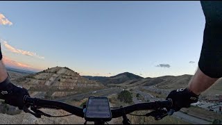


more stats
1.3 miles
Distance
141 ft
Climb
-420 ft
Descent
00:12:00
Avg time
-279 ft
Altitude change
6,114 ft
Altitude min
6,524 ft
Altitude max
6,393 ft
Altitude start
6,115 ft
Altitude end
-4%
Grade
-36.9%
Grade max
22.3%
Grade min
2,346 ft
Distance climb
4,383 ft
Distance down
164 ft
Distance flat
00:12:00
Avg time

Wrigley's Details

  • Activities
    • Mountain Bike
    • E-Bike
    • Horse
    • Hike
    • Trail Running
  • Riding Area
    Green Mountain
    Lakewood, Colorado
  • Difficulty Rating
  • Voted Difficulty
    Black Diamond (2 votes)
  • Local Popularity
    65 in Mountain Biking heatmap [+]
    • 55 in E-Biking
    • 50 in Trail Running
    • 70 in Hiking
    • 5 in Horseback
  • Global Ranking
    #94029 in Mountain Biking [+]
    • #124048 in E-Biking
    • #146674 in Trail Running
    • #124639 in Hiking
    • #4121 in Horseback
  • State Ranking
    #1,855 in Mountain Biking · Colorado [+]
    • #1,237 in E-Biking
    • #4,339 in Trail Running
    • #3,589 in Hiking
    • #79 in Horseback
  • Trail Type
    Singletrack
  • Direction
    Both Directions
    Popular Direction Shown
  • Dogs Allowed
    Yes
  • eBike Allowed
    Yes up to Class 1

No community description for Wrigley's trail has been added yet!

AI Generated Description

Wrigley's is a highly rated 1 mile moderately popular blue difficulty singletrack trail located near Lakewood Colorado. This multi-use trail can be used both directions. On average it takes 12 minutes to complete this trail.

Tags

Local Trail Association

Traditionally Indigenous Territory

Recent Activity on Trail

Past Week
  • 0 rides
  •  
6 Months
  • 1 rides
  • 10 miles avg distance
All
  • 39 rides
  • Last: Nov 14, 2026
c1c2c3c4
January
February
March
April
May
June
July
August
September
October
November
December
update trails status or condition

Wrigley's Trail Reports

statusdatedescription
Apr 7, 2021 @ 10:07am
Apr 7, 2021
Wrigley's was perfect. Almost hero dirt.
Apr 29, 2020 @ 8:39pm
Apr 29, 2020
Jan 23, 2020 @ 9:28pm
Jan 23, 2020
G2G
Jan 14, 2020 @ 5:34pm
Jan 14, 2020
Some ice on the north end, but worth riding.
Dec 19, 2019 @ 9:23pm
Dec 19, 2019
The north end has long icy sections - thin so they may melt soon. The middle and southern end are clear.
more »
Status:
on Apr 7, 2021
Ideal
Avg: 4.16 (6 votes)
Your vote: 0

view (631)
close
      Directions to wrigley-s trailhead (39.701810, -105.203560)

      Photos

      2 more »
      mtb
      186 |
      Sep 17, 2024 @ 6:56pm
      Sep 17, 2024
      mtb
      167 |
      Sep 17, 2024 @ 6:56pm
      Sep 17, 2024

      Videos

      1 more »
      Wrigley's - ridgeline blue tech high above...
      mtb
      14:11 | 196 | Sep 19, 2024 , Lakewood

      Routes with this trail

      more »
      23 miles • 3,854 ft • 35 •
      Front Range Chimney Gulch, Enchanted Forest, Green Mountain loop
      4.4 ★★★★★
      6 Ratings
      5 ★ 50%
      4 ★ 33%
      3 ★ 17%
      2 ★
      1 ★

      7 Reviews & Comments

      tsandman
      Super overgrown, not worth. Just ride Dakota
      Kdub91712 Kdub91712
      First time on this one and the “open mine shafts & beware of rattlesnakes” signs made me a bit more cautious . Bit of intense exposure on the south end as well. Some cool views though, especially at sunset. Similar vibes to nearby Dakota ridge but not nearly as technical/difficult.

      If riding north make sure to take the left at the fork after the power line tower, as the right section seems more hiker friendly and I also saw some glass when I attempted that route.
      chuyler1 chuyler1
      While staying at the Dakota Ridge RV Park (not recommended -- loud motorcycle bar next door) I used this to access other trails and rode it in both directions. Heading south on the trail, it is a steep but mostly clearable climb. Heading north on the trail back to the RV park the trail is much more enjoyable. The initial climb is very tame in this direction, wide but covered in loose rock, and the descent has only one or two technical sections to worry about and no drops, gaps, or extended rock gardens. If you only ride it in one direction, northward is the way to do it.

      We hope you've been enjoying Trailforks!

      Create a FREE account to view all trail reviews and much more.

      • By toddTF Pro Trailforks & contributors
      • #51546 - 3,575 views

      Frequently Asked Questions

      ▼ Where is Wrigley's located?
      Wrigley's is located in Green Mountain, Lakewood, Colorado, United States. It is part of the Green Mountain trail network. The trailhead is located at coordinates 39.70181, -105.20356.
      ▼ How hard is Wrigley's?
      Wrigley's is rated as Blue difficulty. The average grade is 4%.
      ▼ What is the elevation gain for Wrigley's?
      Wrigley's has 141 ft of elevation gain. The trail has 420 ft of elevation descent. The elevation ranges from 6,114 ft to 6,524 ft.
      ▼ Is Wrigley's a point to point trail?
      Wrigley's is not a point to point trail. The direction is Both Directions. The trail type is singletrack.
      ▼ How long is Wrigley's?
      Wrigley's is 1.3 miles long. The trail type is singletrack.
      ▼ Are dogs allowed on Wrigley's?
      Yes, dogs are allowed on Wrigley's. Please keep dogs on a leash where required and clean up after them.
      ▼ When is the best time of year to ride Wrigley's?
      Based on activity log data, the most popular months to ride Wrigley's are:
      • April (3 activities)
      • August (3 activities)
      • July (2 activities)
      Check the reports page for current trail conditions.
      ▼ How do I access Wrigley's? Where is the closest parking trailhead?
      The closest parking and trailhead locations to Wrigley's are: View all parking locations in the area.
      ▼ How long does it take to ride Wrigley's?
      Based on recorded activities, it takes an average of 12 minutes to ride Wrigley's. The trail is 1.3 miles long. Actual times will vary based on fitness level, conditions, and pace. View recent activity logs for more details.
      ▼ How busy is Wrigley's?
      Wrigley's is a moderately popular trail. There have been 644 recorded activities on this trail. The trail has received 631 check-ins. View recent activity on this trail.

      Hit the Trail

      Open in App

      Get this trail on your phone instantly.

      open trail in app

      Download Trail

      Save to wishlist, Garmin & download.
      save the trail

      Find Related Routes

      Find routes and users activities that include this trail.
      find routes for this trail

      You must enter a description before submitting.