This trail is permanently closed/decommissioned
more stats
2,231 ft
Distance
-189 ft
Descent
00:02:45
Avg time
-189 ft
Altitude change
2,995 ft
Altitude min
3,185 ft
Altitude max
3,185 ft
Altitude start
2,995 ft
Altitude end
-8.5%
Grade
-22.9%
Grade max
2,169 ft
Distance down
00:02:45
Avg time

Yaba Details

  • Activities
    • Mountain Bike
    • E-Bike
  • Riding Area
  • Difficulty Rating
  • Local Popularity
    70 in Mountain Biking [+]
    • 5 in E-Biking
  • Trail Type
    Singletrack
  • Bike Type
    AM, XC, DJ
  • Trail Visibility
    Always easy to follow
  • eBike Allowed
    Yes up to Class 1
  • TTFs on Trail
    Berm, Drop, Jump, Gap Jump

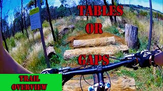
Jump track. Lots of options for learning to jump. It is mostly rollable (except the first small skill check jump) with harder options and optional gap jumps. However, it's easy to build up speed and get in the air higher than you are prepared for. Take it easy and scope out the track before letting loose.

Access Info

Turns off Dinosaur Breakout just below the highest point. Look for the steel arch with the sign above the trail.

Local Trail Association
Traditionally Indigenous Territory

Recent Activity on Trail

Past Week
  • 0 rides
  •  
6 Months
  • 0 rides
  •  
All
  • 42 rides
  • Last: Dec 27, 2025
c1c2c3c4
January
February
March
April
May
June
July
August
September
October
November
December
update trails status or condition

Yaba Trail Reports

statusdatedescription
Jul 13, 2025 @ 4:57am
Jul 13, 2025
reporter
CLOSED Trail has been closed due to low use and to reduce maintenance requirements for the Orange Mountain Bike Club. Please visit Glenwood...
Apr 3, 2025 @ 6:16pm
Apr 3, 2025
Top half is overgrown. Middle is severely damaged and most gap jumps are overgrown. Bottom is overgrown and damaged. Better off riding the other...
Jan 31, 2025 @ 2:44pm
Jan 31, 2025
Feb 9, 2024 @ 9:20am
Feb 9, 2024
Pretty overgrown and unloved these days
May 5, 2023 @ 6:56pm
May 5, 2023
very wet in places and lots of mud
more »
Status:
on Jul 13, 2025
Avg: 4.09 (4 votes)
Your vote: 0

view (759)
close
3D
Trail Conditions
  • Unknown
  • Snow Groomed
  • Snow Packed
  • Snow Covered
  • Snow Cover Partial
  • Freeze/thaw Cycle
  • Icy
  • Prevalent Mud
  • Wet
  • Variable
  • Ideal
  • Dry
  • Very Dry
Trail Flow (Ridden Direction)
Trailforks scans users ridelogs to determine the most popular direction each trail is ridden. A good flowing trail network will have most trails flowing in a single direction according to their intension.
The colour categories are based on what percentage of riders are riding a trail in its intended direction.
  • > 96%
  • > 90%
  • > 80%
  • > 70%
  • > 50%
  • < 50%
  • bi-directional trail
  • no data
Trail Last Ridden
Trailforks scans ridelogs to determine the last time a trail was ridden.
  • < 2 days
  • < 1 week
  • < 2 weeks
  • < 1 month
  • < 6 months
  • > 6 months
Trail Ridden Direction
The intended direction a trail should be ridden.
  • Downhill Only
  • Downhill Primary
  • Both Directions
  • Uphill Primary
  • Uphill Only
  • One Direction
Contribute Details
Colors indicate trail is missing specified detail.
  • Description
  • Photos
  • Description & Photos
  • Videos
Trail Popularity ?
Trailforks scans ridelogs to determine which trails are ridden the most in the last 9 months. Trails are compared with nearby trails in the same city region with a possible 25 colour shades. Think of this as a heatmap, more rides = more kinetic energy = warmer colors.
  • most popular
  • popular
  • less popular
  • not popular
ATV/ORV/OHV Filter
Max Vehicle Width
inches
US Cell Coverage
Legend
cell carrier legend

Radar Time
Activity Recordings
Trailforks uses anonymized public activity data. ?
Activity Recordings
Trailforks uses anonymized public activity data. ?
Personal Heatmap
Activity Types
all / none
Options
2
Date range month
Winter Trails
Warning A routing network for winter maps does not exist. Selecting trails using the winter trails layer has been disabled.
Missing Trails
Most Popular
Least Popular
Trails are colored based on popularity. The more popular a trail is, the more red. Less popular trails trend towards green.
Jump Magnitude Heatmap
Heatmap of where riders jump on trails. Zoom in to see individual jumps, click circles to view jump details.
BC Backroad Status

Service Road Atlas is a free to use, community-driven service for viewing and creating reports on the numerous back-country service roads around B.C. and Alberta.

map legend
Slope Aspect
Direction the slope faces
Flat N NE E SE S SW W NW
Trails Deemphasized
Trails are shown in grey.
disable
Only show trails with no bike usage.
Enable
Suggested Layers
Based on selected activity type

    Save the current map location and zoom level as your default home location whenever this page is loaded.

    Save
        Directions to yaba trailhead (-33.308550, 149.021020)

        Photos

        8 more »
        47 |
        May 5, 2023 @ 6:57pm
        May 5, 2023
        210 |
        Jun 28, 2020 @ 5:28pm
        Jun 28, 2020
        211 |
        Apr 2, 2020 @ 10:28pm
        Apr 2, 2020
        248 |
        Feb 2, 2019 @ 5:52am
        Feb 2, 2019

        Videos

        1 more »
        Lake Canobolas MTB Park (Yabba) 'Black Diamond'
        4:32 | 1255 | May 31, 2021 , Orange

        4 Reviews & Comments


        We hope you've been enjoying Trailforks!

        Create a FREE account to view trail comments and much more.

        • By G-DawggTF Pro OMC & contributors
        • #166352 - 2,073 views

        Frequently Asked Questions About Yaba

        Where is Yaba located?
        Yaba is located in Lake Canobolas Mountain Bike Park, Orange, Australia. It is part of the Lake Canobolas Mountain Bike Park trail network. The trailhead is located at coordinates -33.30855, 149.02102.
        How hard is Yaba?
        Yaba is rated as Black Diamond difficulty. The average grade is 8.5%.
        What is the elevation gain for Yaba?
        The trail has 189 ft of elevation descent. The elevation ranges from 2,995 ft to 3,185 ft.
        How long is Yaba?
        Yaba is 2,231 ft long. The trail type is singletrack.

        Hit the Trail

        Open in App

        Get this trail on your phone instantly.
        open trail in app

        Download Trail

        Save to wishlist, Garmin & download.
        save the trail

        Find Related Routes

        Find routes and users activities that include this trail.
        find routes for this trail

        You must enter a description before submitting.