
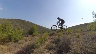
more stats
951 ft
Distance
-49 ft
Descent
00:01:20
Avg time
-49 ft
Altitude change
1,338 ft
Altitude min
1,388 ft
Altitude max
1,388 ft
Altitude start
1,339 ft
Altitude end
-5.2%
Grade
-24.4%
Grade max
3.8%
Grade min
82 ft
Distance climb
492 ft
Distance down
289 ft
Distance flat
00:01:20
Avg time

Zagalakata Details

  • Activities
    • Mountain Bike
    • Hike
    • Trail Running
  • Riding Area
  • Difficulty Rating
  • Global Ranking
    #138976 in Mountain Biking [+]
    • #369034 in Trail Running
    • #360689 in Hiking
  • National Ranking
    #758 in Mountain Biking · Greece [+]
    • #977 in Trail Running
    • #853 in Hiking
  • Trail Type
    Singletrack
  • Bike Type
    AM
  • Direction
    Downhill Only
  • Dogs Allowed
    Yes

Small trail.
Respect the work done from people before you. Be thankful that you are here. You know the rule :No dig no ride. Ask how you can help in service sessions. Don’t start working by yourself.
Do not alter features without permission, maybe you don’t have the skills, maybe you have better skills, maybe you have seen something else somewhere else and you would like it here, it doesn’t matter, the features are here for a reason and for all skills levels. Don’t create shortcuts, strava sucks. Don’t litter the place, take your garbage back with you. Braking skidding is not roosting, improve your skills, no braking on berms, no braking after jumps, do not create unnecessary damage.
100s of people know about this, but keep it quiet, don’t post gps locations and videos online, you are visitor respect that.Respect the nature,
Respect and protect walkers, families, children. Respect the neighbouring houses, don’t make stupid noises, especially in late hours.Do not ride the trail in the opposite direction. You can get hurt or hurt somebody else that is coming down.
No moto, trail is small, is not fun for moto, and motos destroy the work done .
Avoid wet days as it creates a lot of damage.Do not occupy sections of the trail (eg for sessioning one jump) when others are riding at the same time, Say hello to each other, make friends, enjoy

Tags
Family friendlyJumps

Local Trail Association

Recent Activity on Trail

Past Week
  • 0 rides
  •  
6 Months
  • 0 rides
  •  
All
  • 21 rides
  • Last: Feb 5, 2026
c1c2c3c4
January
February
March
April
May
June
July
August
September
October
November
December
update trails status or condition

Zagalakata Trail Reports

statusdatedescription
Dec 27, 2021 @ 4:10am
Dec 27, 2021
more »
Status:
on Dec 27, 2021
Ideal
Avg: 4.13 (1 votes)
Your vote: 0

view (38)
close
      Directions to zagalakata trailhead (38.040900, 23.887370)

      Photos

      3 more »
      mtb
      35 |
      Jun 17, 2023 @ 6:59am
      Jun 17, 2023
      mtb
      94 |
      Jan 6, 2021 @ 9:33am
      Jan 6, 2021
      mtb
      120 |
      Jan 6, 2021 @ 9:04am
      Jan 6, 2021

      Videos

      1 more »
      phone clips
      mtb
      0:23 | 125 | May 6, 2023 , marousi
      5.0 ★★★★★
      1 Ratings
      5 ★ 100%
      4 ★
      3 ★
      2 ★
      1 ★

      1 Review & Comments

      perigeo perigeo
      Πολύ καλο με πολύ ωραία αλματακια ...


      Είναι πολύ μικρό και απότομο

      We hope you've been enjoying Trailforks!

      Create a FREE account to view all trail reviews and much more.

      • By dimitrisz & contributors
      • #230842 - 891 views

      Frequently Asked Questions

      ▼ Where is Zagalakata located?
      Zagalakata is located in Penteli Mountain, marousi, Greece. It is part of the Penteli Mountain trail network. The trailhead is located at coordinates 38.0409, 23.88737.
      ▼ How hard is Zagalakata?
      Zagalakata is rated as Blue difficulty. The average grade is 5.2%.
      ▼ What is the elevation gain for Zagalakata?
      The trail has 49 ft of elevation descent. The elevation ranges from 1,338 ft to 1,388 ft.
      ▼ Is Zagalakata a point to point trail?
      Yes, Zagalakata is a point to point trail. The direction is Downhill Only. The trail type is singletrack.
      ▼ How long is Zagalakata?
      Zagalakata is 951 ft long. The trail type is singletrack.
      ▼ Are dogs allowed on Zagalakata?
      Yes, dogs are allowed on Zagalakata. Please keep dogs on a leash where required and clean up after them.
      ▼ When is the best time of year to ride Zagalakata?
      Based on activity log data, the most popular months to ride Zagalakata are:
      • November (4 activities)
      • June (2 activities)
      • July (2 activities)
      Check the reports page for current trail conditions.
      ▼ How do I access Zagalakata? Where is the closest parking trailhead?
      The closest parking and trailhead locations to Zagalakata are: View all parking locations in the area.
      ▼ How long does it take to ride Zagalakata?
      Based on recorded activities, it takes an average of 1 minute to ride Zagalakata. The trail is 951 ft long. Actual times will vary based on fitness level, conditions, and pace. View recent activity logs for more details.
      ▼ How busy is Zagalakata?
      Zagalakata is a less popular trail with lighter traffic. There have been 263 recorded activities on this trail. The trail has received 38 check-ins. View recent activity on this trail.

      Hit the Trail

      Open in App

      Get this trail on your phone instantly.

      open trail in app

      Download Trail

      Save to wishlist, Garmin & download.
      save the trail

      Find Related Routes

      Find routes and users activities that include this trail.
      find routes for this trail

      You must enter a description before submitting.

