close
-
Layers w
- Weather Layers
- Pro
- Pro
- Pro
- Pro
- Pro
- Pro
- More Layers
- Pro
- Pro
- Pro
- Pro
-
Upgrade to

3D
Trail Conditions
- Unknown
- Snow Groomed
- Snow Packed
- Snow Covered
- Snow Cover Partial
- Freeze/thaw Cycle
- Icy
- Prevalent Mud
- Wet
- Variable
- Ideal
- Dry
- Very Dry
Trail Flow (Ridden Direction)
Trailforks scans users ridelogs to determine the most popular direction each trail is ridden. A good flowing trail network will have most trails flowing in a single direction according to their intension.
The colour categories are based on what percentage of riders are riding a trail in its intended direction.
The colour categories are based on what percentage of riders are riding a trail in its intended direction.
- > 96%
- > 90%
- > 80%
- > 70%
- > 50%
- < 50%
- bi-directional trail
- no data
Trail Last Ridden
Trailforks scans ridelogs to determine the last time a trail was ridden.
- < 2 days
- < 1 week
- < 2 weeks
- < 1 month
- < 6 months
- > 6 months
Trail Ridden Direction
The intended direction a trail should be ridden.
- Downhill Only
- Downhill Primary
- Both Directions
- Uphill Primary
- Uphill Only
- One Direction
Contribute Details
Colors indicate trail is missing specified detail.
- Description
- Photos
- Description & Photos
- Videos
Trail Popularity ?
Trailforks scans ridelogs to determine which trails are ridden the most in the last 9 months.
Trails are compared with nearby trails in the same city region with a possible 25 colour shades.
Think of this as a heatmap, more rides = more kinetic energy = warmer colors.
- most popular
- popular
- less popular
- not popular
ATV/ORV/OHV Filter
Max Vehicle Width
inches
US Cell Coverage
Legend

Radar Time
Activity Recordings
Trailforks uses anonymized public activity data.
?
Activity Recordings
Trailforks uses anonymized public activity data.
?
Personal Heatmap
▶
Activity Types
all
/
none
▶
Options
2
Date range
month
–
Winter Trails
Warning
A routing network for winter maps does not exist. Selecting trails using the winter trails layer has been disabled.
Missing Trails
Most Popular
Least Popular
Trails are colored based on popularity. The more popular a trail is, the more red. Less popular trails trend towards green.
Jump Magnitude Heatmap
Heatmap of where riders jump on trails. Zoom in to see individual jumps, click circles to view jump details.
BC Backroad Status
![map legend]()
Service Road Atlas is a free to use, community-driven service for viewing and creating reports on the numerous back-country service roads around B.C. and Alberta.

Slope Aspect
Direction the slope faces
Trails Deemphasized
Trails are shown in grey.
Only show trails with no bike usage.
Suggested Layers
Based on selected activity type
Save the current map location and zoom level as your default home location whenever this page is loaded.
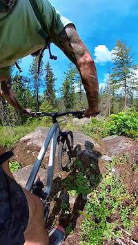
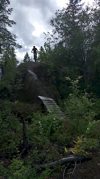
SaveRossland has a long history of mountain biking and is acclaimed as one of North America's top mountain biking destinations. In fact, it has acquired the reputation as 'The mountain biking capital of Canada', with its enormous variety of specialty built trails, from swooping, buffed singletrack to rock-armored, free-ride lines, to the 36 km, Seven Summits epic, there is the perfect ride for all types and abilities. Some of our favorite rides involve combining multiple shorter trails into a blissful circuit, while others, such as the historic Dewdney, or Whiskey trails take a single classic line.
Rossland also hosts a wealth of winter trails, including over 45 km of expertly groomed trails in the Black Jack XC Ski Club network, as well as a variety of ungroomed trails and an abundance of backcountry day-use cabins in the Rossland Range Recreation Site.
Rossland also hosts a wealth of winter trails, including over 45 km of expertly groomed trails in the Black Jack XC Ski Club network, as well as a variety of ungroomed trails and an abundance of backcountry day-use cabins in the Rossland Range Recreation Site.
Links
Activities Click to view
- Mountain Bike
173 trails
- E-Bike
165 trails
- Gravel Bike
51 trails
- Adaptive Bike
34 trails
- Winter Fat Bike
39 trails
- Horse
8 trails
- Hike
162 trails
- Trail Running
163 trails
- Snowshoe
20 trails
- Downhill Ski
98 trails
- Backcountry Ski
11 trails
- Nordic Ski
72 trails
Region Details
- 29
- 5
- 32
- 65
- 32
- 10
Region Status
Caution as of 8 hoursStats
- Avg Trail Rating
- Trails (view details)
- 350
- Trails Mountain Bike
- 173
- Trails E-Bike
- 165
- Trails Gravel Bike
- 51
- Trails Adaptive Bike
- 34
- Trails Winter Fat Bike
- 39
- Trails Horse
- 8
- Trails Hike
- 162
- Trails Trail Running
- 163
- Trails Dirtbike/Moto
- 3
- Trails ATV/ORV/OHV
- 3
- Trails Snowshoe
- 20
- Trails Downhill Ski
- 98
- Trails Backcountry Ski
- 11
- Trails Nordic Ski
- 72
- Total Distance
- 318 miles
- Total Descent
- 109,095 ft
- Total Vertical
- 5,679 ft
- Highest Trailhead
- 7,780 ft
- Reports
- 4,965
- Photos
- 1,573
- Ridden Counter
- 111,767
Articles

Video: Trail Building in British Columbia's Kootenay Mountains
May 15, 2022 from pinkbike.com
A series of short films featuring the work done by trail builders in the Kootenay region of British Columbia.

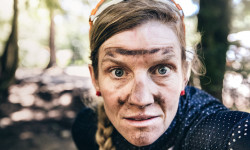
Downtime: Singletrack 6, 2016 - Photo Epic
Aug 10, 2016 from pinkbike.com
Having recovered from her first stage race experience at Singletrack 6 in the East Kootenays, Robin O’Neill shares some images she captured...
Singletrack 6's Portraits from the Back of the Pack
Nov 29, 2017 from pinkbike.com
Going into its fifth year in 2018, Singletrack 6 is starting to attract riders from all around the world. But they’re not the racers you’d...
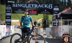
Race Report: The 2018 Singletrack 6
Aug 6, 2018 from pinkbike.com
With 6 days of epic cross-country racing, the Singletrack Six heads across choice locations in British Columbia.
Sub Regions
-
Downtown Rossland
- 1
- 9
- 4
-
Malde Creek
- 1
- 11
- 4
- 4
-
Monte Christo - KC
- 7
- 25
- 11
- 4
-
Neptune Creek
- 1
- 2
- 3
- 2
-
Red Mountain Community Trails
- 2
- 8
- 2
-
Red Mountain Resort Bike Park
- 1
- 3
- 7
- 4
- 1
-
Redstone
- 1
- 6
- 4
- 2
-
Rossland Range
- 1
- 2
- 1
- 6
Popular Rossland Mountain Biking Trails
• 80 ★ 4.5 • 4 miles • 0 ft • 1,722 •
The trail was originally built nearly 150 years ago, and although the current route utilizes only small sections of the original prospector route, the historic character of the trail is difficult to escape. Today, the KCTS maintains and...
• 75 ★ 4.4 • 18 miles • 3,585 ft • 1,605 •
The trail, completed in the summer of 2004 by the Kootenay Columbia Trails Society (KCTS), is a spectacular point to point single-track traverse of the Rossland Range. Widely acclaimed by mountain bikers, acknowledged by the...
• 90 ★ 4.7 • 1 mile • 13 ft • 1,348 •
The trail has seen many changes over the years, and in it’s current incarnation exhibits a mixed personality. is a Rossland classic and is a very popular trail within the network and certainly the most popular in the Malde Creek area....
• 90 ★ 4.6 • 2 miles • 33 ft • 1,278 •
A local favorite, and for good reason. The words fast and flowy may be overused but certainly would't be out of place for this gem. The trail is very buff, manicured, and has many options for all levels of riders including swoopy...
• 100 ★ 4.4 • 3,805 ft • 9 ft • 1,270 •
One of the funnest trails around. Fast and twisty trail through a wide range of sub-ecosystems. Some small wooden booters thrown in for good measure. Not recommended as an uphill.
• 100 ★ 4.6 • 5,259 ft • 142 ft • 1,222 •
A great two-way beginner to intermediate single track trail connecting from across to the bottom of . One of the few "flat" or lower angle trails on the Rossland trail menu. This is the perfect trail for bikers to work on their...
• 95 ★ 4.5 • 2 miles • 273 ft • 1,203 •
is a good little cross country trail that ovides a variety of different riding including some natural technical features such as rocks and roots (as should be expected in the nature) while still oviding a variety of line options to...
Rossland Mountain Bike Routes
★ 4.7 • 5 miles • 1,054 ft • 8 • Loop •
begins the loop, starting from Highway 3B, 12 km north of Rossland. The first 2.4 km, is great x-country...
★ 4.0 • 22 miles • 3,914 ft • 5 • Shuttled •
The trail followed by .
★ 5.0 • 38 miles • 7,280 ft • 28 • Loop •
A long ride, almost all singletrack. Redtop up and down, Caldera, Eddie J, lower Mongoose, KC, Techno...
★ 5.0 • 25 miles • 4,668 ft • 20 • Loop •
The best route if you want to pedal SMDA and Crown Point in one long ride. Whiskey on the Rocks optional,...
★ 3.5 • 6 miles • 1,111 ft • 14 • Loop •
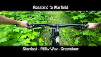
Park at the Centennial trailhead; ride up ; down ; down ; down Milky Way; then up Green Door / Roger's / /...
★ 4.0 • 6 miles • 1,421 ft • 11 • Loop •
Park at the head; ride up KC; down and Milky Way; up Green Door to Roger's; down/up Roger's; down ; and up...
Photos of Rossland Mountain Bike
Videos of Rossland Mountain Bike
trail: Upper Old Glory Trail
3:52 |
35 |
Oct 12, 2023
trail: Snake
0:06 |
56 |
Jun 30, 2023
trail: Yellow Submarine
0:52 |
326 |
Jun 30, 2023
trail: Pilgrim (upper)
0:26 |
72 |
Jul 4, 2022
trail: Whiskey on the Rocks
0:12 |
129 |
May 12, 2020
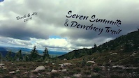
trail: Seven Summits
11:23 |
266 |
Apr 6, 2020
trail: Milky Way (lower)
11:29 |
134 |
Apr 5, 2020
trail: Redhead
3:31 |
421 |
Apr 4, 2020
Current Trail Warnings
| status | trail | date | condition | user | info |
|---|---|---|---|---|---|
| Milky Way (upper) | Jun 16, 2026 @ 11:04am (America/Vancouver) 13 hours | Unknown | M71ChT | Large tree down across the newer upper... | |
| Louie Joe (upper) | Jun 2, 2026 @ 4:28pm (America/Vancouver) Jun 2, 2026 | Dry | johnpeachell | Large tree down near Redstone end | |
| Lapis Dragon Tail Connector | May 26, 2026 @ 2:06pm (America/Vancouver) May 26, 2026 | Unknown | timeh69 RED | While we work on getting the Bike Park... |
Recent Trail Reports
| status | trail | date | condition | info | user |
|---|---|---|---|---|---|
| Cemetery (lower) | Jun 16, 2026 @ 4:40pm (America/Vancouver) 8 hours | Ideal | stewspooner KCTS | ||
| Blue Elephant | Jun 16, 2026 @ 4:39pm (America/Vancouver) 8 hours | Ideal | stewspooner KCTS | ||
| Whiskey on the Rocks | Jun 16, 2026 @ 4:38pm (America/Vancouver) 8 hours | Ideal | stewspooner KCTS | ||
| Stardust | Jun 16, 2026 @ 4:37pm (America/Vancouver) 8 hours | Ideal | stewspooner KCTS | ||
| Seven Summits | Jun 14, 2026 @ 7:56am (America/Vancouver) 3 days | Ideal | freerideposer KCTS | ||
| North Star | Jun 13, 2026 @ 1:03pm (America/Vancouver) Jun 13, 2026 | Unknown | mdant2476 | ||
| BS | Jun 12, 2026 @ 5:16pm (America/Vancouver) Jun 12, 2026 | Ideal | stewspooner KCTS | ||
| Doukhobor | Jun 12, 2026 @ 6:20am (America/Vancouver) Jun 12, 2026 | Ideal | stewspooner KCTS | ||
| Plewman Trail | Jun 12, 2026 @ 6:18am (America/Vancouver) Jun 12, 2026 | Ideal | stewspooner KCTS | ||
| Monticola | Jun 8, 2026 @ 2:31pm (America/Vancouver) Jun 8, 2026 | Ideal | Cooker1 |
Activity Feed
| username | action | type | title | date |
|---|---|---|---|---|
| stewspooner | add | report | activity #97146332 | Jun 16, 2026 @ 4:41pm 8 hours |
| stewspooner | add | report | activity #97146158 | Jun 16, 2026 @ 4:39pm 8 hours |
| stewspooner | add | report | activity #97146094 and 1 more | Jun 16, 2026 @ 4:38pm 8 hours |
| stewspooner | add | report | activity #97146003 | Jun 16, 2026 @ 4:37pm 8 hours |
| M71ChT | add | report | activity #97124352 | Jun 16, 2026 @ 11:04am 13 hours |
Recent Comments
| username | type | title | comment | date |
|---|---|---|---|---|
| trail | Trees still down | Jun 15, 2026 @ 2:31pm 1 day | ||
| report | Yes. Given this report, there will not be a... | Jun 13, 2026 @ 6:44am Jun 13, 2026 | ||
| report | How far up did you get? | Jun 12, 2026 @ 4:00pm Jun 12, 2026 | ||
| report | I saw a lot of mtb tire tracks up to just... | Jun 11, 2026 @ 4:51pm Jun 11, 2026 | ||
| report | That’s pretty high up. Best guess do you... | Jun 10, 2026 @ 6:54am Jun 10, 2026 |
Local Badges
-

Top 10 Trails88 awarded -

Big Ride 30k2,192 awarded -

Epic Ride 50k317 awarded -

10 Expert Trails43 awarded -

Completionist0 awarded -
Completionist0 awarded
Bike & Skill Parks
| name | type | city | rating |
|---|---|---|---|
| Red Mountain Resort Bike Park | bike park | Rossland | |
| Centennial Dirt Jumps | skill park | Rossland | |
| Rossglen Skills Park | skill park | Rossland |
Local Trail Supporters
- City of Rossland
- KCTS
Activity Type Stats
| activitytype | trails | distance | descent | descent distance | total vertical | rating | global rank | state rank | photos | reports | routes | ridelogs |
|---|---|---|---|---|---|---|---|---|---|---|---|---|
| Mountain Bike | 173 | 189 miles | 50,781 ft | 93 miles | 5,679 ft | #182 | #23 | 1,462 | 4,933 | 67 | 54,052 | |
| E-Bike | 165 | 175 miles | 47,825 ft | 88 miles | 5,121 ft | #134 | #21 | 5 | 3,918 | 8 | 2,512 | |
| Gravel Bike | 51 | 70 miles | 10,525 ft | 27 miles | 4,094 ft | #37 | #66 | 665 | 1 | 133 | ||
| Adaptive Bike | 34 | 57 miles | 9,570 ft | 23 miles | 3,064 ft | #32 | #81 | 676 | 1 | |||
| Winter Fat Bike | 39 | 25 miles | 4,472 ft | 9 miles | 3,753 ft | #23 | #68 | 1,004 | 49 | |||
| Horse | 8 | 28 miles | 7,113 ft | 14 miles | 4,334 ft | #248 | #16 | 1 | 1,757 | 1 | ||
| Hike | 162 | 179 miles | 40,610 ft | 78 miles | 5,679 ft | #424 | #26 | 90 | 4,705 | 2 | 2,970 | |
| Trail Running | 163 | 179 miles | 40,650 ft | 78 miles | 5,679 ft | #213 | #17 | 10 | 4,710 | 3 | 5,597 | |
| Dirtbike/Moto | 3 | 5 miles | 276 ft | 1 mile | 919 ft | 1,698 | 49 | |||||
| ATV/ORV/OHV | 3 | 5 miles | 276 ft | 1 mile | 919 ft | 1,698 | 11 | |||||
| Snowshoe | 20 | 22 miles | 1,316 ft | 6 miles | 2,989 ft | #78 | #12 | 147 | 442 | |||
| Downhill Ski | 98 | 53 miles | 52,402 ft | 49 miles | 2,897 ft | #71 | #10 | 3 | 28 | 5,982 | ||
| Backcountry Ski | 11 | 13 miles | 3,301 ft | 6 miles | 1,814 ft | #118 | #8 | 52 | 1,708 | |||
| Nordic Ski | 72 | 77 miles | 5,984 ft | 30 miles | 2,539 ft | #22 | #4 | 2 | 67 | 9 | 6,506 |
Frequently Asked Questions About Rossland
▼
What are the best places to ride in Rossland?
Rossland has 12 areas to explore for mountain biking. The top rated areas are:
▼
What are the highest rated mountain biking trails in Rossland?
The highest rated mountain biking trails in Rossland are:
- Whiskey (4.5/5)
- Monticola (4.5/5)
- Lower Mxiɬp Xewílh (4.5/5)
- Dragon Tail (lower) (4.5/5)
- Upper Mxiɬp Xewílh (4.5/5)
▼
What is the best time of the year to ride in Rossland?
Based on ride log data, the most popular months to ride in Rossland are:
- July (1,118 activities)
- August (791 activities)
- June (536 activities)
▼
Where can I park to ride in Rossland?
There are 31 parking locations listed in Rossland. The most popular parking spots are: View all parking and trailhead locations on the map to plan your visit.
Activities
- Rossland Mountain Biking Trails
- Rossland E-Biking Trails
- Rossland Gravel Biking Trails
- Rossland Adaptive Biking Trails
- Rossland Winter Fat Biking Trails
- Rossland Horseback Trails
- Rossland Hiking Trails
- Rossland Trail Running Trails
- Rossland Snowshoeing Trails
- Rossland Skiing Trails
- Rossland Backcountry Skiing Trails
- Rossland Nordic Skiing Trails
Trails
Points of Interest
- By canadaka
 Trailforks & contributors
 - Admins: barry-mclane, KCTS, BJSC, KCTS
- #5725 - 144,596 views
- rossland activity log | embed map of Rossland mountain bike trails | rossland mountain biking points of interest polygons
Downloading of trail gps tracks in kml & gpx formats is enabled for Rossland.
You must login to download files.