SMD Details
-
Activities
- Mountain Bike
- E-Bike
- Hike
- Trail Running
-
Riding AreaMalde Creek
Rossland, British Columbia -
Difficulty Rating
-
Voted DifficultyBlack Diamond (1 vote)
-
Trail TypeSingletrack
-
Bike TypeDH, AM
-
DirectionDownhill OnlyPopular direction shown
-
Physical RatingModerate
-
SeasonJun - Oct
-
Dogs AllowedYes
-
eBike AllowedYes up to Class 1
-
TTFs on TrailBridge, Drop, Jump, Rock Face, Skinny
-
Global Ranking
-
Local Popularity75 in Mountain Biking [+]
- 70 in E-Biking
- 5 in Trail Running
- 5 in Hiking
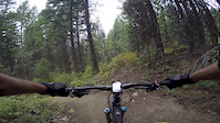
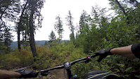
SuperMegaDeth is a local favourite Three different sections divide this trail, each with something a little different to offer. Overall this trail has a little bit of everything starting with some pedally cross country and progressing to an all-mountain DH romp with many fun moves to keep it interesting. Great trail for the intermediate to advanced rider willing to pedal a bit. Take Awesome for fast flow at the bottom, or ride the end of Death for steeper lines and a few drops.
Access Info
The start of SMD is found from the top of Malde Creek Road pedal up towards the Flume then take a left onto the SMD climb. The climb from the Malde Creek Road is short and the top is found at the Bob Marley Bench where you can gear up for the descent. This can be ridden as a shuttle by leaving a car at the King George Road parking lot and driving up to start at the top of Malde Creek. Alternatively, drop a car and ride up Tamarack to the top of Malde Creek from town. For those looking for a physical challenge, ride SMD as a loop by parking at the King George Road ascending on Dukhobor Draw and Tamarack then take the SMD descent to the car.
Local Trail Association
-
Please consider joining or donating to the local trail association to supportdonate to earn trail karma!
trail development & maintenance.
Traditionally Indigenous Territory
More Stats for SMD mountain bike trail trail
-
Altitude change-1,645 ft
-
Altitude min2,346 ft
-
Altitude max4,064 ft
-
Altitude start3,990 ft
-
Altitude end2,346 ft
-
Grade-9.1%
-
Grade max-49.4%
-
Grade min22.6%
-
Distance climb3,205 ft
-
Distance down3 miles
-
Distance flat912 ft
-
Avg time00:38:45
-
Avg reverse time01:17:09
- view trail stats
- Unknown
- Snow Groomed
- Snow Packed
- Snow Covered
- Snow Cover Inadequate
- Freeze/thaw Cycle
- Icy
- Prevalent Mud
- Wet
- Variable
- Ideal
- Dry
- Very Dry
The colour categories are based on what percentage of riders are riding a trail in its intended direction.
- > 96%
- > 90%
- > 80%
- > 70%
- > 50%
- < 50%
- bi-directional trail
- no data
- < 2 days
- < 1 week
- < 2 weeks
- < 1 month
- < 6 months
- > 6 months
- Downhill Only
- Downhill Primary
- Both Directions
- Uphill Primary
- Uphill Only
- One Direction
- Description
- Photos
- Description & Photos
- Videos
- most popular
- popular
- less popular
- not popular
- mountain biking recent
- mountain biking (>6 month)
- hiking (1 year)
- moto (1 year)
- Downhill Ski
- Backcountry Ski
- Nordic Ski
- Snowmobile
Save the current map location and zoom level as your default home location whenever this page is loaded.
SaveSMD Trail Reports
Recent Ridelog Activity on Trail
Past Week
- 0 rides
6 Months
- 17 rides
- 8 miles avg distance
All
- 985 rides
- Last: Oct 30, 2022
Photos
Routes with this trail
Trail Products
6 Reviews & Comments
-
+ 0


SMF= Super mega fun!
This trail is a blast!
Videos

Nearby Trails
- The Flume 0 ft
- Flume And Smd Access 1,099 ft
- Whiskey (upper) 2,201 ft
- Quad Road 2,825 ft
- Whiskey On The Rocks 3,839 ft
- embed SMD trail on your website
- By barry-mclane
& contributors
- #8155 - 9,032 views
- subscribe
- login to download gpx or kml files.