close
-
Layers w
- Weather Layers
- Pro
- Pro
- Pro
- Pro
- Pro
- Pro
- More Layers
- Pro
- Pro
- Pro
- Pro
-
Upgrade to

3D
Trail Conditions
- Unknown
- Snow Groomed
- Snow Packed
- Snow Covered
- Snow Cover Partial
- Freeze/thaw Cycle
- Icy
- Prevalent Mud
- Wet
- Variable
- Ideal
- Dry
- Very Dry
Trail Flow (Ridden Direction)
Trailforks scans users ridelogs to determine the most popular direction each trail is ridden. A good flowing trail network will have most trails flowing in a single direction according to their intension.
The colour categories are based on what percentage of riders are riding a trail in its intended direction.
The colour categories are based on what percentage of riders are riding a trail in its intended direction.
- > 96%
- > 90%
- > 80%
- > 70%
- > 50%
- < 50%
- bi-directional trail
- no data
Trail Last Ridden
Trailforks scans ridelogs to determine the last time a trail was ridden.
- < 2 days
- < 1 week
- < 2 weeks
- < 1 month
- < 6 months
- > 6 months
Trail Ridden Direction
The intended direction a trail should be ridden.
- Downhill Only
- Downhill Primary
- Both Directions
- Uphill Primary
- Uphill Only
- One Direction
Contribute Details
Colors indicate trail is missing specified detail.
- Description
- Photos
- Description & Photos
- Videos
Trail Popularity ?
Trailforks scans ridelogs to determine which trails are ridden the most in the last 9 months.
Trails are compared with nearby trails in the same city region with a possible 25 colour shades.
Think of this as a heatmap, more rides = more kinetic energy = warmer colors.
- most popular
- popular
- less popular
- not popular
ATV/ORV/OHV Filter
Max Vehicle Width
inches
US Cell Coverage
Legend

Radar Time
Activity Recordings
Trailforks uses anonymized public activity data.
?
Activity Recordings
Trailforks uses anonymized public activity data.
?
Personal Heatmap
▶
Activity Types
all
/
none
▶
Options
2
Date range
month
–
Winter Trails
Warning
A routing network for winter maps does not exist. Selecting trails using the winter trails layer has been disabled.
Missing Trails
Most Popular
Least Popular
Trails are colored based on popularity. The more popular a trail is, the more red. Less popular trails trend towards green.
Jump Magnitude Heatmap
Heatmap of where riders jump on trails. Zoom in to see individual jumps, click circles to view jump details.
BC Backroad Status
![map legend]()
Service Road Atlas is a free to use, community-driven service for viewing and creating reports on the numerous back-country service roads around B.C. and Alberta.

Slope Aspect
Direction the slope faces
Trails Deemphasized
Trails are shown in grey.
Only show trails with no bike usage.
Suggested Layers
Based on selected activity type
Save the current map location and zoom level as your default home location whenever this page is loaded.
SaveThis region includes the seven villages in Barnstable which are Barnstable, West Barnstable, Hyannis, Centerville, Osterville, Marstons Mills, and Cotuit
Links
Activities Click to view
- Mountain Bike
349 trails
- Gravel Bike
0 trails
- Adaptive Bike
0 trails
- Horse
22 trails
- Hike
393 trails
- Trail Running
393 trails
- ATV/ORV/OHV
12 trails
- Snowshoe
339 trails
Region Details
- 95
- 137
- 91
- 19
- 2
Region Status
Open as of 2 daysStats
- Avg Trail Rating
- Trails (view details)
- 385
- Trails Mountain Bike
- 349
- Trails Horse
- 22
- Trails Hike
- 393
- Trails Trail Running
- 393
- Trails Observed Trials
- 1
- Trails ATV/ORV/OHV
- 12
- Trails Snowshoe
- 339
- Trails Nordic Ski
- 1
- Total Distance
- 160 miles
- Total Descent Distance
- 53 miles
- Total Descent
- 7,820 ft
- Total Vertical
- 230 ft
- Highest Trailhead
- 231 ft
- Reports
- 3,450
- Photos
- 658
- Ridden Counter
- 39,020
Sub Regions
-
Allan F. Pierce Conservation Area
- 13
- 2
-
Bridge Creek Conservation Area
- 5
- 4
-
Clay Hill Conservation / Barnstable SF
- 12
- 7
- 2
-
Crocker Neck Conservation Area
- 5
- 3
-
Old Jail Lane / Hathaway's Pond
- 31
- 15
- 1
-
Otis Atwood Conservation Area
- 2
- 2
-
Sandy Neck Beach
- 1
- 2
-
West Barnstable Conservation Area (WBCA)
- 36
- 43
- 10
- 2
-
Willow Street
- 13
- 9
- 5
Popular Barnstable Mountain Biking Trails
• 100 ★ 4.0 • 1 mile • 60 ft • 766 •
Popular green difficulty doubletrack. This multi-use trail. On average it takes 6 minutes to complete this trail.
• 100 ★ 4.7 • 1,161 ft • 3 ft • 640 •
A TOT favorite, this short section of trail is a natural pumptrack going over many dirt mounds.
• 100 ★ 5.0 • 4,396 ft • 17 ft • 630 •
Popular green difficulty family friendly singletrack. This multi-use trail can be used both directions and has a easy overall physical rating with a 17 ft green climb. Trail visibility is always easy to follow. On average it takes 6 minutes to complete this trail.
• 90 ★ 4.5 • 2,815 ft • 60 ft • 609 •
Popular blue difficulty family friendly singletrack. This multi-use trail can be used both directions and has a moderate overall physical rating with a 60 ft blue climb. Trail visibility is always easy to follow. On average it takes 6 minutes to complete this trail.
• 85 ★ 4.8 • 1 mile • 119 ft • 566 •
Popular blue difficulty family friendly singletrack. This multi-use trail can be used both directions and has a moderate overall physical rating with a 119 ft blue climb. It features jump and rock garden. Trail visibility is always easy to follow. On average it takes 11 minutes to complete this trail.
• 90 ★ 4.0 • 1,289 ft • 49 ft • 551 •
Popular blue difficulty family friendly singletrack. This multi-use trail can be used both directions and has a moderate overall physical rating with a 49 ft blue climb. Trail visibility is always easy to follow. On average it takes 2 minutes to complete this trail.
• 95 ★ 0.0 • 1,293 ft • 30 ft • 536 •
Popular blue difficulty family friendly singletrack. This multi-use trail can be used both directions and has a moderate overall physical rating with a 30 ft blue climb. Trail visibility is always easy to follow. On average it takes 2 minutes to complete this trail.
• 90 ★ 4.3 • 4,249 ft • 109 ft • 531 •
Some of the best singletrack in West Barnstable. This trail has tight singletrack with technical sections, punchy climbs, multiple rock features, and rock gardens. This is a must ride. This trail is best ridden from West to East but it...
Barnstable Mountain Bike Routes
★ 3.8 • 8 miles • 534 ft • 16 • Loop •
This route consists of the best trails in West Barnstable Conservation Area. It has some of the best...
★ 4.0 • 7 miles • 417 ft • 5 • Loop •
Sunday Lunch is a back and forth, out and back loop that should challenge some riders but make for a nice...
30 miles • 1,412 ft • 34 • Point to Point •
Leg #3 – Hyannis to Brewster The third leg in our trans-Cape endeavor starts in the parking lot of Cape...
★ 2.5 • 17 miles • 1,054 ft • 18 • Loop •
The expert loop of the 2016 Kona Mountain Bike Adventure Series Ride at Trail of Tears. This ride...
★ 4.0 • 2 miles • 102 ft • 2 • Point to Point •
This section of the Cape Cod Pathways offers scenic views of tidal marshland, and traverses near bogs and...
5 miles • 97 ft • 4 • Loop •
This is the route for the 2023 Toys for Tots Adaptive bike and Family Fun rides.
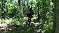
Photos of Barnstable Mountain Bike
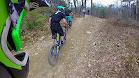
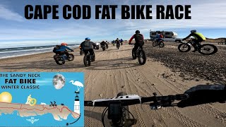
Videos of Barnstable Mountain Bike
0:08 |
968 |
Jun 9, 2019
trail: Miguel
4:26 |
723 |
May 9, 2015
6:22 |
253 |
Dec 6, 2022

trail: Big Ring Trail
2:09 |
575 |
Oct 22, 2018 , Barnstable
Current Trail Warnings
| status | trail | date | condition | user | info |
|---|---|---|---|---|---|
| Freefall | Jun 3, 2026 @ 11:09am (Pacific/Midway) Jun 3, 2026 | Ideal | dhowland | Large tree down across trail just east of... |
Recent Trail Reports
| status | trail | date | condition | info | user |
|---|---|---|---|---|---|
| The Hammer | Jun 20, 2026 @ 10:23am (America/New_York) 2 days | Unknown | Mtbiker1953 | ||
| Festivities | Jun 19, 2026 @ 10:55am (America/New_York) 3 days | Unknown | tjharris78 | ||
| Whats Left of Mulberry | Jun 10, 2026 @ 6:54am (Pacific/Midway) Jun 10, 2026 | Ideal | dhowland | ||
| C-O-MM and Get It! | Jun 10, 2026 @ 6:54am (Pacific/Midway) Jun 10, 2026 | Ideal | dhowland | ||
| Danforth Trail | Jun 10, 2026 @ 6:54am (Pacific/Midway) Jun 10, 2026 | Ideal | dhowland | ||
| VP Trail | Jun 10, 2026 @ 6:54am (Pacific/Midway) Jun 10, 2026 | Ideal | dhowland | ||
| Humpty Dumpty | Jun 10, 2026 @ 6:54am (Pacific/Midway) Jun 10, 2026 | Ideal | dhowland | ||
| North Ridge Bypass | Jun 10, 2026 @ 6:54am (Pacific/Midway) Jun 10, 2026 | Ideal | dhowland | ||
| Witch Out | Jun 10, 2026 @ 6:54am (Pacific/Midway) Jun 10, 2026 | Ideal | dhowland | ||
| Charlie's Bypass | Jun 10, 2026 @ 6:54am (Pacific/Midway) Jun 10, 2026 | Ideal | dhowland |
Activity Feed
| username | action | type | title | date |
|---|---|---|---|---|
| bschrameck | wishlist | route | activity #97474832 | Jun 21, 2026 @ 5:30am 22 hours |
| DouglasyjqGlt | wishlist | region | activity #97474509 | Jun 21, 2026 @ 5:25am 22 hours |
| Mtbiker1953 | add | report | activity #97392382 | Jun 20, 2026 @ 7:23am 2 days |
| Boodles07 | add | report | activity #97344809 | Jun 19, 2026 @ 2:26pm 3 days |
| kz174 | add | report | activity #97343412 | Jun 19, 2026 @ 2:03pm 3 days |
Recent Comments
| username | type | title | comment | date |
|---|---|---|---|---|
| report | Looking into it! | Jun 4, 2026 @ 3:22am Jun 4, 2026 | ||
| trail | Need chainsaw | Jun 1, 2026 @ 3:56pm Jun 1, 2026 | ||
| report | Cut n cleared BY Bob Lauterbach | May 20, 2026 @ 8:51am May 20, 2026 | ||
| report | Its actually on the green connector on the... | Apr 27, 2026 @ 6:38am Apr 27, 2026 | ||
| report | Where about? | Apr 27, 2026 @ 5:20am Apr 27, 2026 |
Local Badges
-

Completionist - Otis Atwood - CC100034 awarded -

Completionist - Clay Hill / Barnstable SF - CC10008 awarded -

Completionist - Willow St - CC10004 awarded -

Completionist - Sandy Neck - CC10006 awarded -

Top 10 Trails22 awarded -

10 Green Trails335 awarded
Activity Type Stats
| activitytype | trails | distance | descent | descent distance | total vertical | rating | global rank | state rank | photos | reports | routes | ridelogs |
|---|---|---|---|---|---|---|---|---|---|---|---|---|
| Mountain Bike | 349 | 149 miles | 7,546 ft | 49 miles | 230 ft | #412 | #151 | 604 | 3,450 | 38 | 23,803 | |
| Horse | 22 | 25 miles | 390 ft | 5 miles | 167 ft | #1,724 | #979 | 2 | 114 | 4 | ||
| Hike | 393 | 160 miles | 7,818 ft | 53 miles | 230 ft | #337 | #160 | 33 | 3,459 | 14 | 888 | |
| Trail Running | 393 | 160 miles | 7,818 ft | 53 miles | 230 ft | #460 | #180 | 13 | 3,461 | 12 | 1,192 | |
| Observed Trials | 1 | 1 mile | 16 ft | 1,237 ft | 10 ft | 7 | 5 | 15 | ||||
| ATV/ORV/OHV | 12 | 14 miles | 75 ft | 2 miles | 16 ft | #818 | #366 | 97 | 4 | |||
| Snowshoe | 339 | 133 miles | 6,654 ft | 42 miles | 230 ft | #66 | #18 | 839 | 17 | |||
| Nordic Ski | 1 | 1 mile | 16 ft | 1,237 ft | 10 ft | 13 |
Frequently Asked Questions About Barnstable
▼
What are the best places to ride in Barnstable?
Barnstable has 14 areas to explore for mountain biking. The top rated areas are:
▼
What are the highest rated mountain biking trails in Barnstable?
The highest rated mountain biking trails in Barnstable are:
- The Flats (4.4/5)
- Deer Run (4.4/5)
- North Ridge (4.3/5)
- Duck & Cover (4.2/5)
- Tractor Tire Trail (4.2/5)
▼
What is the best time of the year to ride in Barnstable?
Based on ride log data, the most popular months to ride in Barnstable are:
- July (523 activities)
- August (411 activities)
- September (358 activities)
▼
Where can I park to ride in Barnstable?
There are 36 parking locations listed in Barnstable. The most popular parking spots are: View all parking and trailhead locations on the map to plan your visit.
Activities
Trails
Points of Interest
- By waterbooy
 CC NEMBA & contributors
 - Admins: CC NEMBA, capecolin
- #18991 - 8,952 views
- barnstable activity log | embed map of Barnstable mountain bike trails | barnstable mountain biking points of interest polygons
Downloading of trail gps tracks in kml & gpx formats is enabled for Barnstable.
You must login to download files.