close
-
Layers w
- Weather Layers
- Pro
- Pro
- Pro
- Pro
- Pro
- Pro
- More Layers
- Pro
- Pro
- Pro
- Pro
-
Upgrade to

3D
Trail Conditions
- Unknown
- Snow Groomed
- Snow Packed
- Snow Covered
- Snow Cover Partial
- Freeze/thaw Cycle
- Icy
- Prevalent Mud
- Wet
- Variable
- Ideal
- Dry
- Very Dry
Trail Flow (Ridden Direction)
Trailforks scans users ridelogs to determine the most popular direction each trail is ridden. A good flowing trail network will have most trails flowing in a single direction according to their intension.
The colour categories are based on what percentage of riders are riding a trail in its intended direction.
The colour categories are based on what percentage of riders are riding a trail in its intended direction.
- > 96%
- > 90%
- > 80%
- > 70%
- > 50%
- < 50%
- bi-directional trail
- no data
Trail Last Ridden
Trailforks scans ridelogs to determine the last time a trail was ridden.
- < 2 days
- < 1 week
- < 2 weeks
- < 1 month
- < 6 months
- > 6 months
Trail Ridden Direction
The intended direction a trail should be ridden.
- Downhill Only
- Downhill Primary
- Both Directions
- Uphill Primary
- Uphill Only
- One Direction
Contribute Details
Colors indicate trail is missing specified detail.
- Description
- Photos
- Description & Photos
- Videos
Trail Popularity ?
Trailforks scans ridelogs to determine which trails are ridden the most in the last 9 months.
Trails are compared with nearby trails in the same city region with a possible 25 colour shades.
Think of this as a heatmap, more rides = more kinetic energy = warmer colors.
- most popular
- popular
- less popular
- not popular
ATV/ORV/OHV Filter
Max Vehicle Width
inches
US Cell Coverage
Legend

Radar Time
Activity Recordings
Trailforks uses anonymized public activity data.
?
Activity Recordings
Trailforks uses anonymized public activity data.
?
Personal Heatmap
▶
Activity Types
all
/
none
▶
Options
2
Date range
month
–
Winter Trails
Warning
A routing network for winter maps does not exist. Selecting trails using the winter trails layer has been disabled.
Missing Trails
Most Popular
Least Popular
Trails are colored based on popularity. The more popular a trail is, the more red. Less popular trails trend towards green.
Jump Magnitude Heatmap
Heatmap of where riders jump on trails. Zoom in to see individual jumps, click circles to view jump details.
BC Backroad Status
![map legend]()
Service Road Atlas is a free to use, community-driven service for viewing and creating reports on the numerous back-country service roads around B.C. and Alberta.

Slope Aspect
Direction the slope faces
Trails Deemphasized
Trails are shown in grey.
Only show trails with no bike usage.
Suggested Layers
Based on selected activity type
Save the current map location and zoom level as your default home location whenever this page is loaded.
Save
No description for Beaver has been added yet!
Login or register to submit one.
Activities Click to view
- Mountain Bike
128 trails
- E-Bike
42 trails
- Gravel Bike
7 trails
- Adaptive Bike
9 trails
- Winter Fat Bike
36 trails
- Horse
63 trails
- Hike
131 trails
- Trail Running
129 trails
- Dirtbike/Moto
30 trails
- ATV/ORV/OHV
28 trails
- Downhill Ski
43 trails
Region Details
- 32
- 1
- 20
- 54
- 19
- 1
Region Status
OpenAdaptive Bike Stats
- Global Ranking
- #324
- State Ranking
- #1,633
- Trails (view details)
- 9
- Trails Mountain Bike
- 128
- Trails E-Bike
- 42
- Trails Gravel Bike
- 7
- Trails Adaptive Bike
- 9
- Trails Winter Fat Bike
- 36
- Trails Horse
- 63
- Trails Hike
- 131
- Trails Trail Running
- 129
- Trails Dirtbike/Moto
- 30
- Trails ATV/ORV/OHV
- 28
- Trails Snowmobile
- 3
- Trails Snowshoe
- 2
- Trails Downhill Ski
- 43
- Total Distance
- 38 miles
- Total Descent Distance
- 17 miles
- Total Descent
- 5,279 ft
- Total Vertical
- 4,324 ft
- Reports
- 4
Popular Beaver Adaptive Biking Trails
• 5 ★ 0.0 • 10 miles • 2,439 ft • 3 •
OHV segment of the Great Western Trail from State Road 72 to Last Chance Road near Hilgard Mountain. Beautiful alpine forest riding around 10,000 ft elevation.
Photos of Beaver
Videos of Beaver
trail: Tushar Ridge (Upper)
2:00 |
50 |
Sep 1, 2019
trail: Puffer Lake - Skyline
3:40 |
101 |
Sep 1, 2019
trail: Endor
2:39 |
80 |
Sep 1, 2019
trail: Swoop Flow
2:38 |
250 |
Sep 1, 2019
youtuber
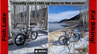
![Warm winter fat biking at Fish Lake! |...]()

trail: Bowery Bypass
31:12 |
36 |
Jan 2, 2026 , Beaver
youtuber
![Warm winter fat biking at Fish Lake! |...]()
trail: Fish Lake Perimeter
31:12 |
39 |
Jan 2, 2026 , Beaver
youtuber
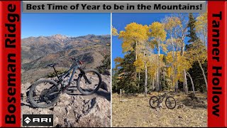
![All-Time Fall Time on Tanner Hollow Trail! |...]()
trail: Tanner Hollow - Big John
59:00 |
67 |
Oct 28, 2025 , Beaver
youtuber
![All-Time Fall Time on Tanner Hollow Trail! |...]()

59:00 |
59 |
Oct 28, 2025 , Beaver
Recent Trail Reports
| status | trail | date | condition | info | user |
|---|---|---|---|---|---|
| Tushar Ridge | Jul 4, 2022 @ 12:40pm Jul 4, 2022 | Dry | j25fAoCN | ||
| Monarch DT | Jul 26, 2020 @ 3:49pm Jul 26, 2020 | Ideal | tysonclay |
Recent Comments
| username | type | title | comment | date |
|---|---|---|---|---|
| trail | All hail the Sarlacc Pit! | Jul 19, 2023 @ 7:35pm Jul 19, 2023 |
Activity Type Stats
| activitytype | trails | distance | descent | descent distance | total vertical | rating | global rank | state rank | photos | reports | routes | ridelogs |
|---|---|---|---|---|---|---|---|---|---|---|---|---|
| Mountain Bike | 128 | 378 miles | 59,137 ft | 144 miles | 6,135 ft | #689 | #261 | 469 | 136 | 8 | 2,952 | |
| E-Bike | 42 | 120 miles | 14,888 ft | 41 miles | 5,266 ft | #1,389 | #861 | 90 | 4 | 86 | ||
| Gravel Bike | 7 | 41 miles | 5,387 ft | 17 miles | 4,222 ft | #347 | #935 | 3 | 1 | 38 | ||
| Adaptive Bike | 9 | 38 miles | 5,279 ft | 17 miles | 4,324 ft | #324 | #1,633 | 4 | ||||
| Winter Fat Bike | 36 | 125 miles | 15,466 ft | 40 miles | 5,299 ft | #56 | #856 | 2 | ||||
| Horse | 63 | 202 miles | 35,381 ft | 72 miles | 5,899 ft | #131 | #387 | 3 | 27 | 1 | 1 | |
| Hike | 131 | 380 miles | 59,213 ft | 144 miles | 6,135 ft | #309 | #151 | 49 | 133 | 6 | 369 | |
| Trail Running | 129 | 378 miles | 59,193 ft | 144 miles | 6,135 ft | #323 | #127 | 133 | 6 | 100 | ||
| Dirtbike/Moto | 30 | 115 miles | 12,657 ft | 37 miles | 5,066 ft | #288 | #138 | 13 | 11 | |||
| ATV/ORV/OHV | 28 | 111 miles | 11,893 ft | 34 miles | 5,066 ft | #159 | #69 | 3 | 13 | 15 | ||
| Snowmobile | 3 | 21 miles | 3,757 ft | 9 miles | 3,691 ft | 2 | ||||||
| Snowshoe | 2 | 15 miles | 2,090 ft | 4 miles | 3,967 ft | 2 | 13 | |||||
| Downhill Ski | 43 | 15 miles | 11,988 ft | 14 miles | 1,342 ft | #426 | #164 | 221 |
Frequently Asked Questions About Beaver
▼
What are the best places to ride in Beaver?
Beaver has 6 areas to explore for adaptive biking. The top rated areas are:
▼
Where can I park to ride in Beaver?
There are 20 parking locations listed in Beaver. The most popular parking spots are:
- Mammoth Crossing Trailhead
- Elk Meadows
- Big John Flat Trailhead
- Parking (Lake Stream Trailhead)
- Bullion Falls Trailhead
▼
What is the longest trail in Beaver?
The longest trail in Beaver is GWT - SR72 to Last Chance at 9.6 miles. View all trails sorted by distance.
▼
What are the best & highest rated hiking trails in Beaver?
The best hiking trails in Beaver are:
- Miners Park Access
- Poison Creek - South Fork Bullion
- Sage Advice
- Upper Cathedral Valley Overlook
- Mud Lake - Blue Lake
Activities
Trails
Points of Interest
- Big John CUA Dispersed Camping
- Kents Lake Campground Camping
- Anderson Meadow Campground Camping
- Timid Springs Dispersed Camping
- Big John Flat Camping
- Wood Sender TTF
- Old Line Shack Sight
- Bullion Falls [waterfall] Other
- Delano Peak Summit
- Copper Belt Peak Summit
- Delano Peak (12,172 ft)
- Mount Baldy (12,090 ft)
- Mount Holly (11,962 ft)
- By canadaka
 Trailforks & contributors
 - Admins: jkwilliamz, UtahJohn, jpmcghee, jasonmalczyk
- #4827 - 10,013 views
- beaver activity log | embed map of Beaver mountain bike trails | beaver mountain biking points of interest
Downloading of trail gps tracks in kml & gpx formats is enabled for Beaver.
You must login to download files.