close
-
Layers w
- Weather Layers
- Pro
- Pro
- Pro
- Pro
- Pro
- Pro
- More Layers
- Pro
- Pro
- Pro
- Pro
-
Upgrade to

3D
Trail Conditions
- Unknown
- Snow Groomed
- Snow Packed
- Snow Covered
- Snow Cover Partial
- Freeze/thaw Cycle
- Icy
- Prevalent Mud
- Wet
- Variable
- Ideal
- Dry
- Very Dry
Trail Flow (Ridden Direction)
Trailforks scans users ridelogs to determine the most popular direction each trail is ridden. A good flowing trail network will have most trails flowing in a single direction according to their intension.
The colour categories are based on what percentage of riders are riding a trail in its intended direction.
The colour categories are based on what percentage of riders are riding a trail in its intended direction.
- > 96%
- > 90%
- > 80%
- > 70%
- > 50%
- < 50%
- bi-directional trail
- no data
Trail Last Ridden
Trailforks scans ridelogs to determine the last time a trail was ridden.
- < 2 days
- < 1 week
- < 2 weeks
- < 1 month
- < 6 months
- > 6 months
Trail Ridden Direction
The intended direction a trail should be ridden.
- Downhill Only
- Downhill Primary
- Both Directions
- Uphill Primary
- Uphill Only
- One Direction
Contribute Details
Colors indicate trail is missing specified detail.
- Description
- Photos
- Description & Photos
- Videos
Trail Popularity ?
Trailforks scans ridelogs to determine which trails are ridden the most in the last 9 months.
Trails are compared with nearby trails in the same city region with a possible 25 colour shades.
Think of this as a heatmap, more rides = more kinetic energy = warmer colors.
- most popular
- popular
- less popular
- not popular
ATV/ORV/OHV Filter
Max Vehicle Width
inches
US Cell Coverage
Legend

Radar Time
Activity Recordings
Trailforks uses anonymized public activity data.
?
Activity Recordings
Trailforks uses anonymized public activity data.
?
Personal Heatmap
▶
Activity Types
all
/
none
▶
Options
2
Date range
month
–
Winter Trails
Warning
A routing network for winter maps does not exist. Selecting trails using the winter trails layer has been disabled.
Missing Trails
Most Popular
Least Popular
Trails are colored based on popularity. The more popular a trail is, the more red. Less popular trails trend towards green.
Jump Magnitude Heatmap
Heatmap of where riders jump on trails. Zoom in to see individual jumps, click circles to view jump details.
BC Backroad Status
![map legend]()
Service Road Atlas is a free to use, community-driven service for viewing and creating reports on the numerous back-country service roads around B.C. and Alberta.

Slope Aspect
Direction the slope faces
Trails Deemphasized
Trails are shown in grey.
Only show trails with no bike usage.
Suggested Layers
Based on selected activity type
Save the current map location and zoom level as your default home location whenever this page is loaded.
Save
No description for Bruson has been added yet!
Login or register to submit one.
Primary Trail Type: Cross-Country
Land Status: Ski Resort
This region uses the Uk/Euro style trail grading system.
Activities Click to view
- Mountain Bike
56 trails
- E-Bike
54 trails
- Hike
57 trails
- Trail Running
57 trails
Region Details
- 14
- 9
- 16
- 11
Region Status
Caution as of Oct 11, 2025Stats
- Avg Trail Rating
- Trails (view details)
- 50
- Trails Mountain Bike
- 57
- Trails E-Bike
- 54
- Trails Hike
- 57
- Trails Trail Running
- 57
- Total Distance
- 33 miles
- Total Descent Distance
- 15 miles
- Total Descent
- 12,840 ft
- Total Vertical
- 4,870 ft
- Highest Trailhead
- 8,092 ft
- Reports
- 299
- Photos
- 28
- Ridden Counter
- 9,951
Popular Bruson Mountain Biking Trails
• 100 ★ 5.0 • 3,796 ft • 15 ft • 443 •
Popular blue difficulty singletrack. This multi-use trail can be used downhill primary and has a moderate overall physical rating with a 15 ft green climb. Trail visibility is always easy to follow. On average it takes 7 minutes to complete this trail.
• 100 ★ 5.0 • 3 miles • 87 ft • 405 •
Highly rated popular red difficulty alpine singletrack. This multi-use trail can be used downhill primary and has a moderate overall physical rating. Trail visibility is always easy to follow. On average it takes 7 minutes to complete this trail.
• 100 ★ 4.5 • 1,581 ft • 0 ft • 402 •
Popular red difficulty singletrack. This multi-use trail can be used downhill primary and has a moderate overall physical rating with a 0 ft green climb. Trail visibility is always easy to follow. On average it takes 2 minutes to complete this trail.
• 100 ★ 5.0 • 4,478 ft • 6 ft • 402 •
Popular blue difficulty singletrack. This multi-use trail can be used downhill only and has a easy overall physical rating with a 6 ft green climb. Trail visibility is always easy to follow. On average it takes 6 minutes to complete this trail.
• 100 ★ 5.0 • 1,496 ft • 0 ft • 401 •
Popular red difficulty singletrack. This multi-use trail can be used downhill primary and has a easy overall physical rating. Trail visibility is always easy to follow. On average it takes minutes to complete this trail.
• 95 ★ 4.5 • 5,174 ft • 234 ft • 354 •
Highly rated popular red difficulty alpine singletrack. This multi-use trail can be used downhill primary and has a moderate overall physical rating with a 234 ft green climb. Trail visibility is sometimes hard to follow. On average it takes 13 minutes to complete this trail.
• 100 ★ 4.3 • 610 ft • 3 ft • 353 •
Popular blue difficulty singletrack. This multi-use trail can be used downhill primary and has a easy overall physical rating. Trail visibility is always easy to follow. On average it takes minutes to complete this trail.
• 95 ★ 4.7 • 2,064 ft • 73 ft • 340 •
Popular red difficulty alpine singletrack. This multi-use trail can be used downhill primary and has a moderate overall physical rating with a 73 ft green climb. Trail visibility is always easy to follow. On average it takes 3 minutes to complete this trail.
Bruson Mountain Bike Routes
★ 2.5 • 9 miles • 1,758 ft • 13 • Point to Point •
Variation of the route “15. Six-Blanc – Versegères”, this is for advanced riders only! Although the...
12 miles • 2,935 ft • 16 • Point to Point •
With a surrounding landscape of great beauty and a breath-taking view, this route of medium to advanced...
4 miles • 149 ft • 0 •
A trail for beginners, it lets you ride through the serene Bruson forest via the Route de la Forêt....
5 miles • 82 ft • 0 • Point to Point •
As you leave La Côt, take a small path crossing the main road on two occasions. Then take a small path on...
• 29 miles • 11,566 ft • 19 •
Photos of Bruson Mountain Bike
Videos of Bruson Mountain Bike
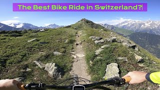
trail: Dzeu de la Tita
24:19 |
65 |
Jun 30, 2025 , Verbier

trail: Vintsiè Rodze
24:19 |
62 |
Jun 30, 2025 , Verbier

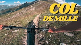
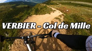
trail: Mille - Servay
24:19 |
71 |
Jun 30, 2025 , Verbier

trail: Mille - Servay
24:19 |
68 |
Jun 30, 2025 , Verbier

trail: Mille - Servay
24:19 |
71 |
Jun 30, 2025 , Verbier
trail: Mille - Servay
5:00 |
97 |
Mar 25, 2025 , Verbier

trail: Mille - Servay
7:47 |
102 |
Sep 5, 2024 , Verbier
trail: Mille - Servay
7:47 |
151 |
Sep 5, 2024 , Verbier
Recent Trail Reports
| status | trail | date | condition | info | user |
|---|---|---|---|---|---|
| L'Aleçon | Oct 12, 2025 @ 8:09am (Europe/Zurich) Oct 11, 2025 | Variable | LionelBloch | ||
| Pasay - Lardzay | Oct 12, 2025 @ 8:09am (Europe/Zurich) Oct 11, 2025 | Variable | LionelBloch | ||
| Crête de Bruson | Oct 12, 2025 @ 8:09am (Europe/Zurich) Oct 11, 2025 | Ideal | LionelBloch | ||
| Six Blanc - Montagne de Moay | Oct 12, 2025 @ 8:09am (Europe/Zurich) Oct 11, 2025 | Ideal | LionelBloch | ||
| Moay - Six Blanc | Oct 12, 2025 @ 8:09am (Europe/Zurich) Oct 11, 2025 | Ideal | LionelBloch | ||
| La Vinteure - Moay | Oct 12, 2025 @ 8:09am (Europe/Zurich) Oct 11, 2025 | Ideal | LionelBloch | ||
| La Côt - La Vinteure | Oct 12, 2025 @ 8:09am (Europe/Zurich) Oct 11, 2025 | Ideal | LionelBloch | ||
| La Darbellaire | Oct 12, 2025 @ 8:09am (Europe/Zurich) Oct 11, 2025 | Ideal | LionelBloch | ||
| La Lui C1 | Oct 12, 2025 @ 8:09am (Europe/Zurich) Oct 11, 2025 | Ideal | LionelBloch | ||
| Dzeu de la Tita | Oct 12, 2025 @ 8:09am (Europe/Zurich) Oct 11, 2025 | Ideal | LionelBloch |
Activity Feed
| username | action | type | title | date |
|---|---|---|---|---|
| SVN719 | wishlist | trail | activity #97709024 | Jun 24, 2026 @ 10:43am 2 days |
| Pedromptorres | ridden | trail | activity #97379863 and 1 more | Jun 20, 2026 @ 4:08am Jun 20, 2026 |
| theclumsyninja | wishlist | route | activity #97374510 and 1 more | Jun 20, 2026 @ 2:20am Jun 20, 2026 |
| OliverVM7 | wishlist | trail | activity #96912684 | Jun 13, 2026 @ 1:42pm Jun 13, 2026 |
| BertramYy6iNc | wishlist | route | activity #96208335 | Jun 3, 2026 @ 11:37pm Jun 3, 2026 |
Recent Comments
| username | type | title | comment | date |
|---|---|---|---|---|
| trail | please vote the rating, then the admin team... | Sep 22, 2025 @ 12:49am Sep 22, 2025 | ||
| trail | Definitely worth a blue rather than black. | Sep 21, 2025 @ 2:16pm Sep 21, 2025 | ||
| trail | Known as Tobogan, locally. | Aug 16, 2025 @ 11:45pm Aug 16, 2025 | ||
| trail | Awesome flowy/tech trail, nothing too... | Jul 10, 2025 @ 3:26am Jul 10, 2025 | ||
| trail | Reddish blue, some steeper sections in the... | Jun 30, 2025 @ 10:32am Jun 30, 2025 |
Nearby Areas
| name | distance | ||||
|---|---|---|---|---|---|
| Verbier | 9 | 36 | 4.3 km | ||
| Verbier Bike Park | 1 | 4 | 4.3 km | ||
| Champex | 2 | 9 | 4.8 km | ||
| La Tzoumaz | 3 | 7.6 km | |||
| Haut Val de Bagnes | 8.8 km |
Local Badges
-

Completionist0 awarded
Activity Type Stats
| activitytype | trails | distance | descent | descent distance | total vertical | rating | global rank | state rank | photos | reports | routes | ridelogs |
|---|---|---|---|---|---|---|---|---|---|---|---|---|
| Mountain Bike | 56 | 33 miles | 12,838 ft | 15 miles | 4,869 ft | #2,611 | #32 | 28 | 299 | 5 | 922 | |
| E-Bike | 54 | 31 miles | 11,260 ft | 14 miles | 4,869 ft | #1,920 | #43 | 295 | 4 | 224 | ||
| Hike | 57 | 33 miles | 12,838 ft | 15 miles | 4,869 ft | #2,549 | #40 | 299 | 2 | 88 | ||
| Trail Running | 57 | 33 miles | 12,838 ft | 15 miles | 4,869 ft | #1,974 | #34 | 299 | 2 | 49 |
Frequently Asked Questions About Bruson
▼
What are the highest rated mountain biking trails in Bruson?
The highest rated mountain biking trails in Bruson are:
- Mille - Servay (4.7/5)
- Vintsiè Rodze (4.4/5)
- Dzeu de la Tita (4.4/5)
- Dzeu de Propourri l (4.3/5)
- La Payanne (4.2/5)
▼
What is the best time of the year to ride in Bruson?
Based on ride log data, the most popular months to ride in Bruson are:
- August (6 activities)
- July (3 activities)
- September (2 activities)
▼
Where can I park to ride in Bruson?
Check the Bruson trail map for trailhead and parking information. Community members regularly update access and parking details for trails in the area.
▼
What is the longest trail in Bruson?
The longest trail in Bruson is Mille - Servay at 3.3 miles. View all trails sorted by distance.
- By brenthillier
 NSMBA TRAILFORKS & contributors
 - Admins: VS-Admin
- #4579 - 4,537 views
- bruson activity log | embed map of Bruson mountain bike trails | bruson mountain biking points of interest
Downloading of trail gps tracks in kml & gpx formats is enabled for Bruson.
You must login to download files.