close
-
Layers w
- Weather Layers
- Pro
- Pro
- Pro
- Pro
- Pro
- Pro
- More Layers
- Pro
- Pro
- Pro
- Pro
-
Upgrade to

3D
Trail Conditions
- Unknown
- Snow Groomed
- Snow Packed
- Snow Covered
- Snow Cover Partial
- Freeze/thaw Cycle
- Icy
- Prevalent Mud
- Wet
- Variable
- Ideal
- Dry
- Very Dry
Trail Flow (Ridden Direction)
Trailforks scans users ridelogs to determine the most popular direction each trail is ridden. A good flowing trail network will have most trails flowing in a single direction according to their intension.
The colour categories are based on what percentage of riders are riding a trail in its intended direction.
The colour categories are based on what percentage of riders are riding a trail in its intended direction.
- > 96%
- > 90%
- > 80%
- > 70%
- > 50%
- < 50%
- bi-directional trail
- no data
Trail Last Ridden
Trailforks scans ridelogs to determine the last time a trail was ridden.
- < 2 days
- < 1 week
- < 2 weeks
- < 1 month
- < 6 months
- > 6 months
Trail Ridden Direction
The intended direction a trail should be ridden.
- Downhill Only
- Downhill Primary
- Both Directions
- Uphill Primary
- Uphill Only
- One Direction
Contribute Details
Colors indicate trail is missing specified detail.
- Description
- Photos
- Description & Photos
- Videos
Trail Popularity ?
Trailforks scans ridelogs to determine which trails are ridden the most in the last 9 months.
Trails are compared with nearby trails in the same city region with a possible 25 colour shades.
Think of this as a heatmap, more rides = more kinetic energy = warmer colors.
- most popular
- popular
- less popular
- not popular
ATV/ORV/OHV Filter
Max Vehicle Width
inches
US Cell Coverage
Legend

Radar Time
Activity Recordings
Trailforks uses anonymized public activity data.
?
Activity Recordings
Trailforks uses anonymized public activity data.
?
Personal Heatmap
▶
Activity Types
all
/
none
▶
Options
2
Date range
month
–
Winter Trails
Warning
A routing network for winter maps does not exist. Selecting trails using the winter trails layer has been disabled.
Missing Trails
Most Popular
Least Popular
Trails are colored based on popularity. The more popular a trail is, the more red. Less popular trails trend towards green.
Jump Magnitude Heatmap
Heatmap of where riders jump on trails. Zoom in to see individual jumps, click circles to view jump details.
BC Backroad Status
![map legend]()
Service Road Atlas is a free to use, community-driven service for viewing and creating reports on the numerous back-country service roads around B.C. and Alberta.

Slope Aspect
Direction the slope faces
Trails Deemphasized
Trails are shown in grey.
Only show trails with no bike usage.
Suggested Layers
Based on selected activity type
Save the current map location and zoom level as your default home location whenever this page is loaded.
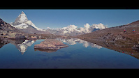
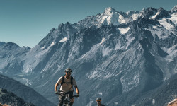
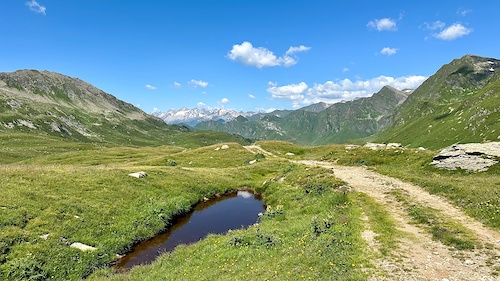
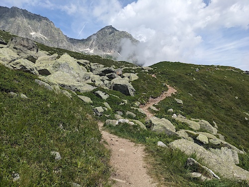
Save"Valais is a land of adventure par excellence, a vast playground for altitude junkies. This is where well-marked mountain-bike trails lead past rushing mountain streams and Alpine lakes, or wind their way over mountainsides and through dense forests. Thanks to public transport and aerial cableways, bikers are faced with no end of possibilities when planning their tour at any level."
"Véritable paradis des aventuriers, le Valais est un immense terrain de jeu en altitude. Parfaitement balisées, les pistes VTT longent des torrents impétueux et des lacs alpins ou serpentent à flanc de montagne en s’enfonçant parfois dans de majestueuses forêts. Grâce aux transports publics et aux remontées mécaniques, il est possible de planifier une foule de parcours aux degrés de difficultés divers."
"Das Wallis ist das perfekte Abenteuerland, eine unermessliche Spielwiese an Höhenmetern. Denn hier führen bestens markierte Mountainbike-Strecken vorbei an sprudelnden Bergbächen und Alpseen oder schlängeln sich über Bergflanken und durch dichte Wälder. Dank den öffentlichen Verkehrsmitteln und Bergbahnen stehen unzählige Möglichkeiten offen, um Touren für jedes Niveau zu planen."
eBikes Allowed:
Yes
AKA: Wallis
Links
This region uses the Uk/Euro style trail grading system.
Region Supporters & Maintainers
![]()
ITRS Difficulty RatingSponsor
Region Details
- 582
- 398
- 1,295
- 636
- 164
- 12
- 1
Stats
- Avg Trail Rating
- Trails (view details)
- 3,513
- Trails Mountain Bike
- 3,102
- Trails E-Bike
- 2,804
- Trails Gravel Bike
- 93
- Trails Adaptive Bike
- 96
- Trails Horse
- 1
- Trails Hike
- 3,102
- Trails Trail Running
- 3,101
- Trails Snowshoe
- 7
- Trails Downhill Ski
- 250
- Trails Backcountry Ski
- 71
- Trails Nordic Ski
- 8
- Total Distance
- 2,732 miles
- Total Descent
- 1,458,976 ft
- Total Vertical
- 12,350 ft
- Highest Trailhead
- 13,708 ft
- Reports
- 16,266
- Photos
- 2,423
- Ridden Counter
- 287,352
Articles
The Haute Route: Chasing the Spine of the Alps from Verbier to Zermatt
Nov 24, 2025 from pinkbike.com
Big climbs, bigger views, and the kind of descents that erase the memory of every hike-a-bike.
Van der Poel and his MTB Worlds Dream Hinges on One Thing in Crans-Montana
Sep 12, 2025 from pinkbike.com
Van der Poel needs to post clean descents, uphill watts and overcome a fifth-row start to win MTB world title: ‘If he’s stuck in a bottleneck...

XCC Photo Epic: 2025 Zermatt World Championships
Sep 10, 2025 from pinkbike.com
Rainbow stripes were decided in the shadow of the Matterhorn.

Video: Jackson Goldstone Was Ridiculous! | Story Of The Race - 2025 Champéry Downhill World Championships
Sep 9, 2025 from pinkbike.com
Join Ben as he recaps the top results and finds out what happened to Loic Bruni.
Popular Trail Networks
view all areas »Sub Regions
- Aletsch Arena (125)
- Bettmeralp (36)
- Bitsch (10)
- Fiesch (36)
- Riederalp (43)
- Bettmeralp (36)
- Bezirk Brig (302)
- Bezirk Goms (206)
- Bezirk Leuk (294)
- Gampel-Bratsch (51)
- Gampel-Jeizinen (30)
- Leuk (70)
- Leukerbad (81)
- Torrent (49)
- Salgesch (20)
- Turtmann-Unterems (52)
- Turtmanntal (47)
- Varen (20)
- Gampel-Bratsch (51)
- Bezirk Raron (172)
- Ausserberg (8)
- Eischoll (32)
- Kippel (60)
- Lötschental (58)
- Niedergesteln (8)
- Raron (9)
- Steg-Hohtenn (20)
- Unterbäch (39)
- Ausserberg (8)
- Bezirk Visp (321)
- Baltschieder (20)
- Baltschiedertal (20)
- Saas-Fee (38)
- Saas-Fee Saastal (36)
- Stalden VS (49)
- Törbel (123)
- Moosalp Region (119)
- Visp (21)
- Visperterminen (69)
- Baltschieder (20)
- District Conthey (61)
- District d’Hérens (198)
- Ayent (47)
- Anzère (36)
- Evolène (44)
- Hérémence (6)
- Mont-Noble (40)
- Saint-Martin VS (16)
- Vex (38)
- Ayent (47)
- District Entremont (327)
- Bourg-Saint-Pierre (8)
- Liddes (30)
- Orsières (94)
- Sembrancher (11)
- Verbier (183)
- Bruson (56)
- Haut Val de Bagnes (9)
- Verbier (97)
- Verbier Bike Park (23)
- Bourg-Saint-Pierre (8)
- District Martigny (161)
- District Monthey (33)
- Collombey-Muraz (2)
- Monthey (24)
- Saint-Gingolph (2)
- Vouvry (5)
- Collombey-Muraz (2)
- District Saint-Maurice (70)
- Dorénaz (16)
- Evionnaz (2)
- Finhaut (8)
- Massongex (10)
- Saint-Maurice (2)
- Salvan (13)
- Les Marécottes (9)
- Vérossaz (18)
- Dorénaz (16)
- District Sierre (140)
- Chippis (2)
- Crans-Montana (116)
- Grone (5)
- Lens (14)
- Sierre (8)
- Chippis (2)
- District Sion (46)
- Mattertal (250)
- Grächen (53)
- St. Niklaus (13)
- Tasch (16)
- Zermatt (167)
- Zermatt - Matterhorn (162)
- Grächen (53)
- Ovronnaz (195)
- Région Dents du Midi (62)
- Champéry (11)
- Les Crosets (11)
- Morgins (11)
- Morgins BikePark (5)
- Troistorrents (12)
- Val-d'Illiez (17)
- Val d'Anniviers (247)
Popular Valais Mountain Biking Trails
• 100 ★ 4.8 • 1 mile • 31 ft • 1,078 •
Highly rated popular red difficulty singletrack. This mountain bike primary trail. Trail visibility is always easy to follow. On average it takes 9 minutes to complete this trail.
• 75 ★ 4.6 • 4,262 ft • 0 ft • 953 •
A series of berms a rock gardens right under the lift. Steep in places, and rough all over!
• 70 ★ 2.0 • 2,116 ft • 23 ft • 929 •
Popular blue difficulty singletrack. This multi-use trail can be used downhill primary and has a moderate overall physical rating with a 23 ft blue climb. On average it takes 2 minutes to complete this trail.
• 95 ★ 3.5 • 600 ft • 0 ft • 725 •
Popular red difficulty machine groomed. This mountain bike primary trail. On average it takes minutes to complete this trail.
• 75 ★ 3.6 • 505 ft • 0 ft • 713 •
Popular red difficulty singletrack. This mountain bike primary trail. On average it takes minutes to complete this trail.
Valais Mountain Bike Routes
Häxutrail Bike #158 Featured
★ 5.0 • 4 miles • 30 ft • 8 • Point to Point •
The trail begins with a ride down a forest track to approximately 1950m above sea level (ASL) where the...
Jeizi Enduro #118 Featured
★ 5.0 • 8 miles • 3,164 ft • 3 • Shuttled •
Exposed, demanding passages, magnificent views of the valley, rustic hamlets and forests: the descent from...
Visp-Zermatt Bike #150 Featured
★ 5.0 • 23 miles • 4,649 ft • 7 • Point to Point •
Paved: 18km Forest Track: 9km SingleTrail: 11km
Torrenttrail Bike #114 Featured
★ 5.0 • 18 miles • 1,636 ft • 14 • Point to Point •
A cable car takes you from Leukerbad to the Rinderhütte in a relaxed manner - those with stamina can of...
Nesselloop Bike #157 Featured
7 miles • 347 ft • 7 • Point to Point •
Belalp is located on a terrace on the southern flank of Unterbächhorn and . The starting point of this...
Bietschhorn Bike #145 Featured
8 miles • 1,663 ft • 12 • Shuttled •
The Lötschental is a truly magical valley, full of fascinating legends, extraordinary traditions, customs...
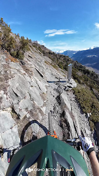
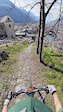
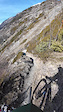
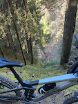
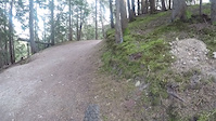
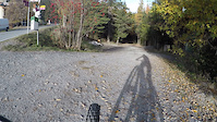
Photos of Valais Mountain Bike
Videos of Valais Mountain Bike
trail: Chés Blancs
0:18 |
6 |
Mar 10, 2026
trail: Chinachra
0:27 |
12 |
Mar 1, 2026
trail: Gattuvolch
0:15 |
10 |
Mar 1, 2026
trail: Gattuvolch
0:15 |
9 |
Mar 1, 2026
trail: Les Dailles
0:02 |
16 |
Dec 30, 2025
2:57 |
27 |
Nov 13, 2025
2:08 |
22 |
Nov 13, 2025
trail: Flowtrail Arnouva Top Part
3:36 |
21 |
Nov 13, 2025
Current Trail Warnings
| status | trail | date | condition | user | info |
|---|---|---|---|---|---|
| Chararogne I Vercorin | Jul 12, 2026 @ 4:32pm (Europe/Zurich) 16 hours | Unknown | dooe84 | Little landslide in the middle. Hard to... | |
| Pointe de Bellevue - La Palla Collombey-Muraz | Jul 11, 2026 @ 6:47pm (Europe/Zurich) 2 days | Unknown | fastsnacker85 | Fermée a cause de éboulement et arbres... | |
| Les Frayés Ayer | Jul 9, 2026 @ 9:02pm (Europe/Zurich) Jul 9, 2026 | Dry | paraenggu VS-Admin | Temporarily closed due to forestry work. |
Recent Trail Reports
National Scenic Trails & Official Routes
-
St.-Gotthard Fünf-Pässe Bike #85
- Mountain Bike
- E-Bike
-
St.-Gotthard Vier-Pässe Bike #84
- Mountain Bike
- E-Bike
Activity Feed
| username | action | type | title | date |
|---|---|---|---|---|
| paraenggu | add | report | activity #99080977 | Jul 12, 2026 @ 11:49pm 6 mins |
| paraenggu | checkin | trail | activity #99080970 | Jul 12, 2026 @ 11:49pm 7 mins |
| paraenggu | ridden | trail | activity #99080965 | Jul 12, 2026 @ 11:49pm 7 mins |
| paraenggu | add | trail | activity #99080942 and 1 more | Jul 12, 2026 @ 11:48pm 8 mins |
| paraenggu | comment | trail | activity #99080528 | Jul 12, 2026 @ 11:31pm 24 mins |
Recent Comments
| username | type | title | comment | date |
|---|---|---|---|---|
| trail | Thanks for the feedback. Split trail and... | Jul 12, 2026 @ 11:31pm 24 mins | ||
| trail | We like this trail uphill. Comin from... | Jul 12, 2026 @ 11:30am 12 hours | ||
| trail | Attention : Shared trail, very popular uphill... | Jul 12, 2026 @ 9:29am 14 hours | ||
| trail | Best trail in town! | Jul 10, 2026 @ 4:07pm 2 days | ||
| trail | It’s trail for the brave, it was fun and... | Jul 9, 2026 @ 11:00am Jul 9, 2026 |
Local Badges
-

Around The Peak7 awarded -

10 Black Trails0 awarded -

10 Black Trails1 awarded -

10 Red Trails86 awarded -

10 Blue Trails37 awarded -

10 Black Trails7 awarded
Bike & Skill Parks
| name | type | city | rating |
|---|---|---|---|
| Verbier Bike Park | bike park | Verbier | |
| Crans-Montana Bikepark | bike park | Crans-Montana | |
| Bikepark Champéry | bike park | Champéry | |
| Zermatt - Matterhorn | bike park | Zermatt | |
| Bikepark St-Luc | bike park | Anniviers |
Upcoming Local Events
Local Products
Local Products
Activity Type Stats
| activitytype | trails | distance | descent | descent distance | total vertical | rating | global rank | state rank | photos | reports | routes | ridelogs |
|---|---|---|---|---|---|---|---|---|---|---|---|---|
| Mountain Bike | 3,100 | 2,262 miles | 1,217,421 ft | 1,379 miles | 10,420 ft | 2,395 | 16,254 | 133 | 49,143 | |||
| E-Bike | 2,804 | 2,052 miles | 1,077,339 ft | 1,236 miles | 9,350 ft | 16 | 15,825 | 101 | 9,614 | |||
| Gravel Bike | 93 | 109 miles | 22,713 ft | 34 miles | 7,283 ft | 101 | 3 | 362 | ||||
| Adaptive Bike | 96 | 102 miles | 21,109 ft | 32 miles | 7,684 ft | 308 | 2 | |||||
| Horse | 1 | 4,816 ft | 128 ft | 2,943 ft | 105 ft | 1,379 | ||||||
| Hike | 3,102 | 2,287 miles | 1,213,268 ft | 1,361 miles | 10,420 ft | 3 | 16,152 | 24 | 13,919 | |||
| Trail Running | 3,101 | 2,285 miles | 1,213,268 ft | 1,361 miles | 10,420 ft | 5 | 16,150 | 24 | 3,205 | |||
| Snowshoe | 7 | 8 miles | 6,463 ft | 2,041 | 294 | |||||||
| Downhill Ski | 250 | 168 miles | 136,759 ft | 150 miles | 9,829 ft | 1,718 | 18,859 | |||||
| Backcountry Ski | 71 | 221 miles | 56,148 ft | 77 miles | 10,873 ft | 1,944 | 9,680 | |||||
| Nordic Ski | 8 | 8 miles | 144 ft | 2,657 ft | 6,463 ft | 2,021 | 3,448 |
Activities
Trails
Points of Interest
- Sparrhoru 3020m Summit
- Lac De Soi Sight
- Pas de Maimbré Viewpoint
- Monte-Leone-Hütte SAC Cabin
- Mannlibode ✝ Viewpoint
- Big Jumps @ Vast&Furious TTF
- Bellwood Viewpoint
- Camping Fafleralp
- Aletschbord Viewpoint
- Tyndall-Denkmal (Tyndall Monument) Sight
- Grand Gendarme (14,465 ft)
- Dom (14,032 ft)
- Aiguille du Croissant (13,868 ft)
- By inversedotch
 & contributors
 - Admins: swiss, trailpapst, VS-Admin
- #8612 - 23,421 views
- valais activity log | embed map of Valais mountain bike trails | valais mountain biking points of interest polygons
Downloading of trail gps tracks in kml & gpx formats is enabled for Valais.
You must login to download files.