close
-
Layers w
- Map Content
- More Layers
- Pro
- Pro
- Pro
- Pro
- Pro
- Pro
- Pro
- Pro
-
Upgrade to

3D
Trail Conditions
- Unknown
- Snow Groomed
- Snow Packed
- Snow Covered
- Snow Cover Partial
- Freeze/thaw Cycle
- Icy
- Prevalent Mud
- Wet
- Variable
- Ideal
- Dry
- Very Dry
Trail Flow (Ridden Direction)
Trailforks scans users ridelogs to determine the most popular direction each trail is ridden. A good flowing trail network will have most trails flowing in a single direction according to their intension.
The colour categories are based on what percentage of riders are riding a trail in its intended direction.
The colour categories are based on what percentage of riders are riding a trail in its intended direction.
- > 96%
- > 90%
- > 80%
- > 70%
- > 50%
- < 50%
- bi-directional trail
- no data
Trail Last Ridden
Trailforks scans ridelogs to determine the last time a trail was ridden.
- < 2 days
- < 1 week
- < 2 weeks
- < 1 month
- < 6 months
- > 6 months
Trail Ridden Direction
The intended direction a trail should be ridden.
- Downhill Only
- Downhill Primary
- Both Directions
- Uphill Primary
- Uphill Only
- One Direction
Contribute Details
Colors indicate trail is missing specified detail.
- Description
- Photos
- Description & Photos
- Videos
Trail Popularity ?
Trailforks scans ridelogs to determine which trails are ridden the most in the last 9 months.
Trails are compared with nearby trails in the same city region with a possible 25 colour shades.
Think of this as a heatmap, more rides = more kinetic energy = warmer colors.
- most popular
- popular
- less popular
- not popular
ATV/ORV/OHV Filter
Max Vehicle Width
inches
US Cell Coverage
Legend

Radar Time
x
Activity Recordings
Trailforks users anonymized public ridelogs from the past 6 months.
- mountain biking recent
- mountain biking (>6 month)
- hiking (1 year)
- moto (1 year)
Activity Recordings
Trailforks users anonymized public skilogs from the past 12 months.
- Downhill Ski
- Backcountry Ski
- Nordic Ski
- Snowmobile
Winter Trails
Warning
A routing network for winter maps does not exist. Selecting trails using the winter trails layer has been disabled.
x
Missing Trails
Most Popular
Least Popular
Trails are colored based on popularity. The more popular a trail is, the more red. Less popular trails trend towards green.
Jump Magnitude Heatmap
Heatmap of where riders jump on trails. Zoom in to see individual jumps, click circles to view jump details.
Trails Deemphasized
Trails are shown in grey.
Only show trails with NO bikes.
Save the current map location and zoom level as your default home location whenever this page is loaded.
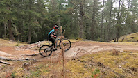
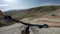
SaveFunction Junction is the hub of the Cheakamus trail area. The topography is defined by the Cheakamus river watershed and Cheakamus lake. There is parking & a map kiosk adjacent to the Highway 99 stoplight at the Riverside trail head.
The area offers multi-use trails, interpretive signage, a rather stunning suspension bridge, river views and evident volcanic activity. With the addition of the Cheakamus Crossing neighbourhood following the 2010 Olympics, this area has become extremely popular and well used by many different user groups. Expect to encounter families with young children, dog walkers, trail runners, hikers, and other bikers at any time of the day and around any corner. Always ride in control, leave your headphones at home, and always greet other users with a smile, hello and a thank you.
Food and beverage options abound in Function Junction just across the highway, and the Whistler Brewery is a great place for a post ride drink If you need bike parts or service, Function also has a number of bike shops to help you out.
Land Status: Crown Land
 google parking directions
 Activities Click to view
- Mountain Bike
82 trails
- E-Bike
52 trails
- Hike
86 trails
- Trail Running
86 trails
Region Details
- 11
- 5
- 17
- 18
- 19
- 7
Region Status
Caution as of Apr 17, 2024Dirtbike/Moto Stats
- Trails (view details)
- 1
- Trails Mountain Bike
- 82
- Trails E-Bike
- 52
- Trails Hike
- 86
- Trails Trail Running
- 86
- Trails Dirtbike/Moto
- 1
- Trails ATV/ORV/OHV
- 1
- Trails Snowshoe
- 1
- Total Distance
- 3 miles
- Total Descent Distance
- 1 mile
- Total Descent
- 650 ft
- Total Vertical
- 400 ft
- Reports
- 616
- Ridden Counter
- 33
 Articles
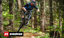
Video: Riding Some Of Whistler's Finest Singletrack
Jun 24, 2019 from pinkbike.com
Jason Lucas and Pete Matthews spent a day exploring three different networks around Whistler and share their first impressions.
Popular Cheakamus Dirtbiking Trails
| status | title | difficulty | rating |
|---|---|---|---|
| Cheakamus River Access Road |
Recent Ride Log Activity in Region
Today
- 0 dirtbike rides
Yesterday
- 0 dirtbike rides
Past Week
- 0 dirtbike rides
Photos of Cheakamus
trail: Lower Yer Saddle
318 |
Jun 7, 2017 @ 9:51pm
Jun 7, 2017
trail: Cheakamus Lake Trail
679 |
Aug 5, 2016 @ 8:21pm
Aug 5, 2016
trail: AM/PM
566 |
Jun 7, 2016 @ 7:39pm
Jun 7, 2016
trail: Cheakamus Lake Trail
497 |
Apr 28, 2016 @ 6:05pm
Apr 28, 2016
trail: High Side
415 |
Aug 9, 2015 @ 11:22pm
Aug 9, 2015
trail: High Side
639 |
Oct 25, 2014 @ 9:43am
Oct 25, 2014
trail: Lower Yer Saddle
627 |
Aug 24, 2014 @ 11:27pm
Aug 24, 2014
trail: Farside
510 | | 1 comments
May 1, 2011 @ 10:54pm
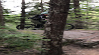
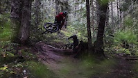
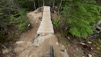
May 1, 2011Videos of Cheakamus

50 |
Jul 24, 2023
trail: Trash
|
Jul 24, 2023

trail: Trash
|
Jul 24, 2023
trail: AM/PM
7086 |
Nov 2, 2020

0:13 |
65 |
Jul 2, 2020
1:00 |
253 |
Aug 6, 2019
trail: Lower Yer Saddle
0:45 |
230 |
Aug 15, 2018
trail: Ridge (Hiking Only)
0:52 |
44 |
Jun 5, 2018
Recent Trail Reports
| status | trail | date | condition | info | user |
|---|---|---|---|---|---|
| Cheakamus River Access Road | Dec 15, 2022 @ 8:03pm Dec 15, 2022 | Snow Covered | jazzawil |
Activity Feed
| username | action | type | title | date |
|---|---|---|---|---|
| ronenns | add | report | activity #51030944 | Apr 10, 2024 @ 9:17pm Apr 10, 2024 |
| Justinboone1 | comment | trail | activity #44930498 | Oct 6, 2023 @ 2:04pm Oct 6, 2023 |
| kyleleitch | add | karma | activity #44450497 | Sep 23, 2023 @ 5:42pm Sep 23, 2023 |
| noelpullen | add | report | activity #43429023 and 1 more | Aug 27, 2023 @ 12:55pm Aug 27, 2023 |
| awaite | add | karma | activity #43203389 and 1 more | Aug 21, 2023 @ 8:00am Aug 21, 2023 |
Recent Comments
| username | type | title | comment | date |
|---|---|---|---|---|
| trail | Suspension bridge is up and great! | Oct 6, 2023 @ 2:04pm Oct 6, 2023 | ||
| report | October 1, 2022 Update: The river has been... | Oct 1, 2022 @ 8:42pm Oct 1, 2022 | ||
| report | Cuu t 6thf z | Jun 22, 2019 @ 1:41pm Jun 22, 2019 | ||
| report | yup took care of it this morning | Jun 15, 2019 @ 9:08pm Jun 15, 2019 | ||
| report | yeah, that's a my bad...lol...guess I'll make... | Oct 23, 2018 @ 10:23am Oct 23, 2018 |
Nearby Areas
| name | distance | ||||
|---|---|---|---|---|---|
| Tricouni Peak and Lake Area | 9.6 km | ||||
| Brohm Ridge | 1 | 15.7 km | |||
| South Rutherford | 6 | 2 | 2 | 3 | 16.2 km |
| Cat Lake | 1 | 3 | 17.7 km | ||
| Diamond Head | 4 | 41 | 32 | 11 | 21.6 km |
Activity Type Stats
| activitytype | trails | distance | descent | descent distance | total vertical | rating | global rank | state rank | photos | reports | routes | ridelogs |
|---|---|---|---|---|---|---|---|---|---|---|---|---|
| Mountain Bike | 82 | 54 miles | 12,949 ft | 25 miles | 1,916 ft | #133 | #27 | 943 | 2,553 | 13 | 26,385 | |
| E-Bike | 52 | 38 miles | 8,169 ft | 16 miles | 1,916 ft | #73 | #16 | 6 | 1,898 | 1 | 710 | |
| Hike | 86 | 53 miles | 13,504 ft | 25 miles | 1,916 ft | #81 | #18 | 51 | 2,536 | 1,804 | ||
| Trail Running | 86 | 53 miles | 13,504 ft | 25 miles | 1,916 ft | #80 | #18 | 7 | 2,536 | 3,345 | ||
| Dirtbike/Moto | 1 | 3 miles | 650 ft | 1 mile | 400 ft | 616 | 31 | |||||
| ATV/ORV/OHV | 1 | 3 miles | 650 ft | 1 mile | 400 ft | 616 | 7 | |||||
| Snowshoe | 1 | 3 miles | 587 ft | 1 mile | 299 ft | 4 | 6 |
- By brenthillier
 NSMBA TRAILFORKS & contributors
 - Admins: WORCA, RMOW, WNSC, ridingloam, snowdan, nkoshure, WORCA, TFerrao, dirtshifter, seb-kemp
- #14203 - 25,046 views
- cheakamus activity log | embed map of Cheakamus mountain bike trails | cheakamus mountain biking points of interest
Downloading of trail gps tracks in kml & gpx formats is enabled for Cheakamus.
You must login to download files.