close
-
Layers w
- Weather Layers
- Pro
- Pro
- Pro
- Pro
- Pro
- Pro
- More Layers
- Pro
- Pro
- Pro
- Pro
-
Upgrade to

3D
Trail Conditions
- Unknown
- Snow Groomed
- Snow Packed
- Snow Covered
- Snow Cover Partial
- Freeze/thaw Cycle
- Icy
- Prevalent Mud
- Wet
- Variable
- Ideal
- Dry
- Very Dry
Trail Flow (Ridden Direction)
Trailforks scans users ridelogs to determine the most popular direction each trail is ridden. A good flowing trail network will have most trails flowing in a single direction according to their intension.
The colour categories are based on what percentage of riders are riding a trail in its intended direction.
The colour categories are based on what percentage of riders are riding a trail in its intended direction.
- > 96%
- > 90%
- > 80%
- > 70%
- > 50%
- < 50%
- bi-directional trail
- no data
Trail Last Ridden
Trailforks scans ridelogs to determine the last time a trail was ridden.
- < 2 days
- < 1 week
- < 2 weeks
- < 1 month
- < 6 months
- > 6 months
Trail Ridden Direction
The intended direction a trail should be ridden.
- Downhill Only
- Downhill Primary
- Both Directions
- Uphill Primary
- Uphill Only
- One Direction
Contribute Details
Colors indicate trail is missing specified detail.
- Description
- Photos
- Description & Photos
- Videos
Trail Popularity ?
Trailforks scans ridelogs to determine which trails are ridden the most in the last 9 months.
Trails are compared with nearby trails in the same city region with a possible 25 colour shades.
Think of this as a heatmap, more rides = more kinetic energy = warmer colors.
- most popular
- popular
- less popular
- not popular
ATV/ORV/OHV Filter
Max Vehicle Width
inches
US Cell Coverage
Legend

Radar Time
Activity Recordings
Trailforks uses anonymized public activity data.
?
Activity Recordings
Trailforks uses anonymized public activity data.
?
Personal Heatmap
▶
Activity Types
all
/
none
▶
Options
2
Date range
month
–
Winter Trails
Warning
A routing network for winter maps does not exist. Selecting trails using the winter trails layer has been disabled.
Missing Trails
Most Popular
Least Popular
Trails are colored based on popularity. The more popular a trail is, the more red. Less popular trails trend towards green.
Jump Magnitude Heatmap
Heatmap of where riders jump on trails. Zoom in to see individual jumps, click circles to view jump details.
BC Backroad Status
![map legend]()
Service Road Atlas is a free to use, community-driven service for viewing and creating reports on the numerous back-country service roads around B.C. and Alberta.

Slope Aspect
Direction the slope faces
Trails Deemphasized
Trails are shown in grey.
Only show trails with no bike usage.
Suggested Layers
Based on selected activity type
Save the current map location and zoom level as your default home location whenever this page is loaded.
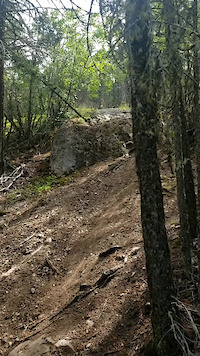
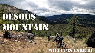
SaveDesous is a 1/2 hour drive west of the City and is home to some truly amazing free riding. Decents of 3500ft from the top of Desous Mountain all the way to the Fraser River make this home to some of the biggest lines this side of Golden. This area is intended for advanced riders, as there is no real easy way down. If you're looking for big lines, this is where it's at. Cell phone service is spotty in this area, so please ride safely.
Help support our trail network, purchase your Williams Lake Cycling Club membership here
Help support our trail network, purchase your Williams Lake Cycling Club membership here
source: http://ridethecariboo.ca/
Primary Trail Type: All-Mountain & Downhill
Shuttleable: YES
 google parking directions
 Region Supporters & Maintainers
![]()
Ride The CaribooMaintainer
Activities Click to view
- Mountain Bike
22 trails
- Hike
21 trails
- Trail Running
20 trails
Region Details
- 1
- 3
- 5
- 11
- 1
Region Status
Caution as of May 30, 2026Stats
- Avg Trail Rating
- Trails (view details)
- 21
- Trails Mountain Bike
- 22
- Trails E-Bike
- 2
- Trails Hike
- 21
- Trails Trail Running
- 20
- Total Distance
- 30 miles
- Total Descent
- 13,821 ft
- Total Vertical
- 2,859 ft
- Highest Trailhead
- 4,357 ft
- Reports
- 135
- Photos
- 146
- Ridden Counter
- 1,414
Popular Desous Mountain Biking Trails
• 80 ★ 4.7 • 3 miles • 27 ft • 243 •
= Soo Fun. This is an advanced downhill trail on the backside of which goes down to the Fraser river. If you are new to the area this is the first backside trail you will want to check out. This is a long flowy horse trail which follows...
• 75 ★ 5.0 • 5 miles • 2,306 ft • 176 •
Built in the Summer of 2017, this trail was funded by NDIT, and CBAC and created by First Journey Trails with the help from the Cariboo Mountain Bike Consortium. It was built as a bi-directional trail that would access the "backside" of...
• 80 ★ 0.0 • 1 mile • 634 ft • 161 •
Upper section of the new climbing trail .Once you cross forestry road you have zone of narrow machine built trail,It's a stiff climb but does last too long.As you get closer to the top it hand built again.This is a great ride blue skill...
• 65 ★ 4.7 • 2 miles • 0 ft • 146 •
Oosue has the some start and finish as the Classic. Oosue has a healthy rock drop, tons af jumps all lined up so you don't want to end, and a big cliff section everyone loves. The trail has an XC finish or rip to the cattle guard that's...
• 65 ★ 0.0 • 883 ft • 0 ft • 85 •
Short machine-built connector trail ,that allows rides to skip the black DH zones and flow around to easier sections of the frontside.Right onto OOsue, without using Lower .
• 60 ★ 4.7 • 3 miles • 22 ft • 74 •
is a must ride backside trail for Experts. It has everything, open then tight trees, flowy single track, wonderful views, dirt surfing, natural gap jumps of all and every size, and a loose open line that finishes in a marvelous rock...
• 60 ★ 5.0 • 2 miles • 3 ft • 73 •
Upper section of is an old school single track DH line, after crossing the Mountain Road, becomes a machine built jump trail with large tables, gaps, jumps and berms.2 optional road gaps @ crossings.
Desous Mountain Bike Routes
8 miles • 1,889 ft • 0 •
Preferred route leaving from the campsite to the top of the mountain with a long "Backside" descent and...
12 miles • 2,321 ft • 4 • Race •
2016 Osprey BC Enduro Series, presented by Smith, Round #3. Hosted by Red Shred's Bike and Board Shed,...
• 12 miles • 3,421 ft • 5 •
• 11 miles • 3,280 ft • 3 •
• 4 miles • 84 ft • 1 •
• 4 miles • 156 ft • 1 •
Photos of Desous Mountain Bike
Videos of Desous Mountain Bike


Recent Trail Reports
| status | trail | date | condition | info | user |
|---|---|---|---|---|---|
| A Keeper | May 30, 2026 @ 2:34pm (America/Vancouver) May 30, 2026 | Dry | fulty WLCC | ||
| Hotlaps | May 30, 2026 @ 2:34pm (America/Vancouver) May 30, 2026 | Dry | fulty WLCC | ||
| Smoke & Beers | May 30, 2026 @ 2:34pm (America/Vancouver) May 30, 2026 | Dry | fulty WLCC | ||
| Bulldozer | May 30, 2026 @ 2:34pm (America/Vancouver) May 30, 2026 | Dry | fulty WLCC | ||
| Prime & Endless | Nov 12, 2025 @ 7:13pm (America/Vancouver) Nov 12, 2025 | Ideal | theblackflash | ||
| Desous | Aug 10, 2025 @ 3:35pm Aug 10, 2025 | Unknown | poorman WLCC | ||
| Soo Long | Aug 3, 2025 @ 8:52am Aug 3, 2025 | Dry | DigX | ||
| Shiney Badger Upper Section | Aug 2, 2025 @ 8:54am Aug 2, 2025 | Ideal | mountainmaneuvers | ||
| Red Gate | Jun 21, 2025 @ 2:29pm Jun 21, 2025 | Ideal | poorman WLCC | ||
| Dirty Bunch Connector | Jun 21, 2025 @ 2:29pm Jun 21, 2025 | Ideal | poorman WLCC |
Activity Feed
| username | action | type | title | date |
|---|---|---|---|---|
| Archbagger | ridden | trail | activity #96716342 | Jun 10, 2026 @ 8:39pm Jun 10, 2026 |
| fulty | add | report | activity #95909266 and 3 more | May 30, 2026 @ 9:31pm May 30, 2026 |
| Vseland | wishlist | trail | activity #95500280 | May 25, 2026 @ 10:13am May 25, 2026 |
| Vseland | wishlist | region | activity #95499475 | May 25, 2026 @ 10:03am May 25, 2026 |
| JordanLJAzWv | wishlist | trail | activity #95089911 | May 19, 2026 @ 11:17pm May 19, 2026 |
Recent Comments
| username | type | title | comment | date |
|---|---|---|---|---|
| trail | This trail is just great free ride. There’s... | Aug 3, 2025 @ 8:57am Aug 3, 2025 | ||
| trail | Trees down all the way down if you keep going... | May 3, 2025 @ 5:26pm May 3, 2025 | ||
| trail | What an amazing hand built climb trail! Worth... | Aug 13, 2022 @ 10:56am Aug 13, 2022 | ||
| report | Nice! | May 27, 2021 @ 1:04pm May 27, 2021 | ||
| trail | Very fun but challenging descent down to... | Jul 29, 2019 @ 6:36pm Jul 29, 2019 |
Nearby Areas
| name | distance | ||||
|---|---|---|---|---|---|
| South Side | 1 | 28 | 8 | 10.1 km | |
| Westsyde | 12 | 25 | 13 | 1 | 10.5 km |
| Chimney Lake | 5 | 14 | 12.1 km | ||
| Fox Mountain | 13 | 26 | 15 | 3 | 12.5 km |
| Chief Will Yum | 1 | 2 | 1 | 14.2 km |
Local Badges
-

Completionist0 awarded
Local Mountain Biking Directory
-
Williams Lake Cycling Club
![Williams Lake Cycling Club]()
-
Fox Mountain Brewing Co.
-
Ride The CaribooTrail Association
![Ride The Cariboo]()
-
Red Shreds Bike & Board shedBike Shop
![Red Shreds Bike & Board shed]()
Activity Type Stats
| activitytype | trails | distance | descent | descent distance | total vertical | rating | global rank | state rank | photos | reports | routes | ridelogs |
|---|---|---|---|---|---|---|---|---|---|---|---|---|
| Mountain Bike | 22 | 30 miles | 13,822 ft | 18 miles | 2,858 ft | #3,669 | #164 | 140 | 135 | 2 | 791 | |
| E-Bike | 2 | 3,940 ft | 299 ft | 3,862 ft | 295 ft | 60 | 15 | |||||
| Hike | 21 | 29 miles | 13,632 ft | 18 miles | 2,858 ft | #6,458 | #262 | 6 | 132 | 82 | ||
| Trail Running | 20 | 29 miles | 13,337 ft | 17 miles | 2,858 ft | #5,769 | #206 | 131 | 2 |
Frequently Asked Questions About Desous
▼
What are the highest rated mountain biking trails in Desous?
The highest rated mountain biking trails in Desous are:
- Soo Long (4.5/5)
- Red Gate (4.4/5)
- Prime & Endless (4.4/5)
- OOsous (4.4/5)
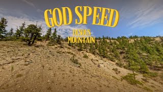
- God Speed (4.3/5)
▼
What is the best time of the year to ride in Desous?
Based on ride log data, the most popular months to ride in Desous are:
- July (24 activities)
- May (16 activities)
- August (16 activities)
▼
Where can I park to ride in Desous?
There are 3 parking locations listed in Desous. The most popular parking spots are: View all parking and trailhead locations on the map to plan your visit.
▼
What is the longest trail in Desous?
The longest trail in Desous is Shiney Badger at 8.2 km. View all trails sorted by distance.
Trails
Points of Interest
- By brenthillier
 NSMBA TRAILFORKS & contributors
 - Admins: CMBC, WLCC, RSTBC
- #3332 - 8,764 views
- desous activity log | embed map of Desous mountain bike trails | desous mountain biking points of interest
Downloading of trail gps tracks in kml & gpx formats is enabled for Desous.
You must login to download files.