close
-
Layers w
- Weather Layers
- Pro
- Pro
- Pro
- Pro
- Pro
- Pro
- More Layers
- Pro
- Pro
- Pro
- Pro
-
Upgrade to

3D
Trail Conditions
- Unknown
- Snow Groomed
- Snow Packed
- Snow Covered
- Snow Cover Partial
- Freeze/thaw Cycle
- Icy
- Prevalent Mud
- Wet
- Variable
- Ideal
- Dry
- Very Dry
Trail Flow (Ridden Direction)
Trailforks scans users ridelogs to determine the most popular direction each trail is ridden. A good flowing trail network will have most trails flowing in a single direction according to their intension.
The colour categories are based on what percentage of riders are riding a trail in its intended direction.
The colour categories are based on what percentage of riders are riding a trail in its intended direction.
- > 96%
- > 90%
- > 80%
- > 70%
- > 50%
- < 50%
- bi-directional trail
- no data
Trail Last Ridden
Trailforks scans ridelogs to determine the last time a trail was ridden.
- < 2 days
- < 1 week
- < 2 weeks
- < 1 month
- < 6 months
- > 6 months
Trail Ridden Direction
The intended direction a trail should be ridden.
- Downhill Only
- Downhill Primary
- Both Directions
- Uphill Primary
- Uphill Only
- One Direction
Contribute Details
Colors indicate trail is missing specified detail.
- Description
- Photos
- Description & Photos
- Videos
Trail Popularity ?
Trailforks scans ridelogs to determine which trails are ridden the most in the last 9 months.
Trails are compared with nearby trails in the same city region with a possible 25 colour shades.
Think of this as a heatmap, more rides = more kinetic energy = warmer colors.
- most popular
- popular
- less popular
- not popular
ATV/ORV/OHV Filter
Max Vehicle Width
inches
US Cell Coverage
Legend

Radar Time
Activity Recordings
Trailforks uses anonymized public activity data.
?
Activity Recordings
Trailforks uses anonymized public activity data.
?
Personal Heatmap
▶
Activity Types
all
/
none
▶
Options
2
Date range
month
–
Winter Trails
Warning
A routing network for winter maps does not exist. Selecting trails using the winter trails layer has been disabled.
Missing Trails
Most Popular
Least Popular
Trails are colored based on popularity. The more popular a trail is, the more red. Less popular trails trend towards green.
Jump Magnitude Heatmap
Heatmap of where riders jump on trails. Zoom in to see individual jumps, click circles to view jump details.
BC Backroad Status
![map legend]()
Service Road Atlas is a free to use, community-driven service for viewing and creating reports on the numerous back-country service roads around B.C. and Alberta.

Slope Aspect
Direction the slope faces
Trails Deemphasized
Trails are shown in grey.
Only show trails with no bike usage.
Suggested Layers
Based on selected activity type
Save the current map location and zoom level as your default home location whenever this page is loaded.
Save
No description for Globe has been added yet!
Login or register to submit one.
Activities Click to view
- Mountain Bike
40 trails
- E-Bike
10 trails
- Gravel Bike
3 trails
- Adaptive Bike
2 trails
- Horse
28 trails
- Hike
40 trails
- Trail Running
39 trails
- Dirtbike/Moto
13 trails
- ATV/ORV/OHV
13 trails
Region Details
- 16
- 4
- 7
- 7
- 1
Region Status
Open as of Jun 14, 2026E-Bike Stats
- Global Ranking
- #5,245
- State Ranking
- #1,631
- Trails (view details)
- 10
- Trails Mountain Bike
- 40
- Trails E-Bike
- 10
- Trails Gravel Bike
- 3
- Trails Adaptive Bike
- 2
- Trails Horse
- 28
- Trails Hike
- 40
- Trails Trail Running
- 39
- Trails Dirtbike/Moto
- 13
- Trails Observed Trials
- 1
- Trails ATV/ORV/OHV
- 13
- Trails Snowmobile
- 1
- Trails Snowshoe
- 1
- Trails Backcountry Ski
- 1
- Trails Nordic Ski
- 1
- Total Distance
- 21 miles
- Total Descent Distance
- 13 miles
- Total Descent
- 3,232 ft
- Total Vertical
- 1,877 ft
- Reports
- 41
- Ridden Counter
- 150
Sub Regions
-
Pinal Mountain Trail System
- 4
- 7
- 7
- 1
Globe Routes
11 miles • 999 ft • 0 • Loop •
11 mile loop to see some very pretty country. Open to all types of travel, camping is dispersed if you...
Photos of Globe
Videos of Globe
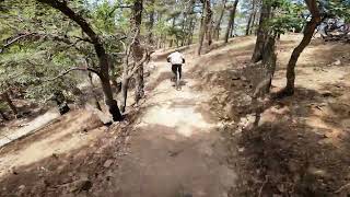
trail: Six Shooter Trail
0:10 |
190 |
Jan 28, 2021
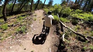
trail: Six Shooter Trail
0:00 |
417 |
Aug 8, 2019
trail: Kellner Canyon Trail
7:34 |
358 |
Jan 16, 2018
trail: Pinal Vista Loop (Southside)
5:30 |
36 |
May 25, 2026 , Globe
trail: Pinal Vista Loop (Northside)
3:07 |
28 |
May 25, 2026 , Globe
trail: Pinal Vista Loop (Southside)
4:28 |
34 |
May 25, 2026 , Globe
trail: Six Shooter Trail
17:45 |
68 |
May 16, 2026 , Globe
trail: Pinal Vista Loop (Southside)
4:45 |
108 |
Mar 8, 2026 , Globe
Recent Trail Reports
| status | trail | date | condition | info | user |
|---|---|---|---|---|---|
| GWT - Ice House Canyon Road | Nov 23, 2024 @ 2:30pm Nov 23, 2024 | Dry | highdesertman | ||
| Pinal Mtn. Rd. | May 19, 2022 @ 8:50pm May 19, 2022 | Dry | RockinronnieF |
Activity Feed
| username | action | type | title | date |
|---|---|---|---|---|
| Sheepdog590 | add | photo | activity #98159283 and 1 more | Jun 30, 2026 @ 3:23pm 2 days |
| 7SQTCwWN | wishlist | region | activity #97829488 | Jun 26, 2026 @ 6:21am Jun 26, 2026 |
| clkwrk | add | video | activity #95523174 and 1 more | May 25, 2026 @ 2:21pm May 25, 2026 |
| clkwrk | add | video | activity #95497514 | May 25, 2026 @ 9:41am May 25, 2026 |
| Neonguy25 | add | video | activity #94874114 | May 16, 2026 @ 10:43pm May 16, 2026 |
Recent Comments
| username | type | title | comment | date |
|---|---|---|---|---|
| report | There is many trees down as indicated by my... | Mar 30, 2025 @ 4:54pm Mar 30, 2025 | ||
| report | Thanks. Did you move that small tree thats... | Mar 30, 2025 @ 4:50pm Mar 30, 2025 | ||
| report | Awesome trail | Mar 29, 2025 @ 8:30pm Mar 29, 2025 | ||
| report | your report is for the trail not this paved... | Feb 18, 2025 @ 6:00am Feb 18, 2025 | ||
| report | Your report is for the icehouse trail not this... | Feb 18, 2025 @ 5:59am Feb 18, 2025 |
Activity Type Stats
| activitytype | trails | distance | descent | descent distance | total vertical | rating | global rank | state rank | photos | reports | routes | ridelogs |
|---|---|---|---|---|---|---|---|---|---|---|---|---|
| Mountain Bike | 40 | 86 miles | 24,098 ft | 52 miles | 5,351 ft | #3,498 | #1,196 | 567 | 259 | 15 | 1,781 | |
| E-Bike | 10 | 21 miles | 3,232 ft | 13 miles | 1,877 ft | #5,245 | #1,631 | 41 | 1 | 120 | ||
| Gravel Bike | 3 | #730 | #1,189 | 1 | 1 | 1 | ||||||
| Adaptive Bike | 2 | #710 | #1,907 | 2 | ||||||||
| Horse | 28 | 54 miles | 17,822 ft | 31 miles | 3,455 ft | #1,072 | #695 | 178 | 1 | |||
| Hike | 40 | 88 miles | 23,543 ft | 50 miles | 5,351 ft | #3,321 | #1,170 | 263 | 2 | 326 | ||
| Trail Running | 39 | 83 miles | 23,383 ft | 49 miles | 5,351 ft | #2,961 | #861 | 263 | 2 | 12 | ||
| Dirtbike/Moto | 13 | 28 miles | 3,625 ft | 13 miles | 4,213 ft | #841 | #304 | 15 | 1 | 4 | ||
| Observed Trials | 1 | 1 | ||||||||||
| ATV/ORV/OHV | 13 | 28 miles | 3,625 ft | 13 miles | 4,213 ft | #599 | #232 | 15 | 1 | 2 | ||
| Snowmobile | 1 | |||||||||||
| Snowshoe | 1 | 1 | ||||||||||
| Backcountry Ski | 1 | |||||||||||
| Nordic Ski | 1 |
Frequently Asked Questions About Globe
▼
What are the best places to ride in Globe?
Globe has 1 areas to explore for e-biking. The top rated areas are:
▼
What is the best time of the year to ride in Globe?
Based on ride log data, the most popular months to ride in Globe are:
- December (4 activities)
▼
Where can I park to ride in Globe?
There are 3 parking locations listed in Globe. The most popular parking spots are: View all parking and trailhead locations on the map to plan your visit.
▼
What are the best & highest rated hiking trails in Globe?
The best hiking trails in Globe are:
- Six Shooter Trail
- Haunted Canyon Trail
- Lower Six Shooter Trail
- Lower Telephone Trail
- East Mountain Trail
Activities
Trails
Points of Interest
- Cibeque Falls Sight
- Second Campground Camping
- Salt Bank Campground Camping
- Ladder Rock (view point) Viewpoint
- Pinal and Upper Pinal Campground Camping
- Big expansive south views Viewpoint
- Sunset Viewpoint
- Views Viewpoint
- Views into Globe Viewpoint
- Pinal Mountains (7,838 ft)
- Pinal Peak (7,838 ft)
- Signal Peak (7,812 ft)
- By schillingsworth
 TRAILFORKS HTA & contributors
 - Admins: AZT, chainslapAZ, schillingsworth, jeffgicklhorn, jpmcghee, msmcfate, cemoorelife, Schwinnshralper26
- #6019 - 9,862 views
- globe activity log | embed map of Globe mountain bike trails | globe mountain biking points of interest
Downloading of trail gps tracks in kml & gpx formats is enabled for Globe.
You must login to download files.