close
-
Layers w
- Weather Layers
- Pro
- Pro
- Pro
- Pro
- Pro
- Pro
- More Layers
- Pro
- Pro
- Pro
- Pro
-
Upgrade to

3D
Trail Conditions
- Unknown
- Snow Groomed
- Snow Packed
- Snow Covered
- Snow Cover Partial
- Freeze/thaw Cycle
- Icy
- Prevalent Mud
- Wet
- Variable
- Ideal
- Dry
- Very Dry
Trail Flow (Ridden Direction)
Trailforks scans users ridelogs to determine the most popular direction each trail is ridden. A good flowing trail network will have most trails flowing in a single direction according to their intension.
The colour categories are based on what percentage of riders are riding a trail in its intended direction.
The colour categories are based on what percentage of riders are riding a trail in its intended direction.
- > 96%
- > 90%
- > 80%
- > 70%
- > 50%
- < 50%
- bi-directional trail
- no data
Trail Last Ridden
Trailforks scans ridelogs to determine the last time a trail was ridden.
- < 2 days
- < 1 week
- < 2 weeks
- < 1 month
- < 6 months
- > 6 months
Trail Ridden Direction
The intended direction a trail should be ridden.
- Downhill Only
- Downhill Primary
- Both Directions
- Uphill Primary
- Uphill Only
- One Direction
Contribute Details
Colors indicate trail is missing specified detail.
- Description
- Photos
- Description & Photos
- Videos
Trail Popularity ?
Trailforks scans ridelogs to determine which trails are ridden the most in the last 9 months.
Trails are compared with nearby trails in the same city region with a possible 25 colour shades.
Think of this as a heatmap, more rides = more kinetic energy = warmer colors.
- most popular
- popular
- less popular
- not popular
ATV/ORV/OHV Filter
Max Vehicle Width
inches
US Cell Coverage
Legend

Radar Time
Activity Recordings
Trailforks uses anonymized public activity data.
?
Activity Recordings
Trailforks uses anonymized public activity data.
?
Personal Heatmap
▶
Activity Types
all
/
none
▶
Options
2
Date range
month
–
Winter Trails
Warning
A routing network for winter maps does not exist. Selecting trails using the winter trails layer has been disabled.
Missing Trails
Most Popular
Least Popular
Trails are colored based on popularity. The more popular a trail is, the more red. Less popular trails trend towards green.
Jump Magnitude Heatmap
Heatmap of where riders jump on trails. Zoom in to see individual jumps, click circles to view jump details.
BC Backroad Status
![map legend]()
Service Road Atlas is a free to use, community-driven service for viewing and creating reports on the numerous back-country service roads around B.C. and Alberta.

Slope Aspect
Direction the slope faces
Trails Deemphasized
Trails are shown in grey.
Only show trails with no bike usage.
Suggested Layers
Based on selected activity type
Save the current map location and zoom level as your default home location whenever this page is loaded.
SaveThis is one of the primary dirtbike trail areas in Squamish.
The Squamish Dirt Bike Association performs an amazing service building and maintaining this popular trail network. They rely entirely on your membership to keep this service running. Please show your support by becoming a member.
The Squamish Dirt Bike Association performs an amazing service building and maintaining this popular trail network. They rely entirely on your membership to keep this service running. Please show your support by becoming a member.
Primary Trail Type: Cross-Country
eBikes Allowed:
Yes
AKA: Lava Flow
Land Status: Crown Land
 google parking directions
 Disclaimer:
For visitors to this area, it would be greatly appreciated if you can make a small donation to the SDBA using the Trailforks Trail Karma.
Links
Activities Click to view
- Dirtbike/Moto
99 trails
- Mountain Bike
27 trails
- E-Bike
29 trails
- Hike
20 trails
- Trail Running
23 trails
- Observed Trials
21 trails
- ATV/ORV/OHV
9 trails
Region Details
- 13
- 1
- 5
- 7
- 1
Region Status
Open as of 22 hoursStats
- Avg Trail Rating
- Trails (view details)
- 110
- Trails Mountain Bike
- 27
- Trails E-Bike
- 29
- Trails Gravel Bike
- 8
- Trails Adaptive Bike
- 2
- Trails Hike
- 20
- Trails Trail Running
- 23
- Trails Dirtbike/Moto
- 99
- Trails Observed Trials
- 21
- Trails ATV/ORV/OHV
- 9
- Total Distance
- 76 miles
- Total Descent Distance
- 27 miles
- Total Descent
- 11,547 ft
- Total Vertical
- 2,893 ft
- Highest Trailhead
- 3,138 ft
- Reports
- 2,353
- Photos
- 933
- Ridden Counter
- 30,625
Popular Lava Flow Mountain Biking Trails
• 95 ★ 4.4 • 2,457 ft • 0 ft • 4,776 •
A fun flow trail similar to , taking riders from the bottom of to the bridge. A high-speed trail with some berms & small table top jumps. Continue across the river & head towards , Powerhoods, , & .
• 90 ★ 3.0 • 892 ft • 0 ft • 3,479 •
A great connector to and . Popular in bike races.
• 80 ★ 4.9 • 1 mile • 83 ft • 3,006 •
Pretty much incorporates the best of squamish minus the machine-built flow. This hand-built trail is a masterpiece, a labour of love, and a great all-round ride. Rock slabs, bridges, flowy loam... it's all there. The access climb gets...
• 80 ★ 3.9 • 1,788 ft • 12 ft • 2,613 •
Fool’s Gold starts from the and ends at the Darwin’s and the start of the Panda Climb. This trail is good for riders of all abilities and is a good way to connect into Another Man’s Gold down to Darwin’s Bridge. This trail was...
• 80 ★ 4.2 • 1,280 ft • 0 ft • 2,517 •
A slightly harder, but all downhill, alternate exit for . Hard rock lines are the theme of this trail.
• 85 ★ 4.7 • 2,703 ft • 17 ft • 2,419 •
"We should build a jump trail" -heard in the OneUp HQ, Sept 2017 following a lunch ride devoid of jumps. This trail was applied for and built by the team at OneUp Components, with help from many other community volunteers from 2018-2022...
• 85 ★ 3.0 • 1,870 ft • 18 ft • 2,403 • • moto
If you're heading to / , this is the half of you want to take. Begins by continuing straight at the intersection of /Hoods
• 80 ★ 2.5 • 2,740 ft • 6 ft • 2,217 •
An easy continuation from the end of Hoods with some nice views once you emerge from the trees.
Lava Flow Mountain Bike Routes
8 miles • 1,570 ft • 8 •
**COURSE IS SUBJECT TO CHANGE AND FINAL COURSES WILL BE ANNOUNCED AT COACH'S MEETING ON MAY 22, 2024** XC...
5 miles • 722 ft • 5 •
**COURSE IS SUBJECT TO CHANGE AND FINAL COURSES WILL BE ANNOUNCED AT COACH'S MEETING ON MAY 22, 2024** XC...
19 miles • 4,084 ft • 20 •
Proposed ride for Diamond head area for Quest alumni group ride. The ride can be shortened if necessary or...
7 miles • 2,085 ft • 7 •
cakewalk -> up FN road climb to gerbil track -> middle ditch pig -> up FN climb trail ->...
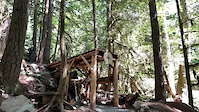
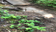
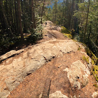
Photos of Lava Flow Mountain Bike
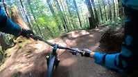
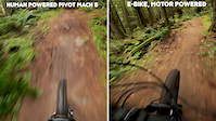
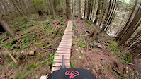
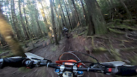
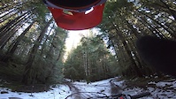
Videos of Lava Flow Mountain Bike
trail: Airplane Mode
0:05 |
918 |
Aug 7, 2022
trail: Airplane Mode
0:11 |
448 |
Jul 29, 2022
trail: Somewhere Over There
0:18 |
282 |
Jul 19, 2021
trail: Somewhere Over There
4:01 |
93 |
Apr 7, 2021
trail: Another Man's Gold
2:16 |
540 |
Nov 27, 2019
trail: Another Man's Gold
0:53 |
72 |
Apr 11, 2019
trail: KinADay
4:32 |
468 |
Feb 6, 2019
trail: Highball
3:39 |
459 |
Jan 28, 2019
Current Trail Warnings
| status | trail | date | condition | user | info |
|---|---|---|---|---|---|
| Powerhouse Plunge | Jul 6, 2026 @ 2:41pm (America/Vancouver) 22 hours | Ideal | SORCA SORCA | Aggressive bear in the area. Trail... |
Recent Trail Reports
| status | trail | date | condition | info | user |
|---|---|---|---|---|---|
| Green Spider | Jun 24, 2026 @ 7:48am (Pacific/Midway) Jun 24, 2026 | Ideal | jburbee | ||
| Somewhere Over There | Jun 24, 2026 @ 7:48am (Pacific/Midway) Jun 24, 2026 | Ideal | jburbee | ||
| Bonsai North | Jun 24, 2026 @ 7:48am (Pacific/Midway) Jun 24, 2026 | Ideal | jburbee | ||
| Hoods Connector | Jun 24, 2026 @ 7:48am (Pacific/Midway) Jun 24, 2026 | Ideal | jburbee | ||
| Blindside Connector | Jun 24, 2026 @ 7:48am (Pacific/Midway) Jun 24, 2026 | Ideal | jburbee | ||
| Carpenter's Son Alternate Access | Jun 1, 2026 @ 6:08pm (America/Vancouver) Jun 1, 2026 | Ideal | Downhilljill61 | ||
| Poop Alley | May 31, 2026 @ 11:12am (America/Vancouver) May 31, 2026 | Ideal | julievdh | ||
| Another Man's Gold | May 31, 2026 @ 9:31am (America/Vancouver) May 31, 2026 | Ideal | awhite76 | ||
| LFW | May 28, 2026 @ 2:15pm (America/Vancouver) May 28, 2026 | Ideal | sofakingdom | ||
| Power House Plunge - Access | May 28, 2026 @ 2:15pm (America/Vancouver) May 28, 2026 | Ideal | sofakingdom |
Activity Feed
| username | action | type | title | date |
|---|---|---|---|---|
| cameron-lv | wishlist | route | activity #98641972 | Jul 7, 2026 @ 7:59am 5 hours |
| EnduroCX | wishlist | trail | activity #98621773 | Jul 6, 2026 @ 11:32pm 13 hours |
| SORCA | add | report | activity #98599646 | Jul 6, 2026 @ 2:41pm 22 hours |
| annabel7 | wishlist | trail | activity #98557641 and 2 more | Jul 5, 2026 @ 11:37pm 2 days |
| Joy-rider | wishlist | trail | activity #98470019 | Jul 4, 2026 @ 8:17pm 3 days |
Recent Comments
| username | type | title | comment | date |
|---|---|---|---|---|
| trail | 99% hike-a-bike. There was also a full RV camp... | Jun 25, 2026 @ 11:40am Jun 25, 2026 | ||
| trail | I road the Mamquam up and connected into this... | Jun 25, 2026 @ 11:39am Jun 25, 2026 | ||
| trail | well it used to be pedalable... can't say it... | Jun 24, 2026 @ 10:35pm Jun 24, 2026 | ||
| trail | The trail is in a really odd shape right now.... | Jun 24, 2026 @ 10:14pm Jun 24, 2026 | ||
| trail | @liamdubs…glad you got a chance to ride it.... | May 5, 2026 @ 11:06am May 5, 2026 |
Nearby Areas
| name | distance | ||||
|---|---|---|---|---|---|
| Diamond Head | 4 | 40 | 31 | 12 | 2.2 km |
| Valleycliffe | 9 | 30 | 23 | 10 | 3.4 km |
| Smoke Bluffs Park | 1 | 3 | 1 | 4.5 km | |
| Alice Lake & Highlands | 14 | 46 | 47 | 20 | 4.9 km |
| Brackendale | 42 | 1 | 5.6 km |
Local Badges
-

Completionist1 awarded
Activity Type Stats
| activitytype | trails | distance | descent | descent distance | total vertical | rating | global rank | state rank | photos | reports | routes | ridelogs |
|---|---|---|---|---|---|---|---|---|---|---|---|---|
| Mountain Bike | 27 | 35 miles | 5,377 ft | 12 miles | 2,894 ft | #545 | #57 | 613 | 2,265 | 22 | 3,603 | |
| E-Bike | 29 | 36 miles | 5,610 ft | 12 miles | 2,894 ft | #761 | #38 | 4 | 2,207 | 416 | ||
| Gravel Bike | 8 | 9 miles | 873 ft | 3 miles | 1,640 ft | #1,076 | #113 | 5 | 430 | 22 | ||
| Adaptive Bike | 2 | 1 mile | 269 ft | 3,783 ft | 712 ft | #1,078 | #113 | 188 | 1 | |||
| Hike | 20 | 31 miles | 2,306 ft | 8 miles | 2,894 ft | #5,971 | #246 | 4 | 2,041 | 511 | ||
| Trail Running | 23 | 33 miles | 4,639 ft | 11 miles | 2,894 ft | #3,558 | 2 | 2,112 | 1 | 1,047 | ||
| Dirtbike/Moto | 99 | 70 miles | 7,789 ft | 22 miles | 2,894 ft | #10 | #9 | 292 | 1,223 | 4 | 1,857 | |
| Observed Trials | 21 | 18 miles | 1,736 ft | 6 miles | 1,801 ft | #8 | #4 | 11 | 65 | 31 | ||
| ATV/ORV/OHV | 9 | 19 miles | 879 ft | 5 miles | 2,493 ft | #379 | #34 | 572 | 6 |
Frequently Asked Questions About Lava Flow
▼
What are the highest rated mountain biking trails in Lava Flow?
The highest rated mountain biking trails in Lava Flow are:
- Somewhere Over There (4.8/5)
- Airplane Mode (4.5/5)
- Unrelated Dead Guys (4.5/5)
- Another Man's Gold (4.3/5)
- Green Spider (4.2/5)
▼
What is the best time of the year to ride in Lava Flow?
Based on ride log data, the most popular months to ride in Lava Flow are:
- July (57 activities)
- June (41 activities)
- April (35 activities)
▼
Where can I park to ride in Lava Flow?
There are 2 parking locations listed in Lava Flow. The most popular parking spots are:
▼
What is the longest trail in Lava Flow?
The longest trail in Lava Flow is Ring Creek Rip at 3.0 km. View all trails sorted by distance.
Activities
Trails
- By Sun2306
 & contributors
 - Admins: SORCA, SDBA, vincer, james529529, bigredted, CruJonze, dmpb, B2H4me, bcorigin, Brennwills
- #19698 - 14,572 views
- lava flow activity log | embed map of Lava Flow mountain bike trails | lava flow mountain biking points of interest polygons
Downloading of trail gps tracks in kml & gpx formats is enabled for Lava Flow.
You must login to download files.