close
-
Layers w
- Weather Layers
- Pro
- Pro
- Pro
- Pro
- Pro
- Pro
- More Layers
- Pro
- Pro
- Pro
- Pro
-
Upgrade to

3D
Trail Conditions
- Unknown
- Snow Groomed
- Snow Packed
- Snow Covered
- Snow Cover Partial
- Freeze/thaw Cycle
- Icy
- Prevalent Mud
- Wet
- Variable
- Ideal
- Dry
- Very Dry
Trail Flow (Ridden Direction)
Trailforks scans users ridelogs to determine the most popular direction each trail is ridden. A good flowing trail network will have most trails flowing in a single direction according to their intension.
The colour categories are based on what percentage of riders are riding a trail in its intended direction.
The colour categories are based on what percentage of riders are riding a trail in its intended direction.
- > 96%
- > 90%
- > 80%
- > 70%
- > 50%
- < 50%
- bi-directional trail
- no data
Trail Last Ridden
Trailforks scans ridelogs to determine the last time a trail was ridden.
- < 2 days
- < 1 week
- < 2 weeks
- < 1 month
- < 6 months
- > 6 months
Trail Ridden Direction
The intended direction a trail should be ridden.
- Downhill Only
- Downhill Primary
- Both Directions
- Uphill Primary
- Uphill Only
- One Direction
Contribute Details
Colors indicate trail is missing specified detail.
- Description
- Photos
- Description & Photos
- Videos
Trail Popularity ?
Trailforks scans ridelogs to determine which trails are ridden the most in the last 9 months.
Trails are compared with nearby trails in the same city region with a possible 25 colour shades.
Think of this as a heatmap, more rides = more kinetic energy = warmer colors.
- most popular
- popular
- less popular
- not popular
ATV/ORV/OHV Filter
Max Vehicle Width
inches
US Cell Coverage
Legend

Radar Time
Activity Recordings
Trailforks uses anonymized public activity data.
?
Activity Recordings
Trailforks uses anonymized public activity data.
?
Personal Heatmap
▶
Activity Types
all
/
none
▶
Options
2
Date range
month
–
Winter Trails
Warning
A routing network for winter maps does not exist. Selecting trails using the winter trails layer has been disabled.
Missing Trails
Most Popular
Least Popular
Trails are colored based on popularity. The more popular a trail is, the more red. Less popular trails trend towards green.
Jump Magnitude Heatmap
Heatmap of where riders jump on trails. Zoom in to see individual jumps, click circles to view jump details.
BC Backroad Status
![map legend]()
Service Road Atlas is a free to use, community-driven service for viewing and creating reports on the numerous back-country service roads around B.C. and Alberta.

Slope Aspect
Direction the slope faces
Trails Deemphasized
Trails are shown in grey.
Only show trails with no bike usage.
Suggested Layers
Based on selected activity type
Save the current map location and zoom level as your default home location whenever this page is loaded.
SaveThis region is Unsanctioned, Ride at your own Risk!
THIS NETWORK IS UNSANCTIONED. RIDE AT YOUR OWN RISK.
The land on which these trails are built is owned by several different private property owners and if you use these trails you may be considered to be trespassing.
The land on which these trails are built is owned by several different private property owners and if you use these trails you may be considered to be trespassing.
Primary Trail Type: All-Mountain & Downhill
eBikes Allowed:
Yes
AKA: Mckee Peak
Land Status: Private Property
 google parking directions
 Activities Click to view
- Mountain Bike
121 trails
- E-Bike
9 trails
- Hike
104 trails
- Trail Running
105 trails
Region Details
- 24
- 2
- 23
- 40
- 25
- 7
Region Status
Open as of 3 daysStats
- Avg Trail Rating
- Trails (view details)
- 121
- Trails Mountain Bike
- 123
- Trails E-Bike
- 9
- Trails Hike
- 104
- Trails Trail Running
- 105
- Total Distance
- 38 miles
- Total Descent
- 16,349 ft
- Total Vertical
- 1,496 ft
- Highest Trailhead
- 1,525 ft
- Reports
- 7,196
- Photos
- 2,210
- Ridden Counter
- 51,488
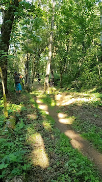
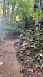
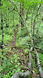
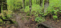
Popular Ledgeview Mountain Biking Trails
• 100 ★ 3.8 • 656 ft • 67 ft • 1,040 •
The final section of climbing single track from the North/West sides ("Tree Farm" hill grind not withstanding)
• 95 ★ 4.2 • 2,087 ft • 0 ft • 1,031 •
A few berms and mid-size jumps (jumps are black/gaps , but have good ride-arounds) at the beginning, then feed into some tighter, twisty single track with a couple more smallish jumps/drops along the way. An alternative to Lower Daplow.
• 100 ★ 4.0 • 679 ft • 42 ft • 983 •
A connector to allow for complete single track climbing from both parking areas up to the "tree farm"
• 95 ★ 4.4 • 3,451 ft • 55 ft • 977 •
Some of the stunts on this trail are double black, but can easily be ridden as a blue trail. All jumps are gaps, so look before you leap.
• 100 ★ 4.5 • 1,785 ft • 180 ft • 954 •
Built as an Up trail, but downhill friendly.
• 100 ★ 3.5 • 1,109 ft • 0 ft • 861 •
Easiest way down from the tower (excluding the climb).
• 95 ★ 4.5 • 1,132 ft • 0 ft • 857 •
Top half is a small-mid sized jump line with a ladder drop/step down. Second bit is the newer tree farm below the ridge with a rolling benchcut.
• 100 ★ 4.7 • 1,742 ft • 202 ft • 816 •
A direct extension to Total Sanity (Beginning). While also climb primary but not closed to downhill traffic, the tighter switchback corners will limit speed in that direction. There is one very short, but mandatory skinny immediately...
Ledgeview Mountain Bike Routes
★ 5.0 • 10 miles • 2,480 ft • 10 •
Fraser Valley Ledgeview Epic Fraser Valley Relive Your Rides For other ride suggestions for this and other...
★ 2.0 • 9 miles • 2,596 ft • 19 •
Fraser Valley Ledgeview Classic Fraser Valley Relive Your Ride For other ride suggestions for this and...
★ 5.0 • 3 miles • 706 ft • 7 • Point to Point •
Fun loop. Trails that are involved in the loop: - Viper - Mamba - Paper Route - Amy Fisher - Spin Cycle -...
8 miles • 2,204 ft • 13 • Loop •
A mix of new and old dh flow/fr trails and access rd/single track climbs. The descents can all be ridden...
4 miles • 1,213 ft • 12 •
Fraser Valley Ledgeview Quickie Fraser Valley Relive Your Ride For other ride suggestions for this and...
10 miles • 2,462 ft • 10 •
Fraser Valley Ledgeview Epic Fraser Valley Relive Your Rides For other ride suggestions for this and other...
Photos of Ledgeview Mountain Bike
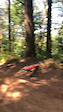
Videos of Ledgeview Mountain Bike

trail: Noodley Appendage
0:08 |
62 |
Aug 29, 2024
trail: Noodley Appendage
0:08 |
38 |
Aug 29, 2024
trail: Paper Route
0:13 |
164 |
Sep 25, 2022
trail: Paper Route
0:10 |
97 |
Dec 31, 2021
trail: Guava Jelly
0:13 |
148 |
Oct 16, 2021
trail: Da Plow
0:20 |
178 |
May 9, 2021
trail: Berm Donor
0:11 |
208 |
Apr 6, 2021
trail: Da Plow
0:04 |
275 |
Sep 30, 2020
Recent Trail Reports
Activity Feed
| username | action | type | title | date |
|---|---|---|---|---|
| ElvisMeatface | add | trail | activity #97692149 | Jun 24, 2026 @ 6:18am 2 hours |
| valko206 | wishlist | route | activity #97300731 | Jun 19, 2026 @ 12:19am Jun 19, 2026 |
| ryanharris12 | add | report | activity #97157849 | Jun 16, 2026 @ 7:45pm Jun 16, 2026 |
| Julieagnesg | wishlist | trail | activity #97105907 | Jun 16, 2026 @ 6:42am Jun 16, 2026 |
| dokk | add | report | activity #96845349 and 9 more | Jun 12, 2026 @ 8:02pm Jun 12, 2026 |
Recent Comments
| username | type | title | comment | date |
|---|---|---|---|---|
| trail | Tree branch down, fully blocking About 100m... | Jun 2, 2026 @ 12:54am Jun 2, 2026 | ||
| trail | Closed due to development | Apr 10, 2026 @ 4:15pm Apr 10, 2026 | ||
| trail | Closed due to development | Apr 10, 2026 @ 4:14pm Apr 10, 2026 | ||
| trail | Incorrectly labeled as Charlie's Canned... | Feb 11, 2026 @ 7:38pm Feb 11, 2026 | ||
| report | The tree is down at the second decent from the... | Feb 6, 2026 @ 10:26am Feb 6, 2026 |
Nearby Areas
| name | distance | ||||
|---|---|---|---|---|---|
| Sumas Mountain | 13 | 9 | 4.2 km | ||
| Downes Bowl / McLure Hillside | 11 | 4 | 4.7 km | ||
| The Great Trail / Matsqui Dyke | 5.7 km | ||||
| Heritage Trails | 10 | 6 | 8 | 6.1 km | |
| Bear Mountain | 6 | 25 | 8 | 8.9 km |
Local Badges
-

Completionist6 awarded
Local Mountain Biking Directory
-
Abby Bike Shop
-
LifecyclesBike Shop
-
Canadian Bike SupplyBike Shop
Local Products
Activity Type Stats
| activitytype | trails | distance | descent | descent distance | total vertical | rating | global rank | state rank | photos | reports | routes | ridelogs |
|---|---|---|---|---|---|---|---|---|---|---|---|---|
| Mountain Bike | 121 | 38 miles | 16,348 ft | 22 miles | 1,496 ft | #84 | #11 | 2,158 | 7,252 | 20 | 40,487 | |
| E-Bike | 9 | 2 miles | 1,122 ft | 2 miles | 702 ft | #2,293 | #77 | 5,780 | 1 | 2,038 | ||
| Hike | 104 | 34 miles | 12,749 ft | 17 miles | 1,496 ft | #1,023 | #61 | 42 | 6,984 | 1 | 3,646 | |
| Trail Running | 105 | 34 miles | 12,890 ft | 18 miles | 1,496 ft | #1,298 | #46 | 3 | 6,991 | 3 | 4,079 |
Frequently Asked Questions About Ledgeview
▼
What are the highest rated mountain biking trails in Ledgeview?
The highest rated mountain biking trails in Ledgeview are:
- Noodley Appendage (4.4/5)
- Total Sanity (Middle) (4.4/5)
- The Way of the Noodle (4.4/5)
- Cakes and Pies (4.4/5)
- Berm Donor (4.4/5)
▼
What is the best time of the year to ride in Ledgeview?
Based on ride log data, the most popular months to ride in Ledgeview are:
- July (508 activities)
- June (413 activities)
- May (383 activities)
▼
Where can I park to ride in Ledgeview?
There are 5 parking locations listed in Ledgeview. The most popular parking spots are: View all parking and trailhead locations on the map to plan your visit.
▼
What is the longest trail in Ledgeview?
The longest trail in Ledgeview is Noodley Appendage at 1.9 miles. View all trails sorted by distance.
Activities
Trails
- By dutch & contributors
- Admins: lostlunchbox, yoshia, FVMBA - ADMIN, lee5986, Hams, meghanjackson, Graham-Macaulay, FVMBA - WEST, cfriesen, Wesmacaulay
- #337 - 79,594 views
- ledgeview activity log | embed map of Ledgeview mountain bike trails | ledgeview mountain biking points of interest
Downloading of trail gps tracks in kml & gpx formats is enabled for Ledgeview.
You must login to download files.