close
-
Layers w
- Weather Layers
- Pro
- Pro
- Pro
- Pro
- Pro
- Pro
- More Layers
- Pro
- Pro
- Pro
- Pro
-
Upgrade to

3D
Trail Conditions
- Unknown
- Snow Groomed
- Snow Packed
- Snow Covered
- Snow Cover Partial
- Freeze/thaw Cycle
- Icy
- Prevalent Mud
- Wet
- Variable
- Ideal
- Dry
- Very Dry
Trail Flow (Ridden Direction)
Trailforks scans users ridelogs to determine the most popular direction each trail is ridden. A good flowing trail network will have most trails flowing in a single direction according to their intension.
The colour categories are based on what percentage of riders are riding a trail in its intended direction.
The colour categories are based on what percentage of riders are riding a trail in its intended direction.
- > 96%
- > 90%
- > 80%
- > 70%
- > 50%
- < 50%
- bi-directional trail
- no data
Trail Last Ridden
Trailforks scans ridelogs to determine the last time a trail was ridden.
- < 2 days
- < 1 week
- < 2 weeks
- < 1 month
- < 6 months
- > 6 months
Trail Ridden Direction
The intended direction a trail should be ridden.
- Downhill Only
- Downhill Primary
- Both Directions
- Uphill Primary
- Uphill Only
- One Direction
Contribute Details
Colors indicate trail is missing specified detail.
- Description
- Photos
- Description & Photos
- Videos
Trail Popularity ?
Trailforks scans ridelogs to determine which trails are ridden the most in the last 9 months.
Trails are compared with nearby trails in the same city region with a possible 25 colour shades.
Think of this as a heatmap, more rides = more kinetic energy = warmer colors.
- most popular
- popular
- less popular
- not popular
ATV/ORV/OHV Filter
Max Vehicle Width
inches
US Cell Coverage
Legend

Radar Time
Activity Recordings
Trailforks uses anonymized public activity data.
?
Activity Recordings
Trailforks uses anonymized public activity data.
?
Personal Heatmap
▶
Activity Types
all
/
none
▶
Options
2
Date range
month
–
Winter Trails
Warning
A routing network for winter maps does not exist. Selecting trails using the winter trails layer has been disabled.
Missing Trails
Most Popular
Least Popular
Trails are colored based on popularity. The more popular a trail is, the more red. Less popular trails trend towards green.
Jump Magnitude Heatmap
Heatmap of where riders jump on trails. Zoom in to see individual jumps, click circles to view jump details.
BC Backroad Status
![map legend]()
Service Road Atlas is a free to use, community-driven service for viewing and creating reports on the numerous back-country service roads around B.C. and Alberta.

Slope Aspect
Direction the slope faces
Trails Deemphasized
Trails are shown in grey.
Only show trails with no bike usage.
Suggested Layers
Based on selected activity type
Save the current map location and zoom level as your default home location whenever this page is loaded.
SaveBear Mountain is an active tree farm, operated by the City of Mission. It is one of the only tree farm licences in the province granted to a municipality. This unique designation allows the city to protect the forest from development and allows recreational access to the mountain. The FVMBA has a strong relationship with the Mission Forestry department and all trail work (both maintenance and new construction) is subject to approval by the City of Mission as well as Recreational Sites and Trails BC.
Clear cuts are part of healthy forestry and recreational management. The city values the benefits of trails and works with the FVMBA to restore trails affected by logging. We enjoy our forests and trails as an evolving environment through natural environmental impact and controlled impact from logging.
Bear Mountain offers a variety of flow and technical trails. There is no shuttle access on this mountain.
Access is from Dewdney Trunk Road at the Mill Pond, Saunders parking lot off Richards, or Doyle Street.
These are a hand-built trails for light recreational use. Biking or hiking only. No horses or motorized vehicles are allowed on the single-track trails of Bear Mountain.
From Mill Pond, use Big Trouble in Little Chainring to climb up to Super Bear.
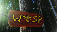
From Saunders, climb up the access road to the top of Wasp. Optional climbing trails include /Cherry Tomato, Corduroy & /Bomba, Backdoor.
From Doyle, get your steam on and climb up Cranks, /Bomba, and Backdoor.
Clear cuts are part of healthy forestry and recreational management. The city values the benefits of trails and works with the FVMBA to restore trails affected by logging. We enjoy our forests and trails as an evolving environment through natural environmental impact and controlled impact from logging.
Bear Mountain offers a variety of flow and technical trails. There is no shuttle access on this mountain.
Access is from Dewdney Trunk Road at the Mill Pond, Saunders parking lot off Richards, or Doyle Street.
These are a hand-built trails for light recreational use. Biking or hiking only. No horses or motorized vehicles are allowed on the single-track trails of Bear Mountain.
From Mill Pond, use Big Trouble in Little Chainring to climb up to Super Bear.
From Saunders, climb up the access road to the top of Wasp. Optional climbing trails include /Cherry Tomato, Corduroy & /Bomba, Backdoor.
From Doyle, get your steam on and climb up Cranks, /Bomba, and Backdoor.
Primary Trail Type: All-Mountain & Downhill
Land Status: City Managed
 google parking directions
 Region Supporters & Maintainers
- Mary Jane Duke
since 2024Maintainer
Activities Click to view
- Mountain Bike
55 trails
- E-Bike
4 trails
- Hike
53 trails
- Trail Running
53 trails
Region Details
- 15
- 1
- 6
- 25
- 8
Region Status
Open as of Jul 12, 2026Stats
- Avg Trail Rating
- Trails (view details)
- 55
- Trails Mountain Bike
- 55
- Trails E-Bike
- 4
- Trails Horse
- 1
- Trails Hike
- 53
- Trails Trail Running
- 53
- Total Distance
- 23 miles
- Total Descent
- 6,846 ft
- Total Vertical
- 1,190 ft
- Highest Trailhead
- 1,818 ft
- Reports
- 4,277
- Photos
- 1,715
- Ridden Counter
- 28,985
Popular Bear Mountain Mountain Biking Trails
• 100 ★ 4.5 • 1 mile • 0 ft • 1,593 •
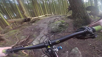
SuperBear is the same line as the old Bear DH Downhill course. Was machined in 2015, but with time has morphed back into a lot of its old self. Top-half is full-on black diamond downhill. Lower half is more flowy with some rollers/jumps...
• 100 ★ 4.4 • 1 mile • 681 ft • 1,557 •
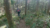
BTLC is an ascent trail for this side of the mountain. It was well built with good drainage considerations, some cedar bridges, and is generously wide. It is relatively smooth but has a sensible amount of bumps and shorter steep pitches...
• 100 ★ 4.0 • 1,781 ft • 0 ft • 1,257 •
is shorter now but it is still a good fun trail. Good trail to climb to from the and if coming down from the fire circle to it is fun techy winding with good flow.
• 100 ★ 4.2 • 1,402 ft • 146 ft • 1,151 •
Awesome short climbing trail - avoids grunt climb on access road takes you back to SA 100 and from there to the junction of Access 3 and BRSA100.
• 100 ★ 4.3 • 1,467 ft • 0 ft • 1,143 •
Great little addition after shooting down . Very similar feel with some tight tech rock in trail and lots of rollers for pumping to build speed. Drops you into .
• 95 ★ 3.5 • 1,351 ft • 63 ft • 1,003 •
Back door is a fun root filled connector trail with good tech sections and good times.
Bear Mountain Mountain Bike Routes
4 miles • 1,036 ft • 5 •
Fraser Valley Bear Quickie Relive Your Ride For other ride suggestions for this and other areas. As well...
12 miles • 3,153 ft • 14 •
Fraser Valley Bear Epic Fraser Valley Relive Your Ride For other ride suggestions for this and other...
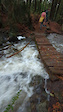
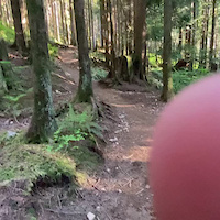
Photos of Bear Mountain Mountain Bike
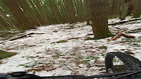
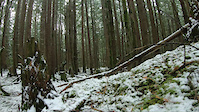
Videos of Bear Mountain Mountain Bike
trail: Merv's
0:08 |
39 |
Oct 27, 2024
trail: Lorax
2:44 |
|
Dec 21, 2021
trail: Super Bear
0:15 |
426 |
May 13, 2021
trail: Bear Buns
2:58 |
37 |
Apr 18, 2021
trail: Bigguns
0:22 |
188 |
Apr 12, 2021
trail: Bigguns
0:13 |
150 |
Apr 9, 2021

trail: Bigguns
0:13 |
73 |
Apr 9, 2021
trail: Lorax
9:26 |
91 |
Mar 30, 2021
Recent Trail Reports
| status | trail | date | condition | info | user |
|---|---|---|---|---|---|
| Super Bear | Jul 12, 2026 @ 3:20pm (America/Vancouver) Jul 12, 2026 | Ideal | sancosta | ||
| Bigguns | Jun 22, 2026 @ 3:34pm (America/Vancouver) Jun 22, 2026 | Ideal | gsallenbach | ||
| Bear Back | Jun 22, 2026 @ 3:34pm (America/Vancouver) Jun 22, 2026 | Ideal | gsallenbach | ||
| Lorax | Jun 22, 2026 @ 3:34pm (America/Vancouver) Jun 22, 2026 | Ideal | gsallenbach | ||
| Wasp | Jun 22, 2026 @ 3:34pm (America/Vancouver) Jun 22, 2026 | Ideal | gsallenbach | ||
| Backdoor | Jun 22, 2026 @ 3:34pm (America/Vancouver) Jun 22, 2026 | Ideal | gsallenbach | ||
| Bear Buns | Jun 22, 2026 @ 3:34pm (America/Vancouver) Jun 22, 2026 | Ideal | gsallenbach | ||
| Big Trouble Little Chainring | Jun 18, 2026 @ 11:46pm (America/Vancouver) Jun 18, 2026 | Unknown | RichVigurs | ||
| Jolly Rancher | Jun 11, 2026 @ 10:25am (America/Vancouver) Jun 11, 2026 | Variable | Sharonb Cypress | ||
| Smokin' Bobo | Jun 11, 2026 @ 10:25am (America/Vancouver) Jun 11, 2026 | Ideal | Sharonb Cypress |
Activity Feed
| username | action | type | title | date |
|---|---|---|---|---|
| darianmacdonald | add | video | activity #99504002 and 1 more | Jul 18, 2026 @ 10:56pm 2 days |
| ShawnBGSFK2 | ridden | trail | activity #99400327 and 1 more | Jul 17, 2026 @ 2:50pm Jul 17, 2026 |
| esksnow | wishlist | route | activity #99392781 | Jul 17, 2026 @ 12:36pm Jul 17, 2026 |
| betweenthewheels | add | karma | activity #99228085 | Jul 15, 2026 @ 3:35am Jul 15, 2026 |
| claudiamp27 | wishlist | trail | activity #99218737 | Jul 14, 2026 @ 10:13pm Jul 14, 2026 |
Recent Comments
| username | type | title | comment | date |
|---|---|---|---|---|
| trail | Mainly useful as a way to get somewhere; not... | May 31, 2026 @ 2:35pm May 31, 2026 | ||
| report | Trail name has been corrected | May 19, 2026 @ 5:30am May 19, 2026 | ||
| report | No prob. Just wanted to know where it was so I... | May 18, 2026 @ 4:32pm May 18, 2026 | ||
| report | Sorry, yes it is, this trail is the luge at ... | May 18, 2026 @ 4:21pm May 18, 2026 | ||
| report | I think this report is on the wrong trail...? | May 18, 2026 @ 12:41pm May 18, 2026 |
Nearby Areas
| name | distance | ||||
|---|---|---|---|---|---|
| Steelhead | 2 | 1 | 2.6 km | ||
| Heritage Trails | 10 | 6 | 8 | 2.9 km | |
| Red Mountain | 2 | 9 | 11 | 1 | 3.2 km |
| The Great Trail / Matsqui Dyke | 4.3 km | ||||
| Stave West - Rolley Lake | 4 | 2 | 5.2 km |
Local Badges
-

Completionist15 awarded
Bike & Skill Parks
| name | type | city | rating |
|---|---|---|---|
| Mill Pond Skills Loop | skill park | Mission |
Local Mountain Biking Directory
-
Phoenix Velo Training Group
-
Wentings CycleBike Shop
![Wentings Cycle]()
-
No Hype BikesBike Shop
Local Products
Activity Type Stats
| activitytype | trails | distance | descent | descent distance | total vertical | rating | global rank | state rank | photos | reports | routes | ridelogs |
|---|---|---|---|---|---|---|---|---|---|---|---|---|
| Mountain Bike | 55 | 23 miles | 6,847 ft | 12 miles | 1,191 ft | #454 | #51 | 1,693 | 4,273 | 7 | 15,480 | |
| E-Bike | 4 | 2 miles | 709 ft | 1 mile | 1,017 ft | #3,713 | #136 | 3 | 3,011 | 858 | ||
| Horse | 1 | 4,383 ft | 121 ft | 3,770 ft | 121 ft | 1,536 | ||||||
| Hike | 53 | 23 miles | 6,352 ft | 11 miles | 1,191 ft | #1,667 | #92 | 20 | 4,228 | 1,370 | ||
| Trail Running | 53 | 23 miles | 6,352 ft | 11 miles | 1,191 ft | #3,034 | #96 | 4,228 | 10 | 714 |
Frequently Asked Questions About Bear Mountain
▼
What are the highest rated mountain biking trails in Bear Mountain?
The highest rated mountain biking trails in Bear Mountain are:
- Lorax (4.5/5)
- Super Bear (4.4/5)
- Big Trouble Little Chainring (4.3/5)
- Bear Buns (4.3/5)
- Bearea 51 (4.2/5)
▼
What is the best time of the year to ride in Bear Mountain?
Based on ride log data, the most popular months to ride in Bear Mountain are:
- May (279 activities)
- June (246 activities)
- July (246 activities)
▼
Where can I park to ride in Bear Mountain?
There are 3 parking locations listed in Bear Mountain. The most popular parking spots are: View all parking and trailhead locations on the map to plan your visit.
▼
What is the longest trail in Bear Mountain?
The longest trail in Bear Mountain is Big Trouble Little Chainring at 1.5 miles. View all trails sorted by distance.
Activities
Trails
- By canadaka
 Trailforks & contributors
 - Admins: FVMBA-Mission, FVMBA - ADMIN, lee5986, meghanjackson, Graham-Macaulay, FVMBA-Mission
- #240 - 78,701 views
- bear mountain activity log | embed map of Bear Mountain mountain bike trails | bear mountain mountain biking points of interest
Downloading of trail gps tracks in kml & gpx formats is enabled for Bear Mountain.
You must login to download files.