close
-
Layers w
- Weather Layers
- Pro
- Pro
- Pro
- Pro
- Pro
- Pro
- More Layers
- Pro
- Pro
- Pro
- Pro
-
Upgrade to

3D
Trail Conditions
- Unknown
- Snow Groomed
- Snow Packed
- Snow Covered
- Snow Cover Partial
- Freeze/thaw Cycle
- Icy
- Prevalent Mud
- Wet
- Variable
- Ideal
- Dry
- Very Dry
Trail Flow (Ridden Direction)
Trailforks scans users activity logs to determine the most popular direction each trail is ridden. A good flowing trail network will have most trails flowing in a single direction according to their intension.
The colour categories are based on what percentage of users are riding a trail in its intended direction.
The colour categories are based on what percentage of users are riding a trail in its intended direction.
- > 96%
- > 90%
- > 80%
- > 70%
- > 50%
- < 50%
- bi-directional trail
- no data
Trail Last Ridden
Trailforks scans activity logs to determine the last time a trail was ridden.
- < 2 days
- < 1 week
- < 2 weeks
- < 1 month
- < 6 months
- > 6 months
Trail Ridden Direction
The intended direction a trail should be ridden.
- Downhill Only
- Downhill Primary
- Both Directions
- Uphill Primary
- Uphill Only
- One Direction
Contribute Details
Colors indicate trail is missing specified detail.
- Description
- Photos
- Description & Photos
- Videos
Trail Popularity ?
Trailforks scans activity logs to determine which trails are ridden the most in the last 9 months.
Trails are compared with nearby trails in the same city region with a possible 25 colour shades.
Think of this as a heatmap, more activities = more kinetic energy = warmer colors.
- most popular
- popular
- less popular
- not popular
ATV/ORV/OHV Filter
Max Vehicle Width
inches
US Cell Coverage
Legend

Radar Time
Activity Recordings
Trailforks uses anonymized public activity data.
?
Activity Recordings
Trailforks uses anonymized public activity data.
?
Personal Heatmap
▶
Activity Types
all
/
none
▶
Options
2
Date range
month
–
Winter Trails
Warning
A routing network for winter maps does not exist. Selecting trails using the winter trails layer has been disabled.
Missing Trails
Most Popular
Least Popular
Trails are colored based on popularity. The more popular a trail is, the more red. Less popular trails trend towards green.
Jump Magnitude Heatmap
Heatmap of where users jump on trails. Zoom in to see individual jumps, click circles to view jump details.
BC Backroad Status
![map legend]()
Service Road Atlas is a free to use, community-driven service for viewing and creating reports on the numerous back-country service roads around B.C. and Alberta.

Slope Aspect
Direction the slope faces
Trails Deemphasized
Trails are shown in grey.
Only show trails with no bike usage.
Suggested Layers
Based on selected activity type
Save the current map location and zoom level as your default home location whenever this page is loaded.
SaveWhen Dr. Sean Morrissy started building a trail in Minto to get his mountain bike fix after work, he soon realized he’d stumbled upon a goldmine.
A practicing physician in Minto for almost 19 years, Morrissy took up mountain biking 14 years ago.
The four-kilometre trail he started, and doubled in distance within a year, has now expanded “to between 30 and 40 kilometres, thanks to all the help I’ve received since then,” he said.
“It’s not that I’m an amazing trail builder or anything. It’s the terrific terrain.”
Primary Trail Type: Cross-Country
Land Status: Crown Land
Links
Activities Click to view
- Mountain Bike
56 trails
- E-Bike
8 trails
- Gravel Bike
0 trails
- Adaptive Bike
0 trails
- Winter Fat Bike
0 trails
- Hike
54 trails
- Trail Running
54 trails
- Snowmobile
5 trails
- Snowshoe
15 trails
- Backcountry Ski
5 trails
- Nordic Ski
5 trails
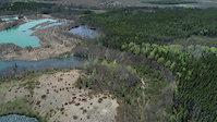
Region Details
- 8
- 1
- 14
- 22
- 11
Region Status
Open as of Jul 18, 2026Stats
- Avg Trail Rating
- Trails (view details)
- 56
- Trails Mountain Bike
- 57
- Trails E-Bike
- 8
- Trails Hike
- 54
- Trails Trail Running
- 54
- Trails Snowmobile
- 5
- Trails Snowshoe
- 15
- Trails Backcountry Ski
- 5
- Trails Nordic Ski
- 5
- Total Distance
- 29 miles
- Total Descent
- 614 ft
- Total Vertical
- 143 ft
- Highest Trailhead
- 268 ft
- Reports
- 644
- Photos
- 303
- Completed Counter
- 13,706
Sub Regions
-
New England
- 11
- 13
- 8
-
The Legacy Trails
- 1
- 2
- 4
- 2
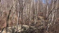
Popular Minto Mountain Biking Trails
• 90 ★ 4.6 • 1 mile • 15 ft • 574 •
Incredible! Like nothing I've ever ridden. Fun for both beginners and pros. Great trail jriordon 2020 A roller coaster ride of excitement and thrills. Does not exist anywhere else in this dimension. Woofman 2020
• 100 ★ 3.3 • 659 ft • 2 ft • 499 •
Popular blue difficulty singletrack. This mountain bike primary trail can be used both directions. It features bridge. On average it takes 1 minutes to complete this trail.
• 95 ★ 4.4 • 479 ft • 5 ft • 392 •
Shortens to only 4 ridge runs, instead of 10.
• 85 ★ 4.7 • 2 miles • 16 ft • 386 •
Highly rated popular blue difficulty singletrack. This mountain bike primary trail can be used both directions and has a moderate overall physical rating with a 16 ft green climb. On average it takes 17 minutes to complete this trail.
• 85 ★ 4.5 • 3,802 ft • 15 ft • 382 •
Highly rated popular green difficulty singletrack. This mountain bike primary trail can be used both directions and has a moderate overall physical rating with a 15 ft green climb. It features bridge. On average it takes 6 minutes to complete this trail.
• 60 ★ 4.5 • 3,068 ft • 10 ft • 364 •
A beginner friendly alternative to on the way out, or an alternative to the Orange Tape Road on the way back in.
Minto Mountain Bike Routes
★ 4.0 • 9 miles • 128 ft • 11 •
Part Loop and Part Out & Back, this route combines Intermediate and Easy trails for a fun tour of the...
12 miles • 235 ft • 17 •
The Whole Lobster Roll 2024 Crusty and crunch on the outside. Super smooth and slick on the inside. All a...
3 miles • 54 ft • 5 •
The Lobster Claw 2024- Its a delicacy. Smooth and easy this year. But be careful it might bite you in the...
32 miles • 640 ft • 47 •
Every trail in the MTB Minto system including the new 2020-21 northern network. MTBM has created The Whole...
3 miles • 48 ft • 6 •
First created for a team building for the Design Branch of NBDTI. This is a proposed Beginner rider route....
3 miles • 48 ft • 6 •
Beginner rider route , originally created for the Design Branch team building day.,
Photos of Minto Mountain Bike
Videos of Minto Mountain Bike

trail: Dragline
0:08 |
157 |
Apr 30, 2020
trail: Dragline
0:06 |
95 |
Apr 30, 2020
trail: Insanity Later
4:09 |
575 |
Sep 25, 2019

7:10 |
51 |
Nov 13, 2025
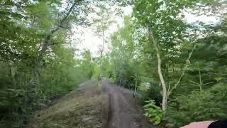
trail: Insanity Later
2:35 |
87 |
Aug 31, 2025 , Minto

trail: Serenity Now
6:18 |
338 |
Aug 14, 2023 , Minto

trail: Forlorne
0:27 |
230 |
Aug 14, 2023 , Minto

trail: Doctor's Orders
4:48 |
298 |
Aug 14, 2023 , Minto
Recent Trail Reports
| status | trail | date | condition | info | user |
|---|---|---|---|---|---|
| Dragline | Jul 18, 2026 @ 10:29am (America/Moncton) Jul 18, 2026 | Ideal | Sebastien685 | ||
| Orange Tape Road | Jul 18, 2026 @ 10:29am (America/Moncton) Jul 18, 2026 | Ideal | Sebastien685 | ||
| Scotia Banks | Jul 18, 2026 @ 10:29am (America/Moncton) Jul 18, 2026 | Ideal | Sebastien685 | ||
| The Shuttle Bus | Jul 18, 2026 @ 10:29am (America/Moncton) Jul 18, 2026 | Ideal | Sebastien685 | ||
| Tabula Rasa | Jul 18, 2026 @ 10:29am (America/Moncton) Jul 18, 2026 | Ideal | Sebastien685 | ||
| Tabula Rasa Shortcut Connector | Jul 18, 2026 @ 10:29am (America/Moncton) Jul 18, 2026 | Ideal | Sebastien685 | ||
| Rushin' Thru | Jul 18, 2026 @ 10:29am (America/Moncton) Jul 18, 2026 | Ideal | Sebastien685 | ||
| Serenity Now | Jul 18, 2026 @ 10:29am (America/Moncton) Jul 18, 2026 | Ideal | Sebastien685 | ||
| Insanity Later | Jul 18, 2026 @ 10:29am (America/Moncton) Jul 18, 2026 | Ideal | Sebastien685 | ||
| Coal Country | Jul 18, 2026 @ 10:29am (America/Moncton) Jul 18, 2026 | Ideal | Sebastien685 |
Activity Feed
| username | action | type | title | date |
|---|---|---|---|---|
| Johnbelli | vote | trail | activity #100235423 | Jul 28, 2026 @ 4:54pm 9 hours |
| rktarr | wishlist | route | activity #100233817 | Jul 28, 2026 @ 4:28pm 9 hours |
| JimNE | wishlist | route | activity #100199912 and 1 more | Jul 28, 2026 @ 7:41am 18 hours |
| Wesson | ridden | route | activity #100188617 | Jul 28, 2026 @ 4:10am 21 hours |
| JimNE | add | photo | activity #100165507 | Jul 27, 2026 @ 5:15pm 1 day |
Recent Comments
| username | type | title | comment | date |
|---|---|---|---|---|
| trail | old school MTB trail at his best. Mix of roots... | Jul 21, 2026 @ 4:22am Jul 21, 2026 | ||
| trail | Very fun and perfect for practice | Jul 21, 2026 @ 4:15am Jul 21, 2026 | ||
| report | Nicely done :) | May 1, 2026 @ 5:04pm May 1, 2026 | ||
| trail | Couple of trees down on trail | Apr 30, 2026 @ 2:17pm Apr 30, 2026 | ||
| report | Its open | Sep 2, 2025 @ 6:34am Sep 2, 2025 |
Local Badges
-

The Whole Lobster Roll 20241 awarded -

The Claw3 awarded -

Epic Ride 50k66 awarded -

Big Ride 30k227 awarded -

Top 10 Trails64 awarded -

Completionist15 awarded
Activity Type Stats
| activitytype | trails | distance | descent | descent distance | total vertical | rating | global rank | state rank | photos | reports | routes | activity logs |
|---|---|---|---|---|---|---|---|---|---|---|---|---|
| Mountain Bike | 56 | 29 miles | 614 ft | 7 miles | 144 ft | #1,475 | #6 | 298 | 644 | 41 | 4,471 | |
| E-Bike | 8 | 2 miles | 20 ft | 1,696 ft | 102 ft | #6,092 | #14 | 367 | 69 | |||
| Hike | 54 | 27 miles | 584 ft | 6 miles | 144 ft | #5,383 | #12 | 5 | 629 | 123 | ||
| Trail Running | 54 | 27 miles | 584 ft | 6 miles | 144 ft | #4,845 | #7 | 628 | 1 | 54 | ||
| Snowmobile | 5 | 1,270 ft | 13 ft | 515 ft | 13 ft | #235 | #3 | 4 | ||||
| Snowshoe | 15 | 2 miles | 26 ft | 1,227 ft | 105 ft | #1,016 | #9 | 36 | 31 | |||
| Backcountry Ski | 5 | 1,270 ft | 13 ft | 515 ft | 13 ft | #508 | #2 | 6 | 21 | |||
| Nordic Ski | 5 | 1,270 ft | 13 ft | 515 ft | 13 ft | #1,133 | #5 | 6 | 20 |
Frequently Asked Questions About Minto
▼
What are the best places to ride in Minto?
Minto has 2 areas to explore for mountain biking. The top rated areas are:
▼
What are the highest rated mountain biking trails in Minto?
The highest rated mountain biking trails in Minto are:
- Insanity Later (4.4/5)
- Caveat Emptor (4.4/5)
- Tabula Rasa (4.3/5)
- Not Stirred (4.3/5)
- Novel Strain (4.3/5)
▼
What is the best time of the year to ride in Minto?
Based on activity log data, the most popular months to ride in Minto are:
- July (102 activities)
- June (100 activities)
- August (97 activities)
▼
Where can I park to ride in Minto?
There are 4 parking locations listed in Minto. The most popular parking spots are: View all parking and trailhead locations on the map to plan your visit.
Activities
Trails
- By alexisberube RVC & contributors
- Admins: MTBM, BTA
- #5502 - 30,159 views
- minto activity log | embed map of Minto mountain bike trails | minto mountain biking points of interest
Downloading of trail gps tracks in kml & gpx formats is enabled for Minto.
You must login to download files.