close
-
Layers w
- Weather Layers
- Pro
- Pro
- Pro
- Pro
- Pro
- Pro
- More Layers
- Pro
- Pro
- Pro
- Pro
-
Upgrade to

3D
Trail Conditions
- Unknown
- Snow Groomed
- Snow Packed
- Snow Covered
- Snow Cover Partial
- Freeze/thaw Cycle
- Icy
- Prevalent Mud
- Wet
- Variable
- Ideal
- Dry
- Very Dry
Trail Flow (Ridden Direction)
Trailforks scans users ridelogs to determine the most popular direction each trail is ridden. A good flowing trail network will have most trails flowing in a single direction according to their intension.
The colour categories are based on what percentage of riders are riding a trail in its intended direction.
The colour categories are based on what percentage of riders are riding a trail in its intended direction.
- > 96%
- > 90%
- > 80%
- > 70%
- > 50%
- < 50%
- bi-directional trail
- no data
Trail Last Ridden
Trailforks scans ridelogs to determine the last time a trail was ridden.
- < 2 days
- < 1 week
- < 2 weeks
- < 1 month
- < 6 months
- > 6 months
Trail Ridden Direction
The intended direction a trail should be ridden.
- Downhill Only
- Downhill Primary
- Both Directions
- Uphill Primary
- Uphill Only
- One Direction
Contribute Details
Colors indicate trail is missing specified detail.
- Description
- Photos
- Description & Photos
- Videos
Trail Popularity ?
Trailforks scans ridelogs to determine which trails are ridden the most in the last 9 months.
Trails are compared with nearby trails in the same city region with a possible 25 colour shades.
Think of this as a heatmap, more rides = more kinetic energy = warmer colors.
- most popular
- popular
- less popular
- not popular
ATV/ORV/OHV Filter
Max Vehicle Width
inches
US Cell Coverage
Legend

Radar Time
Activity Recordings
Trailforks uses anonymized public activity data.
?
Activity Recordings
Trailforks uses anonymized public activity data.
?
Personal Heatmap
▶
Activity Types
all
/
none
▶
Options
2
Date range
month
–
Winter Trails
Warning
A routing network for winter maps does not exist. Selecting trails using the winter trails layer has been disabled.
Missing Trails
Most Popular
Least Popular
Trails are colored based on popularity. The more popular a trail is, the more red. Less popular trails trend towards green.
Jump Magnitude Heatmap
Heatmap of where riders jump on trails. Zoom in to see individual jumps, click circles to view jump details.
BC Backroad Status
![map legend]()
Service Road Atlas is a free to use, community-driven service for viewing and creating reports on the numerous back-country service roads around B.C. and Alberta.

Slope Aspect
Direction the slope faces
Trails Deemphasized
Trails are shown in grey.
Only show trails with no bike usage.
Suggested Layers
Based on selected activity type
Save the current map location and zoom level as your default home location whenever this page is loaded.
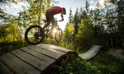
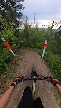
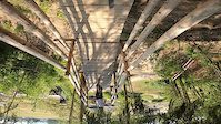
SaveAt the North end of the Cariboo, the riding in Quesnel offers a different landscape and experience than found in nearby riding areas. The rocky single track leans towards a more technical style with a built experience to link trails of increasing skill level. Not everything in Quesnel is technical; all three riding areas have machine built flow trails that are friendly for all riders, regardless of skill level. Put Quesnel on your list of riding destinations, it’s hard to access Northern BC riding without a stop here
Activities Click to view
- Mountain Bike
86 trails
- E-Bike
32 trails
- Gravel Bike
2 trails
- Adaptive Bike
11 trails
- Winter Fat Bike
7 trails
- Horse
4 trails
- Hike
67 trails
- Trail Running
67 trails
- Dirtbike/Moto
50 trails
- ATV/ORV/OHV
1 trails
- Snowshoe
11 trails
- Downhill Ski
37 trails
- Nordic Ski
7 trails
Region Details
- 6
- 3
- 39
- 23
- 14
- 1
Region Status
Open as of May 24, 2026Stats
- Avg Trail Rating
- Trails (view details)
- 173
- Trails Mountain Bike
- 86
- Trails E-Bike
- 32
- Trails Gravel Bike
- 2
- Trails Adaptive Bike
- 11
- Trails Winter Fat Bike
- 7
- Trails Horse
- 4
- Trails Hike
- 67
- Trails Trail Running
- 67
- Trails Dirtbike/Moto
- 50
- Trails ATV/ORV/OHV
- 1
- Trails Snowshoe
- 11
- Trails Downhill Ski
- 37
- Trails Nordic Ski
- 7
- Total Distance
- 126 miles
- Total Descent
- 36,229 ft
- Total Vertical
- 3,490 ft
- Highest Trailhead
- 5,036 ft
- Reports
- 855
- Photos
- 335
- Ridden Counter
- 7,423
Articles
From Chainsaws to Singletrack: How Mountain Biking Reinvigorated a BC Timber Town
Jun 12, 2025 from pinkbike.com
How mountain biking didn't just change Quesnel's outdoor recreation, it helped revive the community’s spirit and future.
Sub Regions
-
Dragon Mountain
- 2
- 4
- 7
-
Fuel Management Trails
- 4
-
Quesnel Bike Park
- 9
- 7
- 4
- 1
-
Wonderland
- 8
- 9
- 3
Popular Quesnel Mountain Biking Trails
• 95 ★ 4.9 • 1 mile • 13 ft • 395 •
Ride this one and ask yourself: “where am I?” You’ll feel like you’re in a ski resort bike park. This one is wide and creamy as it flows from berm to berm. As expected, you can get some major speed here, so it’s only for bikes...
• 100 ★ 4.2 • 2,205 ft • 0 ft • 282 •
Any skier knows that the words Gully Run mean that it’s the most fun run on the mountain and perfectly translates that into dirt. This one really takes advantage of the landscape, twisting back and forth across a broad gully and...
• 90 ★ 4.7 • 3,251 ft • 0 ft • 204 •
Get your speed up on the top half for big jumps and gaps. Second half features more technical downhill riding.
• 85 ★ 4.4 • 1 mile • 94 ft • 190 •
Upgraded in 2021 with TTFs and buffing. Wonderland is a challenging xc style trail. 2 climbs separated by rewarding downhill. After the junction the descent is technical, interspersed with different TTFs. A must ride in the area!
• 95 ★ 4.8 • 2,313 ft • 0 ft • 187 •
Black downhill oriented trail. TTFs include drops and long skinnies. As always, pre-ride, re-ride then free ride any trail features. Prepare for fun times!
• 95 ★ 3.7 • 2,415 ft • 94 ft • 185 •
This loop is perfect for families and beginners. Watch for practice trail features such as rolls, drops, rock gardens, bridges and a skinny. Great warm up before the climb, can connect onto What the Huck.
• 75 ★ 4.8 • 1 mile • 365 ft • 179 •
provides a smooth, wide machine-built surface that will put a smile on everyone’s face. Gentle climb with a couple punchy spots to challenge yourself. You’ll cross the road at 1.6 km, before continuing onto Rock in the Park. A few...
Quesnel Mountain Bike Routes
5 miles • 1,182 ft • 5 • Point to Point • Race •
6 miles • 1,150 ft • 11 • Loop • Race •
4 miles • 902 ft • 8 • Loop • Race •
3 miles • 664 ft • 9 • Loop • Race •
Photos of Quesnel Mountain Bike
Videos of Quesnel Mountain Bike
trail: Breakerfall
0:17 |
27 |
Jun 30, 2025
trail: Breakerfall
0:15 |
86 |
Jul 25, 2024
trail: Black Dirt Jumps
0:16 |
|
Mar 24, 2024
trail: Wonderland
0:15 |
34 |
May 15, 2023
0:10 |
45 |
Sep 7, 2022
0:13 |
45 |
Sep 7, 2022
0:09 |
36 |
Aug 30, 2022
trail: Around the Bend
0:44 |
82 |
Aug 20, 2022
Recent Trail Reports
| status | trail | date | condition | info | user |
|---|---|---|---|---|---|
| 7 Dwarves | May 24, 2026 @ 9:29pm (America/Vancouver) May 24, 2026 | Ideal | Adammushumanski | ||
| Hewitt's Lower | May 24, 2026 @ 9:28pm (America/Vancouver) May 24, 2026 | Ideal | Adammushumanski | ||
| Hewitt's Upper | May 24, 2026 @ 9:28pm (America/Vancouver) May 24, 2026 | Ideal | Adammushumanski | ||
| Rockasaurus | May 24, 2026 @ 9:28pm (America/Vancouver) May 24, 2026 | Ideal | Adammushumanski | ||
| Angry Beaver | May 21, 2026 @ 12:53pm (America/Dawson_Creek) May 21, 2026 | Variable | loganculbertmtb | ||
| WoodBurrys Way | May 21, 2026 @ 12:53pm (America/Dawson_Creek) May 21, 2026 | Variable | loganculbertmtb | ||
| Connector 5 | May 21, 2026 @ 12:53pm (America/Dawson_Creek) May 21, 2026 | Prevalent Mud | loganculbertmtb | ||
| Kids Loop | May 21, 2026 @ 12:53pm (America/Dawson_Creek) May 21, 2026 | Prevalent Mud | loganculbertmtb | ||
| Flying Monkeys | May 21, 2026 @ 12:53pm (America/Dawson_Creek) May 21, 2026 | Prevalent Mud | loganculbertmtb | ||
| 001 | May 21, 2026 @ 12:53pm (America/Dawson_Creek) May 21, 2026 | Prevalent Mud | loganculbertmtb |
Activity Feed
| username | action | type | title | date |
|---|---|---|---|---|
| daljinderm | ridden | trail | activity #97040806 | Jun 15, 2026 @ 7:45am 3 days |
| daljinderm | ridden | trail | activity #96811650 and 1 more | Jun 12, 2026 @ 10:05am Jun 12, 2026 |
| JerryVan | comment | trail | activity #96118338 | Jun 2, 2026 @ 4:37pm Jun 2, 2026 |
| mccycle | ridden | trail | activity #96053682 | Jun 1, 2026 @ 5:58pm Jun 1, 2026 |
| nicklocascio45 | wishlist | trail | activity #95823846 | May 29, 2026 @ 10:12pm May 29, 2026 |
Recent Comments
| username | type | title | comment | date |
|---|---|---|---|---|
| trail | Such a great trail, I just had to ride it... | Jun 2, 2026 @ 4:37pm Jun 2, 2026 | ||
| trail | This would be rated a solid black on the North... | Mar 22, 2026 @ 5:25pm Mar 22, 2026 | ||
| trail | Great trail! Spicy! | Sep 18, 2025 @ 10:47am Sep 18, 2025 | ||
| trail | Small drop 6 inch big drop is a foot and a... | Aug 13, 2025 @ 3:34pm Aug 13, 2025 | ||
| trail | Satans Bed :) Be careful on the step up drop... | Aug 13, 2025 @ 3:31pm Aug 13, 2025 |
Local Badges
-

10 Blue Trails97 awarded -

Epic Ride Climb 2k9 awarded -

Climbing 10k Badge29 awarded -

Climbing 100k Badge3 awarded -

Epic Ride Descent 2k10 awarded -

Descent 10k Badge29 awarded
Bike & Skill Parks
| name | type | city | rating |
|---|---|---|---|
| Paved Pump Track | skill park | Quesnel | |
| South Quesnel Park | skill park | Quesnel | |
| Dirt Jumps | skill park | Quesnel | |
| Strider Zone (Kids) | skill park | Quesnel | |
| Paved Pump Track | skill park | Quesnel |
Activity Type Stats
| activitytype | trails | distance | descent | descent distance | total vertical | rating | global rank | state rank | photos | reports | routes | ridelogs |
|---|---|---|---|---|---|---|---|---|---|---|---|---|
| Mountain Bike | 86 | 61 miles | 13,245 ft | 28 miles | 2,661 ft | #1,313 | #56 | 314 | 854 | 16 | 8,604 | |
| E-Bike | 32 | 31 miles | 5,171 ft | 15 miles | 2,549 ft | #2,543 | #68 | 1 | 619 | 2 | 300 | |
| Gravel Bike | 2 | 2 miles | 358 ft | 3,967 ft | 801 ft | #329 | #93 | 98 | 22 | |||
| Adaptive Bike | 11 | 15 miles | 2,822 ft | 9 miles | 2,549 ft | #230 | #108 | 132 | 1 | |||
| Winter Fat Bike | 7 | 9 miles | 2,493 ft | 6 miles | 2,408 ft | #197 | #92 | 117 | ||||
| Horse | 4 | 7 miles | 2,323 ft | 6 miles | 2,470 ft | #1,219 | #44 | 215 | ||||
| Hike | 67 | 55 miles | 11,332 ft | 25 miles | 2,661 ft | #1,673 | #69 | 15 | 753 | 2 | 850 | |
| Trail Running | 67 | 55 miles | 11,332 ft | 25 miles | 2,661 ft | #2,417 | #72 | 753 | 2 | 675 | ||
| Dirtbike/Moto | 50 | 45 miles | 4,117 ft | 19 miles | 620 ft | #269 | #33 | 208 | 34 | |||
| ATV/ORV/OHV | 1 | #536 | #40 | 208 | 6 | |||||||
| Snowshoe | 11 | 9 miles | 1,627 ft | 4 miles | 505 ft | #592 | #47 | 20 | 50 | |||
| Downhill Ski | 37 | 21 miles | 18,868 ft | 20 miles | 1,713 ft | #314 | #18 | 1 | 19 | 351 | ||
| Nordic Ski | 7 | 2 miles | 197 ft | 4,016 ft | 118 ft | #701 | #39 | 18 | 481 |
Frequently Asked Questions About Quesnel
▼
What are the best places to ride in Quesnel?
Quesnel has 6 areas to explore for mountain biking. The top rated areas are:
▼
What are the highest rated mountain biking trails in Quesnel?
The highest rated mountain biking trails in Quesnel are:
- Mucho Oro (4.5/5)
- Rockin' The Park (4.4/5)
- The Rabbit Hole (4.3/5)
- Walk In The Park (4.3/5)
- Rockasaurus (4.3/5)
▼
What is the best time of the year to ride in Quesnel?
Based on ride log data, the most popular months to ride in Quesnel are:
- July (144 activities)
- September (97 activities)
- August (79 activities)
▼
Where can I park to ride in Quesnel?
There are 4 parking locations listed in Quesnel. The most popular parking spots are:
- Wonderland Network Parking & Staging Area
- Parking for Quesnel Bike Park
- Main Parking & Staging Area
- Fuel Management Trails
Activities
Trails
Points of Interest
- Wood Roll TTF
- Information Kiosk and Map
- Information Kiosk and Map
- Information Kiosk and Map
- The Red Bench Viewpoint
- Wallride TTF
- Toilet Bowl (Over/Under) TTF
- Wallride TTF
- Washrooms Information
- Advanced Progressive Jumpline Drop In TTF
- Eaglenest Mountain (1,744 m)
- Dragon Mountain (1,712 m)
- Sovereign Mountain (1,669 m)
- By aggro & contributors
- Admins: BCBR, TrailsBC, BCORMA, DSBC, wheelmaniac3, bcpunk, CMBC, GRCC
- #8157 - 22,120 views
- quesnel activity log | embed map of Quesnel mountain bike trails | quesnel mountain biking points of interest
Downloading of trail gps tracks in kml & gpx formats is enabled for Quesnel.
You must login to download files.