close
-
Layers w
- Weather Layers
- Pro
- Pro
- Pro
- Pro
- Pro
- Pro
- More Layers
- Pro
- Pro
- Pro
- Pro
-
Upgrade to

3D
Trail Conditions
- Unknown
- Snow Groomed
- Snow Packed
- Snow Covered
- Snow Cover Partial
- Freeze/thaw Cycle
- Icy
- Prevalent Mud
- Wet
- Variable
- Ideal
- Dry
- Very Dry
Trail Flow (Ridden Direction)
Trailforks scans users ridelogs to determine the most popular direction each trail is ridden. A good flowing trail network will have most trails flowing in a single direction according to their intension.
The colour categories are based on what percentage of riders are riding a trail in its intended direction.
The colour categories are based on what percentage of riders are riding a trail in its intended direction.
- > 96%
- > 90%
- > 80%
- > 70%
- > 50%
- < 50%
- bi-directional trail
- no data
Trail Last Ridden
Trailforks scans ridelogs to determine the last time a trail was ridden.
- < 2 days
- < 1 week
- < 2 weeks
- < 1 month
- < 6 months
- > 6 months
Trail Ridden Direction
The intended direction a trail should be ridden.
- Downhill Only
- Downhill Primary
- Both Directions
- Uphill Primary
- Uphill Only
- One Direction
Contribute Details
Colors indicate trail is missing specified detail.
- Description
- Photos
- Description & Photos
- Videos
Trail Popularity ?
Trailforks scans ridelogs to determine which trails are ridden the most in the last 9 months.
Trails are compared with nearby trails in the same city region with a possible 25 colour shades.
Think of this as a heatmap, more rides = more kinetic energy = warmer colors.
- most popular
- popular
- less popular
- not popular
ATV/ORV/OHV Filter
Max Vehicle Width
inches
US Cell Coverage
Legend

Radar Time
Activity Recordings
Trailforks uses anonymized public activity data.
?
Activity Recordings
Trailforks uses anonymized public activity data.
?
Personal Heatmap
▶
Activity Types
all
/
none
▶
Options
2
Date range
month
–
Winter Trails
Warning
A routing network for winter maps does not exist. Selecting trails using the winter trails layer has been disabled.
Missing Trails
Most Popular
Least Popular
Trails are colored based on popularity. The more popular a trail is, the more red. Less popular trails trend towards green.
Jump Magnitude Heatmap
Heatmap of where riders jump on trails. Zoom in to see individual jumps, click circles to view jump details.
BC Backroad Status
![map legend]()
Service Road Atlas is a free to use, community-driven service for viewing and creating reports on the numerous back-country service roads around B.C. and Alberta.

Slope Aspect
Direction the slope faces
Trails Deemphasized
Trails are shown in grey.
Only show trails with no bike usage.
Suggested Layers
Based on selected activity type
Save the current map location and zoom level as your default home location whenever this page is loaded.
SaveNorsk:
Rusteåne – naturskjønne stier med god flyt
I sørvendt og solrik furuskog opp fra Riksvei 7, mellom Herad og Gol, finner du de naturlige stiene i Rusteåne-området. Stiene ligger på både vest- og østsiden av elven Rusteåne, og byr på fine partier med naturlig flyt og muligheter for god fart ned gjennom skogen. Husk å vise hensyn til turgåere
English:
Rusteåne – scenic natural trails with great flow
Located in the south-facing, sunlit pine forest above Highway 7 between Herad and Gol, the Rusteåne area offers natural trails with plenty of flow and speed potential. The trails run on both the west and east sides of the Rusteåne river. Remember to respect hikers on the trails!
Primary Trail Type: All-Mountain & Downhill
Access Info:
Norsk:
Adkomst til toppen av stiene skjer via grusveier. Herad kirke (øst for Gol sentrum) og bensinstasjonen Shell langs RV7 er gode utgangspunkt for turer i dette området.
English:
Access to the top of the trails is via gravel roads. Herad Church (east of Gol town center) and the Shell gas station along Highway 7 are great starting points for exploring this area.
This region uses the Uk/Euro style trail grading system.
Activities Click to view
- Mountain Bike
5 trails
- E-Bike
5 trails
- Hike
4 trails
- Trail Running
4 trails
Region Details
- 1
- 1
- 3
Region Status
Open as of Nov 16, 2025Stats
- Trails (view details)
- 5
- Trails Mountain Bike
- 5
- Trails E-Bike
- 5
- Trails Hike
- 4
- Trails Trail Running
- 4
- Total Distance
- 8 miles
- Total Descent Distance
- 4 miles
- Total Descent
- 3,784 ft
- Total Vertical
- 1,641 ft
- Highest Trailhead
- 2,278 ft
- Reports
- 8
- Photos
- 2
- Ridden Counter
- 49
Popular Rusteåne // Vindfallet Mountain Biking Trails
• 65 ★ 4.5 • 5,003 ft • 3 ft • 49 •
En av de aller beste stiene i Gol-området! Hoveddelen av stien holder god fart, men du møter også noen tekniske partier underveis. Starten byr på tråkking og flyt før du krysser grusveien for første gang. Derfra blir terrenget...
• 70 ★ 5.0 • 3,842 ft • 51 ft • 38 •
En morsom og teknisk sti som krever både tråkking og innsats. Underlaget er ganske steinete, og dette er en sti hvor du må jobbe litt for å holde flyten. Når du kommer ned til grusveien og kraftstasjonen, følger du venstre side av...
• 85 ★ 0.0 • 2 miles • 474 ft • 15 •
Denne stien byr på 450 høydemeter med fart og flyt, der du følger smale stier og gamle traktorveier. Slipp bremsene og nyt turen ned! Stibeskrivelse Start på traktorvei. Ta første avstikker til venstre, og følg stien med ravinen...
• 5 ★ 0.0 • 938 ft • 0 ft • 3 •
En lengre alternativ forlengelse av . Stien starter med litt tekniske partier og noen krappe svinger før den åpner opp mot slutten og gir mulighet for høyere fart. Når du kommer ned til grusveien igjen, følger du denne ca. 200...
Videos of Rusteåne // Vindfallet Mountain Bike
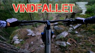
trail: Vindfallet
6:27 |
96 |
Mar 21, 2025 , Gol
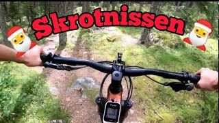
trail: Skrotnissen
4:12 |
78 |
Mar 21, 2025 , Gol
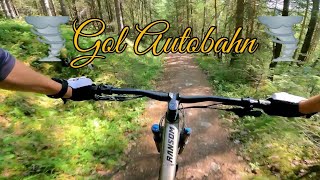
trail: Gol Autobahn
7:35 |
187 |
Mar 21, 2025 , Gol
Recent Trail Reports
| status | trail | date | condition | info | user |
|---|---|---|---|---|---|
| Vindfallet | Sep 1, 2024 @ 2:33pm Sep 1, 2024 | Ideal | zzdenek | ||
| Skrotnissen | Jul 14, 2023 @ 11:23pm Jul 14, 2023 | Ideal | Kjetilfp | ||
| Skrotnissen Ekstra | Jul 14, 2023 @ 11:23pm Jul 14, 2023 | Ideal | Kjetilfp |
Activity Feed
| username | action | type | title | date |
|---|---|---|---|---|
| wimpiej | wishlist | trail | activity #77831638 and 3 more | Aug 10, 2025 @ 8:37am Aug 10, 2025 |
| OeysteinNuSItx | wishlist | trail | activity #77344244 | Aug 3, 2025 @ 1:34pm Aug 3, 2025 |
| Gabester1989 | wishlist | trail | activity #76844387 | Jul 27, 2025 @ 12:28pm Jul 27, 2025 |
| Tomknobel | ridden | trail | activity #76101646 | Jul 17, 2025 @ 10:52am Jul 17, 2025 |
| larsstorheim | update | region | activity #74159702 | Jun 20, 2025 @ 1:16am Jun 20, 2025 |
Nearby Areas
| name | distance | ||||
|---|---|---|---|---|---|
| Hallingmo Stisenter / Trail Centre | 6 | 1 | 1.6 km | ||
| Golsfjellet | 6 | 9 | 6.6 km | ||
| Torpo | 9.3 km | ||||
| Nesbyen sentrum | 1 | 1 | 10.4 km | ||
| Østsida | 10.6 km |
Activity Type Stats
| activitytype | trails | distance | descent | descent distance | total vertical | rating | global rank | state rank | photos | reports | routes | ridelogs |
|---|---|---|---|---|---|---|---|---|---|---|---|---|
| Mountain Bike | 5 | 8 miles | 3,786 ft | 4 miles | 1,640 ft | #14,573 | #187 | 2 | 8 | 23 | ||
| E-Bike | 5 | 8 miles | 3,786 ft | 4 miles | 1,640 ft | #6,961 | #165 | 8 | 3 | |||
| Hike | 4 | 8 miles | 3,599 ft | 4 miles | 1,640 ft | #12,752 | 8 | 1 | ||||
| Trail Running | 4 | 8 miles | 3,599 ft | 4 miles | 1,640 ft | #11,750 | #188 | 8 |
- By larsstorheim
 H Rides & contributors
 - Admins: apply
- #70722 - 230 views
- rusteåne // vindfallet activity log | embed map of Rusteåne // Vindfallet mountain bike trails |
Downloading of trail gps tracks in kml & gpx formats is enabled for Rusteåne // Vindfallet.
You must login to download files.