close
-
Layers w
- Weather Layers
- Pro
- Pro
- Pro
- Pro
- Pro
- Pro
- More Layers
- Pro
- Pro
- Pro
- Pro
-
Upgrade to

3D
Trail Conditions
- Unknown
- Snow Groomed
- Snow Packed
- Snow Covered
- Snow Cover Partial
- Freeze/thaw Cycle
- Icy
- Prevalent Mud
- Wet
- Variable
- Ideal
- Dry
- Very Dry
Trail Flow (Ridden Direction)
Trailforks scans users ridelogs to determine the most popular direction each trail is ridden. A good flowing trail network will have most trails flowing in a single direction according to their intension.
The colour categories are based on what percentage of riders are riding a trail in its intended direction.
The colour categories are based on what percentage of riders are riding a trail in its intended direction.
- > 96%
- > 90%
- > 80%
- > 70%
- > 50%
- < 50%
- bi-directional trail
- no data
Trail Last Ridden
Trailforks scans ridelogs to determine the last time a trail was ridden.
- < 2 days
- < 1 week
- < 2 weeks
- < 1 month
- < 6 months
- > 6 months
Trail Ridden Direction
The intended direction a trail should be ridden.
- Downhill Only
- Downhill Primary
- Both Directions
- Uphill Primary
- Uphill Only
- One Direction
Contribute Details
Colors indicate trail is missing specified detail.
- Description
- Photos
- Description & Photos
- Videos
Trail Popularity ?
Trailforks scans ridelogs to determine which trails are ridden the most in the last 9 months.
Trails are compared with nearby trails in the same city region with a possible 25 colour shades.
Think of this as a heatmap, more rides = more kinetic energy = warmer colors.
- most popular
- popular
- less popular
- not popular
ATV/ORV/OHV Filter
Max Vehicle Width
inches
US Cell Coverage
Legend

Radar Time
Activity Recordings
Trailforks uses anonymized public activity data.
?
Activity Recordings
Trailforks uses anonymized public activity data.
?
Personal Heatmap
▶
Activity Types
all
/
none
▶
Options
2
Date range
month
–
Winter Trails
Warning
A routing network for winter maps does not exist. Selecting trails using the winter trails layer has been disabled.
Missing Trails
Most Popular
Least Popular
Trails are colored based on popularity. The more popular a trail is, the more red. Less popular trails trend towards green.
Jump Magnitude Heatmap
Heatmap of where riders jump on trails. Zoom in to see individual jumps, click circles to view jump details.
BC Backroad Status
![map legend]()
Service Road Atlas is a free to use, community-driven service for viewing and creating reports on the numerous back-country service roads around B.C. and Alberta.

Slope Aspect
Direction the slope faces
Trails Deemphasized
Trails are shown in grey.
Only show trails with no bike usage.
Suggested Layers
Based on selected activity type
Save the current map location and zoom level as your default home location whenever this page is loaded.
SavePopular Trail Networks
view all areas »
No description for Simcoe County has been added yet!
Login or register to submit one.
Activities Click to view
- Mountain Bike
2,206 trails
- E-Bike
789 trails
- Horse
824 trails
- Hike
2,284 trails
- Trail Running
2,273 trails
- Dirtbike/Moto
446 trails
- ATV/ORV/OHV
248 trails
- Snowmobile
456 trails
- Snowshoe
1,857 trails
- Downhill Ski
138 trails
- Backcountry Ski
16 trails
- Nordic Ski
1,365 trails
Stats
- Avg Trail Rating
- Trails (view details)
- 2,598
- Trails Mountain Bike
- 2,206
- Trails E-Bike
- 789
- Trails Gravel Bike
- 79
- Trails Adaptive Bike
- 82
- Trails Winter Fat Bike
- 208
- Trails Horse
- 824
- Trails Hike
- 2,284
- Trails Trail Running
- 2,273
- Trails Dirtbike/Moto
- 446
- Trails ATV/ORV/OHV
- 248
- Trails Snowmobile
- 456
- Trails Snowshoe
- 1,857
- Trails Downhill Ski
- 138
- Trails Backcountry Ski
- 16
- Trails Nordic Ski
- 1,365
- Total Distance
- 1,466 miles
- Total Descent
- 92,919 ft
- Total Vertical
- 1,184 ft
- Highest Trailhead
- 1,758 ft
- Reports
- 10,514
- Photos
- 1,582
- Ridden Counter
- 299,114
Articles
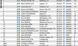
Results: Canadian National Championships 2019
Jul 28, 2019 from pinkbike.com
Check out all the results from the 2019 Canadian National Championships.
Sub Regions
- Adjala-Tosorontio (38)
- Barrie (158)
- Bradford (134)
- Clearview Township (199)
- Collingwood (166)
- Essa Township (44)
- Innisfil (24)
- Midland (68)
- New Tecumseth (14)
- Orillia (12)
- Oro-Medonte (654)
- Copeland Forest (182)
- East Coulson Swamp Reserve (0)
- Hardwood Ski and Bike (130)
- Horseshoe Valley Bike Park (28)
- Oro Hills (4)
- SCMBC - Amos Tract Trail Network (4)
- SCMBC - Heights of Horseshoe (14)
- SCMBC - ORO Trail Network (57)
- Simcoe County Forest - Amos Tract (5)
- Simcoe County Forest - Arbour Tract (4)
- Simcoe County Forest - Barton Tract (1)
- Simcoe County Forest - Boys Tract (2)
- Simcoe County Forest - Breedon Tract (12)
- Simcoe County Forest - Centennial Tract (2)
- Simcoe County Forest - Crawford Tract (9)
- Simcoe County Forest - Douglas Tract (8)
- Simcoe County Forest - Drury Main Tract (22)
- Simcoe County Forest - Elsie Mills Tract (6)
- Simcoe County Forest - Hutchison/Brown Tract (5)
- Simcoe County Forest - Johnson Tract (8)
- Simcoe County Forest - Marrin Tract (4)
- Simcoe County Forest - North Barr Tract (32)
- Simcoe County Forest - Oro Tract (0)
- Simcoe County Forest - Schumacher Tract (11)
- Simcoe County Forest - South Barr Tract (10)
- Simcoe County Forest - Strachan Tract (41)
- Simcoe County Forest - Sutherland Tract (5)
- Simcoe County Forest - Tustin Tract (8)
- The Heights Ski & Country Club (7)
- Penetanguishene (30)
- Ramara (14)
- Severn (48)
- Springwater (393)
- Crown Land - Springwater (7)
- Doran Park (3)
- Green Pine Park (2)
- Hydro Hill (37)
- SCMBC - Hickling Trail Network (8)
- Simcoe Admin/Sports Complex Trail Area (80)
- Simcoe County Forest - Caston Tract (1)
- Simcoe County Forest - Cooper Tract (1)
- Simcoe County Forest - Coughlin Tract (13)
- Simcoe County Forest - Craighurst Tract (8)
- Simcoe County Forest - Fisher Tract (1)
- Simcoe County Forest - Freele Tract (4)
- Simcoe County Forest - Graham Tract (11)
- Simcoe County Forest - Hendrie Main Tract (34)
- Simcoe County Forest - Hickling Tract (2)
- Simcoe County Forest - Ivey Tract (2)
- Simcoe County Forest - Midhurst Tract (7)
- Simcoe County Forest - Millennium Tract (5)
- Simcoe County Forest - Museum Tract (8)
- Simcoe County Forest - O'Niell Tract (4)
- Simcoe County Forest - Orr Lake (28)
- Simcoe County Forest - Orrock Creek North East Tract (8)
- Simcoe County Forest - Orrock Creek North/South Tracts (35)
- Simcoe County Forest - Phelpston Tract (10)
- Simcoe County Forest - Smith/Tiffin Tracts (5)
- Simcoe County Forest - Stoney Tract (11)
- Simcoe County Forest - Williams Tract (3)
- Snow Valley Area Trails (22)
- Snow Valley Ski Resort (14)
- Springwater KOA (3)
- Springwater Provincial Park (18)
- Tay Township (21)
- Tiny (77)
- Wasaga Beach (160)
Popular Simcoe County Mountain Biking Trails
• 95 ★ 4.6 • 1,598 ft • 0 ft • 1,397 •
Flow trail with a few small rooty sections, lots of small/medium jumps, and more berms than you can shake a stick at. One of the original Horseshoe DH trails, located by the southernmost triple chair.
• 90 ★ 3.5 • 1,348 ft • 0 ft • 1,303 •
Mild smooth downhill trail with small berms and descents to practice on.
• 100 ★ 3.5 • 988 ft • 0 ft • 1,229 •
Popular green difficulty family friendly singletrack. This mountain bike primary trail can be used downhill only and has a easy overall physical rating with a 0 ft green climb. Trail visibility is always easy to follow. On average it takes minutes to complete this trail.
• 100 ★ 4.5 • 4 miles • 286 ft • 1,207 •
Highly rated popular blue difficulty singletrack. This mountain bike primary trail can be used downhill primary and has a moderate overall physical rating with a 286 ft blue climb. Trail visibility is always easy to follow. On average it takes 27 minutes to complete this trail.
• 100 ★ 0.0 • 719 ft • 0 ft • 1,202 •
Popular green difficulty singletrack. This multi-use trail can be used both directions and has a easy overall physical rating with a 0 ft green climb. On average it takes minutes to complete this trail.
• 80 ★ 4.3 • 1,909 ft • 0 ft • 1,190 •
One of the HSBP favourites, fast and flowy machine made trail. If your significant other won't show you support, these berms certainly will. Ideal trail for anyone looking to go fast, or take it easy. It's a great "One Size Fits All"...
• 100 ★ 4.0 • 2,766 ft • 187 ft • 1,181 •
is primarily used to climb up to the "5 Points" ridge top. The climb is a tough one, with tight turns, punchy climbs and littered with roots. It will get the blood flowing.
• 100 ★ 3.8 • 1,404 ft • 13 ft • 1,164 •
A trail primarily used to access the DH trails at the other end.
Simcoe County Mountain Bike Routes
Fun Course Featured
★ 5.0 • 3 miles • 199 ft • 5 • Loop •
An easy beginner course. Starts with slow climb to high point on double track. Easy single track and ends...
SCMBC Oro FatBike 2025 Featured
★ 5.0 • 14 miles • 982 ft • 10 • Loop •
SCMBC Oro fat bike route for 2025
★ 3.5 • 7 miles • 890 ft • 16 • Loop •
Hope you enjoy this great tour of the Copeland Forest! Starts and ends at the parking lot north of...
★ 5.0 • 5 miles • 269 ft • 12 • Loop •
Easy to moderate ride. Starts with long double track climb and finishes with nice downhill run.
★ 3.9 • 99 miles • 1,241 ft • 0 • Loop •
The Simcoe County Loop Trail is a 160 kilometre loop that travels through nine municipalities, reaches...
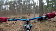
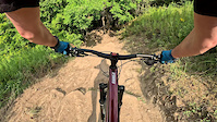
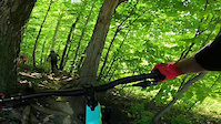
Photos of Simcoe County Mountain Bike
Videos of Simcoe County Mountain Bike
featured
![Copeland - April 16th, 2017]()
trail: Copeland Downhill
4:14 |
906 |
Apr 16, 2017
trail: Shake N' Brake
0:54 |
60 |
Aug 17, 2025
trail: Smith's Thriller
2:14 |
27 |
Sep 4, 2024
trail: Dark Roast
0:32 |
|
Sep 2, 2024
trail: Horseshoe O-Cup XC Trail
0:23 |
234 |
May 8, 2024

trail: 2nd Bluff Trail
0:29 |
|
Mar 23, 2024

trail: Despicable Me
4:12 |
31 |
Nov 17, 2023
trail: Party Train
0:41 |
105 |
Aug 3, 2023
Current Trail Warnings
| status | trail | date | condition | user | info |
|---|---|---|---|---|---|
| Pines Copeland Forest | Jun 3, 2026 @ 10:20pm (America/Toronto) 23 hours | Dry | Canadmos TRAILFORKS | This trail os completely blocked with trees. | |
| Around the Top Copeland Forest | Jun 3, 2026 @ 10:19pm (America/Toronto) 23 hours | Dry | Canadmos TRAILFORKS | Large tree down, blocking the trail, near... | |
| Express Climb The Heights Ski & Country Club | May 20, 2026 @ 10:40pm (America/Toronto) May 20, 2026 | Ideal | Canadmos TRAILFORKS | Big tree down in the forest. |
Recent Trail Reports
Activity Feed
| username | action | type | title | date |
|---|---|---|---|---|
| Canadmos | add | poi | activity #96250984 and 2 more | Jun 4, 2026 @ 2:05pm 4 hours |
| Canadmos | add | poi | activity #96250862 and 1 more | Jun 4, 2026 @ 2:02pm 4 hours |
| Canadmos | add | trail | activity #96250767 and 2 more | Jun 4, 2026 @ 2:00pm 4 hours |
| Canadmos | add | region | activity #96250714 | Jun 4, 2026 @ 1:59pm 4 hours |
| elijahric | ridden | trail | activity #96237943 and 17 more | Jun 4, 2026 @ 10:29am 7 hours |
Recent Comments
| username | type | title | comment | date |
|---|---|---|---|---|
| report | The 2 down trees have been removed yesterday..... | Jun 3, 2026 @ 1:17pm 1 day | ||
| report | AMEN | Jun 1, 2026 @ 3:07pm Jun 1, 2026 | ||
| report | Trail has 2 large trees, one 12+ inch diam... | May 31, 2026 @ 10:07am May 31, 2026 | ||
| trail | Someone cut the easy log ride over the creek... | May 20, 2026 @ 7:48pm May 20, 2026 | ||
| trail | Lots of brush chopped down & laying across... | Nov 9, 2025 @ 8:19am Nov 9, 2025 |
Local Badges
-
Horseshoe Single Ride Thriller v218 awarded -

Epic Mountain Bike Climb 2k0 awarded -

10 Green Trails0 awarded -
10 Green Trails38 awarded -
10 Green Trails4 awarded -
Epic Mountain Bike Climb 2k0 awarded
Bike & Skill Parks
| name | type | city | rating |
|---|---|---|---|
| Horseshoe Valley Bike Park | bike park | Oro-Medonte | |
| Wasaga Beach Bike Park | skill park | Wasaga Beach | |
| Collingwood Cycle Pump Track | skill park | Collingwood |
Activity Type Stats
| activitytype | trails | distance | descent | descent distance | total vertical | rating | global rank | state rank | photos | reports | routes | ridelogs |
|---|---|---|---|---|---|---|---|---|---|---|---|---|
| Mountain Bike | 2,206 | 1,277 miles | 64,541 ft | 412 miles | 1,184 ft | 1,308 | 10,357 | 71 | 138,655 | |||
| E-Bike | 789 | 472 miles | 24,196 ft | 158 miles | 1,056 ft | 19 | 6,695 | 11 | 3,501 | |||
| Gravel Bike | 79 | 57 miles | 1,906 ft | 23 miles | 988 ft | 846 | 1 | 1,249 | ||||
| Adaptive Bike | 82 | 67 miles | 2,657 ft | 26 miles | 988 ft | 284 | 1 | 13 | ||||
| Winter Fat Bike | 208 | 163 miles | 8,547 ft | 63 miles | 951 ft | 4 | 946 | 4 | 105 | |||
| Horse | 824 | 449 miles | 21,873 ft | 150 miles | 1,001 ft | 1,422 | 112 | |||||
| Hike | 2,284 | 1,335 miles | 66,581 ft | 433 miles | 1,184 ft | 222 | 9,921 | 13 | 12,353 | |||
| Trail Running | 2,273 | 1,329 miles | 66,286 ft | 431 miles | 1,184 ft | 7 | 10,121 | 15 | 6,978 | |||
| Dirtbike/Moto | 446 | 353 miles | 10,938 ft | 107 miles | 725 ft | 3 | 597 | 2 | 322 | |||
| ATV/ORV/OHV | 248 | 180 miles | 4,544 ft | 56 miles | 1,001 ft | 7 | 560 | 1 | 80 | |||
| Snowmobile | 456 | 330 miles | 9,895 ft | 119 miles | 1,020 ft | 215 | 1 | 97 | ||||
| Snowshoe | 1,857 | 1,109 miles | 54,534 ft | 354 miles | 1,178 ft | 3 | 2,865 | 11 | 1,529 | |||
| Downhill Ski | 138 | 36 miles | 17,087 ft | 29 miles | 965 ft | 8 | 139 | 4,737 | ||||
| Backcountry Ski | 16 | 9 miles | 1,624 ft | 5 miles | 896 ft | 218 | 2 | 459 | ||||
| Nordic Ski | 1,365 | 913 miles | 34,518 ft | 281 miles | 1,181 ft | 1,851 | 9 | 7,616 |
Frequently Asked Questions About Simcoe County
▼
What are the best places to ride in Simcoe County?
Simcoe County has 133 areas to explore for mountain biking. The top rated areas are:
▼
What are the highest rated mountain biking trails in Simcoe County?
The highest rated mountain biking trails in Simcoe County are:
- Copeland Downhill (4.6/5)
- Smith's Thriller (4.6/5)
- Party Train (4.5/5)
- 5th Dimension (4.5/5)
- Amos Tract Red (4.5/5)
▼
What is the best time of the year to ride in Simcoe County?
Based on ride log data, the most popular months to ride in Simcoe County are:
- July (2,714 activities)
- June (2,248 activities)
- August (2,159 activities)
▼
What is the longest trail in Simcoe County?
The longest trail in Simcoe County is Oro-Medonte Rail Trail at 28.1 km. View all trails sorted by distance.
Activities
- Simcoe County Mountain Biking Trails
- Simcoe County E-Biking Trails
- Simcoe County Horseback Trails
- Simcoe County Hiking Trails
- Simcoe County Trail Running Trails
- Simcoe County Dirtbiking Trails
- Simcoe County ATVing/Offroading Trails
- Simcoe County Snowmobiling Trails
- Simcoe County Snowshoeing Trails
- Simcoe County Skiing Trails
- Simcoe County Backcountry Skiing Trails
- Simcoe County Nordic Skiing Trails
Trails
- By markholloway
 Trailforks Map Team & contributors
 - Admins: Canadmos
- #10090 - 27,349 views
- simcoe county activity log | embed map of Simcoe County mountain bike trails | simcoe county mountain biking points of interest polygons
Downloading of trail gps tracks in kml & gpx formats is enabled for Simcoe County.
You must login to download files.