3,757 ft
Distance
3 ft
Climb
-196 ft
Descent
00:05:14
Avg time
5th Dimension Details
-
Activities
- Mountain Bike
- Hike
- Trail Running
- Snowshoe
-
Riding AreaCopeland Forest
Oro-Medonte, Ontario -
Difficulty Rating
-
Trail TypeSingletrack
-
DirectionDownhill PrimaryPopular direction shown
-
Climb DifficultyBlue
-
Physical RatingModerate
-
Dogs AllowedYes
-
Global Ranking
-
Local Popularity95 in Mountain Biking [+]
- 70 in Trail Running
- 100 in Hiking
- 90 in Snowshoeing
-
Land ManagerMNRF
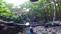
5th Dimension is primarily a downhill type trail, starting at the P4 parking lot and ending towards the bottom of a ridge. It features a rock pile, many very fast sections, roots and steep sections. There is one short but punchy climb in the middle.
This trail is best ridden "down" the hill, but keep mind hikers/bikers might be headed up the hill. Keep alert
Local Trail Association
-
Please consider joining or donating to the local trail association to supportdonate to earn trail karma!
trail development & maintenance.
Traditionally Indigenous Territory
More Stats for 5th Dimension bike trail trail
-
Altitude change-194 ft
-
Altitude min870 ft
-
Altitude max1,067 ft
-
Altitude start1,064 ft
-
Altitude end869 ft
-
Grade-5.2%
-
Grade max-23.4%
-
Grade min2.5%
-
Distance climb180 ft
-
Distance down2,408 ft
-
Distance flat1,132 ft
-
Avg time00:05:14
-
Avg reverse time00:14:20
- view trail stats
close
Trail Conditions
- Unknown
- Snow Groomed
- Snow Packed
- Snow Covered
- Snow Cover Inadequate
- Freeze/thaw Cycle
- Icy
- Prevalent Mud
- Wet
- Variable
- Ideal
- Dry
- Very Dry
Trail Flow (Ridden Direction)
Trailforks scans users ridelogs to determine the most popular direction each trail is ridden. A good flowing trail network will have most trails flowing in a single direction according to their intension.
The colour categories are based on what percentage of riders are riding a trail in its intended direction.
- > 96%
- > 90%
- > 80%
- > 70%
- > 50%
- < 50%
- bi-directional trail
- no data
Trail Last Ridden
Trailforks scans ridelogs to determine the last time a trail was ridden.
- < 2 days
- < 1 week
- < 2 weeks
- < 1 month
- < 6 months
- > 6 months
Trail Ridden Direction
The intended direction a trail should be ridden.
- Downhill Only
- Downhill Primary
- Both Directions
- Uphill Primary
- Uphill Only
- One Direction
Contribute Details
Colors indicate trail is missing specified detail.
- Description
- Photos
- Description & Photos
- Videos
Trail Popularity ?
Trailforks scans ridelogs to determine which trails are ridden the most in the last 9 months.
Trails are compared with nearby trails in the same city region with a possible 25 colour shades.
Think of this as a heatmap, more rides = more kinetic energy = warmer colors.
- most popular
- popular
- less popular
- not popular
ATV/ORV/OHV Filter
Max Vehicle Width
inches
Radar Time
x
Activity Recordings
Trailforks users anonymized public ridelogs from the past 6 months.
- mountain biking recent
- mountain biking (>6 month)
- hiking (1 year)
- moto (1 year)
Activity Recordings
Trailforks users anonymized public skilogs from the past 12 months.
- Downhill Ski
- Backcountry Ski
- Nordic Ski
Jump Magnitude Heatmap
Heatmap of where riders jump on trails. Zoom in to see individual jumps, click circles to view jump details.
Trails Deemphasized
Trails are shown in grey.
Only show trails with NO bikes.
Directions to 5th-dimension trailhead
(44.574790, -79.655800)
update trails status or condition
5th Dimension Trail Reports
view all reports »
Recent Ridelog Activity on Trail
Past Week
- 27 rides
- 13 miles avg distance
6 Months
- 156 rides
- 12 miles avg distance
All
- 2,182 rides
Photos
more »
Routes with this trail
more »
Videos
more »
Nearby Trails
- Pines 459 ft
- Rock Wall #2 1,276 ft
- Copeland - No Name 1,601 ft
- Rock Wall #1 1,614 ft
- Sidecar 2,224 ft
- embed 5th Dimension trail on your website
- By Canadmos
TRAILFORKS & contributors
- #89121 - 3,208 views
- subscribe
- login to download gpx or kml files.
Open trail in mobile app